
Fujii Tomitarō (藤井富太郎)

Fujii Tomitarō (藤井富太郎; fl. c. 1878 – 1900) was a Japanese cartographer active in the Meiji period, best known for producing a map of Nagoya.
AKA: 藤井富太郎
Nagoya at the start of its industrialization.
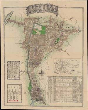
愛知縣第一區名古屋并熱田全圖 / [A full map of Nagoya and Atsuta in the first district of Aichi Prefecture].
$1,000.00
Acquire
- Digital Map Information
- Suitable for large format printing
- File Size: 47.7 MB
- File Type: ZIP / TIFF
- ICC color profile embedded
- Delivered instantly via download link
This is a remarkable 1878 Fujii Tomitarō (藤井富太郎) map of Nagoya and Atsuta in Aichi Prefecture, Japan. It was made a decade after the Meiji Restoration, which inaugurated a rapid modernization of the country, and shows the immediate effects of the reform program on Nagoya. The frequent administrative changes of the Meiji era (discussed below) required regular updating of maps, which was likely the impetus for this map's creation. (more details)