
Garnier, F.A.

F.A. Garnier (1803 - 1863) was a French cartographer who published the Atlas sphéroidal et universel de géographie in 1862 as his only work. It is said that he spent fifteen years creating the maps for the atlas.
A beautiful celestial map of the sky as seen from Paris.
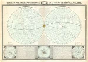
Tableau d'uranographie moderne ou système sphéroïdal céleste.
$250.00
Acquire
- Digital Map Information
- Suitable for large format printing
- File Size: 45.52 MB
- File Type: ZIP / TIFF
- ICC color profile embedded
- Delivered instantly via download link
Drawn as if painted inside two imaginary vaults or domes, this 1860 Garnier celestial or star map details the stars and planets as they would appear in Paris over one calendar year. Two lines present in each hemisphere mark Paris's northern and southern horizons and inform the viewer that any stars between these lines and the poles would never be seen from Paris. Centered on the equinoctial colure (the celestial great circle that passes through the celestial poles and both equinoxes), the Sun is placed where the two spheres meet, and its ecliptic curves its way across the heavens. All twelve months appear along the ecliptic and indicate the passage of time. Major constellations are labeled, although not drawn, leaving some uncertainty as to their exact composition. (more details)