
Hanna, Phil Townsend

Phil Townsend Hanna (August 24, 1896 - June 1, 1957), a lifelong Angelino, was an author, historian, and longtime public relations director for the Automobile Club of Southern California (ACSC). Born in Los Angeles, Hanna attended Polytechnic High School and then the University of Southern California. After graduating, he worked as the automobile editor of the Los Angeles Tribune, then worked for the Los Angeles Times, and the Los Angeles Bureau of the Associated Press. In 1926, Hanna became the editor of the ACSC magazine Touring Topics, later renamed Westways and by 1941 was in charge of public relations for the entire ACSC. He also wrote several books on Californian, Mexican, and Latin American history, including California Under Twelve Flags and The Dictionary of California Land Names, and published translations of Mexican and South American literature. Hanna also served as director of the California Library Council and the Friends of the Huntington Library, was a trustee of the Southwest Museum (Southwest Museum of the American Indian), and was an active member of several California historical and cultural clubs.
Californian Commemoration of the Spanish Empire.
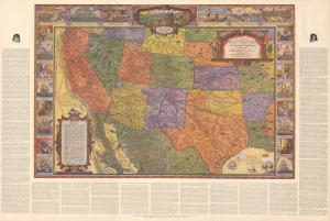
A Map of Exploration in the Spanish Southwest 1528-1793.
$275.00
Acquire
- Digital Map Information
- Suitable for large format printing
- DPI: 600
- File Size: 114.66 MB
- File Type: ZIP / TIFF
- ICC color profile embedded
- Delivered instantly via download link
This is a large-format 1932 pictorial map of the American Southwest, produced by the Automobile Club of Southern California. It is characteristic of the early 20th-century romanticization of the Spanish colonial era, which played an important part in the development of a distinctly Southern Californian identity. The map emerged during the Golden Age of American Pictorial Mapmaking. (more details)