
Harris, Harding

Harding Harris (September 12, 1768 - March 20, 1808) was an American lawyer and landowner. Born in Johnston, Rhode Island, Harris' only known cartographic achievement was helping his father Caleb Harris (August 9, 1739 - January 16, 1812) compile a landmark map of Rhode Island, the first accurate map of the state. Harding Harris married Abigail Smith on August 14m 1796, with whom he had 7 children. Harris died on March 20, 1808, of tuberculosis.
First specific map of Rhode Island published in the United States.
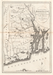
The State of Rhode Island; compiled from the Surveys and Observations of Caleb Harris. By Harding Harris.
$500.00
Acquire
- Digital Map Information
- Suitable for large format printing
- File Size: 5.66 MB
- File Type: ZIP / TIFF
- ICC color profile embedded
- Delivered instantly via download link
This is an example of Matthew Carey's 1795 reduction of Caleb and Harding Harris' unobtainable landmark map of Rhode Island. It is the earliest obtainable map of Rhode Island based on contemporaneous surveys and the first specific map of Rhode Island published in the United States. (The Harris map has appeared only once on the market in the last 25 years.) Harris' mapping of the state remained cutting-edge until 1831 when Stevens published his Topographical Map of the State of Rhode Island. (more details)