
Herbert, Isaac Hand

Isaac Hand Herbert (April 12, 1812 - March 8, 1846) was a surveyor active in Kings County (Brooklyn), New York, in the mid-19th century. Little is known of his life and training, and only one of his maps is cataloged in institutional collections, but he appears to have specialized in property surveys for the quickly developing areas of Brooklyn and Staten Island in the 1840s. Newspaper records show in addition to being a City Surveyor for the City of Brooklyn, Herbert was a leading member of the 'Native American Democratic Association,' a nativist political group that presaged the 'Know-Nothing' American Party, in Brooklyn. His son, Isaac H. Herbert, Jr. (1846 - 1918), followed somewhat in his father's footsteps, becoming a real estate developer in Brooklyn in the late 19th century.
Williamsburg at the Outer Edge of the Expanding City.
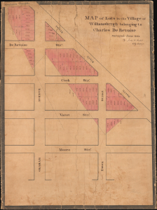
Map of Lots in the Village of Williamsburgh belonging to Charles De Bevoise.
$1,200.00
Acquire
- Digital Map Information
- Suitable for large format printing
- Full resolution TIFF file
- ICC color profile embedded
- Delivered instantly via download link
This is a unique 1843 Isaac H. Herbert original manuscript survey plat map of a portion of today's Brooklyn, New York, on the border of Williamsburg and Bushwick. It presents the area as it was beginning to transition from farmland to an urban environment, with a fixed street grid and closely packed lots for housing and commercial space. (more details)