
Institut Cartographique Militaire
Institut Cartographique Militaire (1878 - 1947) was Belgium's military mapping agency during its operational lifespan from 1878 to 1947. Succeeding the post-independence Dépôt de la Guerre et de la Topographie, the ICM was institutionalized under the Ministry of War to create highly accurate, official topographic maps of the kingdom and, later, its colonies (especially the Belgian Congo). One of the first tasks of the ICM was to produce a comprehensive set of topographic maps of Belgium using the latest geodetic methods on a consistent scale (1:2000000), which was also later extended to the Congo. It maps were printed by an in-house print shop called the Imprimerie lithographique de l'Institut Cartographique Militaire. The Institut was deeply affected by Belgium's precarious position in European geopolitics and its staff, facilities, and information was requisitioned by the Germans during occupations in both world wars. Following the Second World War, the ICM was phased out, transitioning into the Institut Géographique Militaire in 1947, which eventually evolved into today's civilian Institut Géographique National.
Resource Extraction in the Belgian Congo.
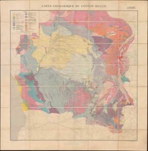
Carte Geologique du Congo Belge.
$1,000.00
Acquire
- Digital Map Information
- Suitable for large format printing
- Full resolution TIFF file
- ICC color profile embedded
- Delivered instantly via download link
This is a large-format 1930 folding geological map of the Belgian Congo, prepared by geologist Paul Fourmarier. The map is a product of Belgian colonial efforts to pillage the Congo's vast natural resources - copper, cobalt, diamonds, and other minerals - through exploitative forced labor. (more details)