
Jacobs, Stanislas Joseph

Stanislas Joseph Jacobs (18?? – July 5, 1867) was a French line engraver active in Paris during the middle part of the 19th century. Jacobs did work for the both the Dépôt de la Guerre ad Dépôt de la Guerre and the Dépôt des Cartes et Plans de la Marine. He often worked with Jacques-Marie Hacq. His most important publication is most likely the Eugène Duflot de Mofras map of the American west, published in 1844. Stanislas was a member of the French Société de Géographie from 1842. In 1862 Stanislas' son, Alfred Joseph Jacobs (December 15, 1827 - July 16, 1889), also an engraver, descended into mental illness and was consigned the Charenton hospice. His son's illness apparently catapulted Stanislas into a deep unremitting despair. Stanislas retired in 1862. He was married to Thérèse Alexandrine Outrequin (January 28, 1804 – February 20, 1873). He lived in Paris at Rue De Condé, 1.
A rare nautical chart of the French overseas collective St. Pierre.
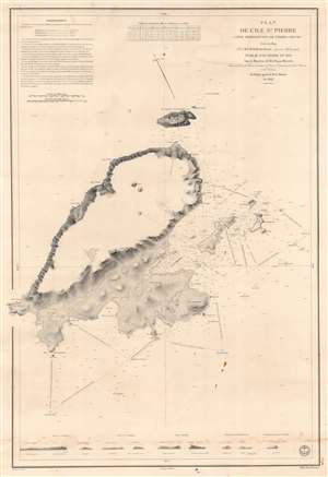
Plan de l'Ile St. Pierre (Côte Méridionale de Terre Neuve).
$450.00
Acquire
- Digital Map Information
- Suitable for large format printing
- DPI: 600
- File Size: 81.96 MB
- File Type: ZIP / TIFF
- ICC color profile embedded
- Delivered instantly via download link
This is an 1834 Jules de la Roche-Poncié and Dépot de la Marine nautical chart or maritime map of St. Pierre Island, part of the French overseas collective, ('collectivité d'outre-mer'), St. Pierre and Miquelon. St. Pierre dominates the sheet, and its coastlines appear in impressive detail. Coves, points, bays, and other coastal locations are labeled. The Ile aux Chiens, Ile aux Vainqueurs, the Ile aux Pigeons, and Grand Colombier are illustrated and labeled, along with numerous smaller coastal islands. Depth soundings, navigation directions, and other notations provide mariners with navigational assistance. Nine coastal views appear along the bottom border to further aid navigation. (more details)
The French set their eyes on Singapore.
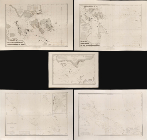
Carte des Atterrages de Singapore. / Carte Particulière des détroits de Singapore, Durian et Rhio. / Carte des Détroits de Singapore, Durian et Rhio et des Parages Environnants. / Carte du Détroit del Malacca Partie Septentrionale. / Carte du Détroit de Malacca Partie Méridionale.
$22,000.00
Acquire
- Digital Map Information
- Suitable for large format printing
- Full resolution TIFF file
- ICC color profile embedded
- Delivered instantly via download link
An exceptional set of five rare 1840s nautical maps/charts detailing Singapore, Malaya, and the Straits of Malacca and Singapore compiled by Urban Dortet de Tessan for the French Dépôt-Général de la Marine. The charts correspond to the Lagrené Mission, a French attempt to establish a colonial presence in East and Southeast Asia that challenged British regional hegemony. (more details)