
Kato Takashiro (加藤隆四郎)

Kato Takashiro (加藤隆四郎, also read as Kato Ryūshirō; fl. c. 1930 - 1943) was a Japanese cartographer and illustrator who made several maps of China and Asia during World War II, often appearing in magazines published by Kodansha (講談社).
AKA: 加藤隆四郎
Pan-Eurasian Unity?
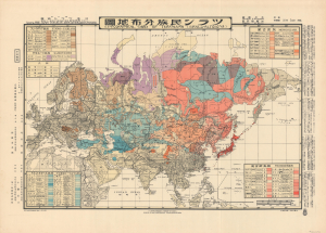
ツラン民族分佈地圖 / [Ethnographic Card of Turanians (Uralo-Altaians)].
$4,000.00
Acquire
- Digital Map Information
- Suitable for large format printing
- File Size: 36.62 MB
- File Type: ZIP / TIFF
- ICC color profile embedded
- Delivered instantly via download link
An intriguing piece of ethnographic Interwar-WWII propaganda, this bilingual Japanese-English map, based on a 1933 manuscript by Kato Ryūshirō, displays the purported peoples of the 'Turanian' community. The present example was printed in 1943 in Hungary by the Turan Federation of Hungary and the Royal Hungarian Defense Cartography Institute. (more details)