
Longuet

Longuet (fl. c. 1839 - 1858), or Chez Longuet, was a French geographic publisher active in Paris in the mid-19th century. He took over the firm of Charles Simonneau (fl. c. 1803 - 1838) in 1839. Chez Longuet was, in turn, taken over by Lanée sometime around 1858. He published initially from 6 Rue de la Paix but later moved to 8 Rue de la Paix, Paris.
Beginning of the Haussmann Renovations.
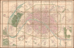
Plan de Paris Fortifié et des Communes Environnantes.
$1,750.00
Acquire
- Digital Map Information
- Suitable for large format printing
- File Size: 127.53 MB
- File Type: ZIP / TIFF
- ICC color profile embedded
- Delivered instantly via download link
This is a stunning 1856 Longuet city plan or map of Paris, France, during the reign of Napoleon III and the Second French Empire. The map illustrates the early stages of the Georges-Eugène Haussmann Renovations of Paris, which took place from 1853 - 1870. (more details)