
Lucini, Antonio Francesco

Antonio Francesco Lucini (January 1, 1610 - 1661), a.k.a. Anton, was an Italian engraver and printmaker. Lucini was born in Florence born in 1605. Lucini initially studied engraving with Stefano della Bella (1610 - 1664) under Jacques Callot (c 1592 - 1635), who lived in Florence from 1612 to 1621. He is recorded in 1616 as Callot's assistant in Florence. After 1621, he joined flowed Callot in Nancy to continue his training. He returned to Florence sometime before 1631, when he published a series of plates on the Great Siege of Malta. He is best known in cartographic circles as the engraver for Sir Robert Dudley's seminal maritime atlas Dell'Arcano del Mare (Of the Mysteries of the Sea), published in Florence in 1645 - 1646. The 200 engraved plates and 146 charts which Lucini produced for Dudley occupied 12 years occupied 12 years of his life and consumed some 5000lbs of copper. The engravings exhibit Lucini’s masterful craftsmanship and are outstanding examples of Italian Baroque engraving. Indeed, while Dudley was a master chartmaker, it is Lucini's virtuoso engraving and fine calligraphy that most define Dudley's work.
Earliest published sea chart focusing on the California coast!
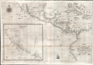
Carta prima generale d'America dell'India Occidentale e Mare del Zur.
$7,000.00
Acquire
- Digital Map Information
- Suitable for large format printing
- File Size: 26.19 MB
- File Type: ZIP / TIFF
- ICC color profile embedded
- Delivered instantly via download link
This is the 1646 first state of Robert Dudley's chart of the middle part of the Americas, illustrating the proximity of the Caribbean Sea and the Pacific Ocean and emphasizing the narrow parts of Central America dividing the two bodies of water. The chart features the western part of the Caribbean, but it is particularly noted for being the first printed sea chart to focus on the Pacific coast, including California. It is, along with Dudley's more narrowly focused charts, the first printed chart of the West Indies and South Florida to employ the Mercator Projection. An inset chart in the lower left focuses specifically on the coast of California, from Baja to Cap Mendocino. (more details)
First printed English Nautical Chart of New York and New England. / First use of the name 'Connecticut' in any form.
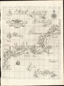
Carta particolare della nuova Belgia è parte della nuova Anglia La longitudiné Cominca da l'Isola di Pico d'Asores. D'America Carta II.
$40,000.00
Acquire
- Digital Map Information
- Suitable for large format printing
- File Size: 14.46 MB
- File Type: ZIP / TIFF
- ICC color profile embedded
- Delivered instantly via download link
This is a superb example of Robert Dudley's 1647 / 1661 nautical map of the coast of New York and New England - according to Burden, the 'first printed sea chart of New England and the New Netherlands.' Moreover, it is the first chart of New England to be produced by an Englishman. The chart's portolan-like lines and exquisite Florentine calligraphy distinguish it as one of the most beautiful works dedicated to the region. It is a rarity on the market, and a prize map for collectors of New York and New England. (more details)