
Maeda Komakichi (前田駒吉 c. 1900-1949

Maeda Komakichi (前田駒吉; c. 1900 - 1949) was a Japanese cartographer based in Nagano who mostly produced maps of his hometown, generally published by Kinkado (金華堂書店).
The Japanese seize Manchuria!
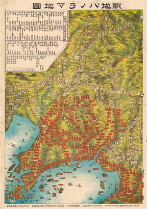
戰地パノラマ地圖 / [Battlefield Panorama Map].
$550.00
Acquire
- Digital Map Information
- Suitable for large format printing
- Full resolution TIFF file
- ICC color profile embedded
- Delivered instantly via download link
This is a rare Komakichi Maeda (前田駒吉) map of the Liaodong Peninsula (辽东半岛) and southern Manchuria, China. The map details Japanese and Russian troop positions around September 15, 1904, during the Russo-Japanese War (1904 - 1905). The table at the top-left provides the distance between cities (Port Arthur, Mukden, Liaoyang, etc.) and towns on or near the frontlines. Many of these names would have been familiar to the Japanese public, which was inundated with information about the war in newspapers and would therefore have been able to use this map as a visual aid to daily war progress updates. The table also gives the distance by sea from Nagasaki to strategic points in Korea and China. The distances are marked by the Japanese unit of measurement ri (里), which is much longer (about 2.44 miles) than the traditional Chinese li, which uses the same character. Although the map does not have a legend, aside from the positions of Japanese and Russian troops and ships as well as the names of cities and villages where they were stationed, it traces roads (red lines) and railways (black and white lines). Notably, it illustrates the route of the all-important China Eastern Railway, namely the southern section connecting Harbin (哈爾濱) to Mukden (or Fengtian 奉天), Dalian (金州) and Port Arthur (旅順口Lüshunkou), one of the main objectives of the war. (more details)