
Mangin, Joseph-Francois

Joseph-Francois Mangin (June 10, 1758 - 1818) was an architect, city surveyor, and civil engineer active in New York during the late 18th and early 19th century. Mangin was born in Vosages, France, the son of Jean-Baptiste François Mangin, the king's surgeon. He went to both high school and University in Nancy, graduating in 1781. He apprenticed under Ange-Jacques Gabriel in the design of the Place de la Concorde, Paris. He then traveled to the French colony of Saint Domingue (Haiti), presumably to make his fortune, but was force to flee in 1793 because of the 1792 Haitian Revolution (1792 - 1796). By this time the French Revolution was well underway, Mangin's family, royalists all, were arrested and executed at the guillotine. Mangin came to New York city in 1786 as a refugee, but quickly acquired the patronage of Alexander Hamilton, and was admitted as a Freeman of New York on May 9, 1796. He submitted several projects to the Common Council of New York, including a recommendation to drain the Collect Pond and various improvements to the port facilities. In 1797, he was commissioned, along with fellow surveyor Casimir Goerck, to make a large scale plan of New York City - the first since American independence. He presented the plan to the Common Council in 1801. While the council initially approved of the plan, it was dismissed in 1803 due to anti-Hamilton political maneuvering. Nonetheless, the Mangin-Goerck Plan, which proposed landfill work and a new street grid, was highly influential. Mangin is also today credited with the principal design of New York's first City Hall although fellow designer, John McComb unilaterally denied Mangin's claims in an attempt to steal credit for the work. Mangin remained favorite with the Common Council and was commissioned to work on the 1811 Commissioner's Plan of New York City, a truly meritorious work that laid out the permanent street grid for most of Manhattan. Mangin left New York in 1818, presumably back to France, and is believe to have died there.
Earliest obtainable example of the influential Goerck-Mangin Plan of New York City - published while it was still relevant.
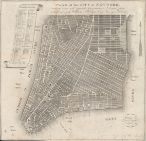
PLAN of the CITY OF NEW-YORK, with the recent and intended Improvements. New York, 1807.
$4,000.00
Acquire
- Digital Map Information
- Suitable for large format printing
- File Size: 10.32 MB
- File Type: ZIP / TIFF
- ICC color profile embedded
- Delivered instantly via download link
This important 1807 map of lower Manhattan, New York City, published by Isaac Riley, William Bridges, and Peter Maverick, is a most unusual piece with a confused and complex history. It predates the 1811 Commissioner's Plan, thus representing the definitive plan of New York City at the time of publication and exerting a profound influence on the developing street grid of Lower Manhattan. It is the earliest obtainable example of one of the most important founding cartographic documents relating to the development of New York's street grid - the Mangin-Goerck map. (more details)