
Mela, Pomponius

Pomponius Mela (died 45 CE) was the first Roman geographer. He produced a short work, De situ orbis libri III, which would continue to be an authority well into the 16th century; geographers such as Ortelius would continue to mine Mela's work for data where modern authorities remained silent. Apart from Pliny's Historia naturalis Mela's work is the only formal geographical work in Classical Latin, and as such it remained in the curriculum well into the 19th century.
18th century depiction of 1st century Africa.
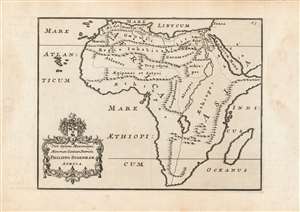
Viro Optimo Maximoque, Minorum Gentium Patricio, Philippo Sydenham Africa.
$300.00
Acquire
- Digital Map Information
- Suitable for large format printing
- DPI: 600
- File Size: 15.32 MB
- File Type: ZIP / TIFF
- ICC color profile embedded
- Delivered instantly via download link
This is a fine example of a scarce and unusual map of Africa, included in scholar John Reynolds' 1739 and 1761 editions of Pomponius Mela's first century geographical work, De Situ Orbis. The map was intended to aid the modern reader with ancient geography, by placing the first century Roman geographer's toponymy in the framework of a more modern delineation of the continent. In order to do so, despite presenting a recognizable 18th century outline of Africa, the mountains and rivers displayed on the map correspond more closely to the ideas of Mela than those of later cartographers. Most obvious among these traits is the lack of any river associated with the Atlantic, and the depiction of the River Nile with its headwaters in a massive lake reminiscent of the westernmost of the pair that would be associated with the later Roman geographer, Ptolemy. (more details)