
Midcontinent Map Company

Midcontinent Map Company (c. 1900 - 1970) was a map publisher based in Tulsa, Oklahoma and later with offices in several states that specialized in county plat maps and abstract maps relating to the oil and gas industry. Founded in Tulsa at the dawn of the great oil boom of the early 20th century, the company both produced its own maps and republished those of others, especially the U.S. Geological Survey, that were useful for oil prospectors. Their maps consistently focused on the middle part of the country, including Oklahoma, Missouri, Mississippi, Illinois, Iowa, and Kansas (though not Texas, which was already well-covered by other map publishers).
New Extraction Methods After the Oil Boom.
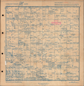
This is a c. 1959 plat map of Okmulgee County, Oklahoma, noting the location of oil wells produced by the Midcontinent Map Co. It demonstrates the state of the oil industry in the county at a time when primary and secondary extraction methods had been exhausted, prompting a move to tertiary methods for extracting oil. (more details)