
Morse, Sidney Edwards

Sidney Edwards Morse (February 7, 1794 - December 24, 1871) was an American geographer, journalist, and inventor. Born in Charlestown, Massachusetts, Morse was the son of the geographer and clergyman Jedidiah Morse (August 23, 1761 - June 9, 1826) and his wife Elizabeth Ann Finley Breese. Morse graduated from Yale in 1811, and also studied theology at Andover Seminary, as well as law at the school in Litchfield, Connecticut. Morse moved to New York City in 1823, where he founded the New York Observer with his brother Richard Cary Morse (1795 - 1868). Together with Henry A. Munson he developed cerography, a printmaking technique using a layer of wax over a metal substrate. Morse used this technique to illustrate his geographical textbooks, including the The Cerographic Atlas of the United States, which he co-published with Samuel Breese. Morse devoted his last few years to experimenting with an invention, called a bathyometer, created to aid in the rapid exploration of the ocean. His invention was exhibited in Paris during the 1869 World's Fair and the following year in New York City.
Texas and California before the Mexican American War.
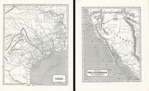
Texas. / Map of The Californias by T.J. Farnham.
$750.00
Acquire
- Digital Map Information
- Suitable for large format printing
- DPI: 600
- File Size: 51.82 MB
- File Type: ZIP / TIFF
- ICC color profile embedded
- Delivered instantly via download link
Maps of the Republic of Texas and Upper California in 1845, issued for Sidney E. Morse's Cerographic Atlas. The maps are printed back-to-back, but collectively represent the region in the year prior to the outbreak of the Mexican-American War (1846 - 1848), in the final days of the Republic of Texas (1836 - 1846) and Mexican California, considered the first atlas map of Upper California. (more details)