
Nirdosh Publications

Nirdosh Publications (fl. c. 1958 - c. 1975) was a map publishing house active in (New) Delhi in the 1960s and 1970s. They were originally based in the Jangpura Market and later moved to Shakapur. The firm primarily produced city plans of major Indian cities and road maps of the various Indian states.
India's railroad network.
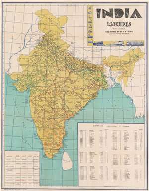
This is a c. 1960 railroad map of India. Depicting India's railroad network in detail, its eight different railways are differentiated by color and then further divided by track gauge. The routes of the Eastern Railway, Western Railway, Southern Railway, and Southeastern Railway are labeled as well. Cities and towns are labeled along every line and a table providing distances between major cities in kilometers occupies the lower right. A key situated in the lower left explains notations used to differentiate railways and broad-, meter-, and narrow-gauge lines. A decorative title cartouche appears in the upper right bordered by vignettes of historical train engines. (more details)