
Nissen, Hilary Nicholas

Hilary Nicholas Nissen (1813 - August 25, 1877) was a British stationer, politician, sheriff, and businessman. Nissen founded the firm Nissen and Parker at 43 Mark Lane, London. Parker we have been unable to isolate. The firm is best known for servicing the London financial market, printing bank notes, checks, certificates, drafts, maps, and books. By 1867, they became Nissen, Parker, and Arnold. By the early 20th century, the firm changed to Nissen and Arnold. At its height, the firm serviced nearly 2000 banking and mercantile establishments. Nissen served as a London Sheriff in 1863 and 1864, about whom the following satirical poem was composed and published in the 1864 Eleventh Londoniad,
And here I was a new artistic strainNissen was also a master of the Fruitierers Company, a kind of London guild, initially associated with the fruit industry, that can trace its roots to the 14th century.
For Hilary Nicholas Nissen of Mark-lane,
Whose fam'd house the first in Middlesex is,
Lo! His Improvement in Book Indexes;
I T' incorporate in th' Londoniad
Throught; but see th' great advance my hero made.
He the great triumph of th' age has shared -
Note, his Paper Chemicaly Prepared.
The great Art Controvertist hail; I hear
His name resound in either hemisphere,
And that few, if any, have such a brain
As the prime hero of science in Mark-lane.
Cheque-printer, him we first in England rank,
His name's in ev'ry public, ev'ry private bank;
But need I through the vast Catalogue range,
of 43, Mark-lane, near to the Corn Exchange'
It can never fall to my lot again,
To have Lord Mayor and Sheriff with such heart and brain.
First map of the American Concession in Shanghai?
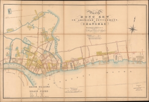
Plan of the Hong Kew (Hong Que.) or American Settlement, at Shanghae.
$19,000.00
Acquire
- Digital Map Information
- Suitable for large format printing
- File Size: 142.69 MB
- File Type: ZIP / TIFF
- ICC color profile embedded
- Delivered instantly via download link
A remarkable, rare, and highly detailed 1866 map of Hong Kew (Hongkou, 虹口区), or the American Concession in Shanghai - possibly the earliest known map to specifically illustrate the American Settlement. The map follows shortly after the formal establishment of the Concession and subsequent International Settlement in 1863 and details in manuscript the construction of subterranean drainage lines by the Shanghai Municipal Council. (more details)
First Municipal Council Maps - the origins of modern Shanghai.
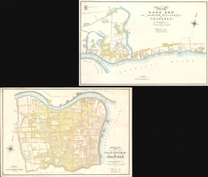
Plan of the English Settlement at Shanghae. / Plan of the Hong Kew (Hong Que.) or American Settlement, at Shanghae.
$45,000.00
Acquire
- Digital Map Information
- Suitable for large format printing
- Full resolution TIFF file
- ICC color profile embedded
- Delivered instantly via download link
The holy grail of Shanghai cartography, this 1866 map set is the most important, largest scale, and most beautiful early presentation of Shanghai. These are the first maps issued by the Shanghai Municipal Council, resulting from a landmark 1864-66 survey that followed the consolidation of the British Concession with the American Settlement. Their issue ended two decades of development lethargy and launched major urbanization and modernization projects that established Shanghai as the major gateway to China. As such, these maps, more than any other, represent the birth of Shanghai as a modern city. (more details)