
Tomigorō Ozaki

Tomigorō Ozaki (1822 - 1893) was a Japanese editor and printer active in Yokohama during the Meiji Period.
Yokohama when it was Japan's most cosmopolitan and industrialized city.
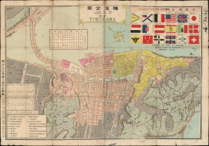
Map of Yokohama. / 横濱全圖
$750.00
Acquire
- Digital Map Information
- Suitable for large format printing
- Full resolution TIFF file
- ICC color profile embedded
- Delivered instantly via download link
This is a scarce 1892, or Meiji 25, Tomigorō Ozaki (尾崎富五郎) map of Yokohama, Japan, then Japan's primary international port. The map orients Yokohama to the northeast, with the city's shoreline at top. At the time, Yokohama was Japan's most international and industrialized city, with foreign settlements extending form the Bluff to Yokohama Chinatown. The cartographer stresses the internationality of the settlement, with a chart of flags at left center representing the largest foreign contingents in Yokohama. The vexillology chart features the flags of 18 countries, among them the United States, Persia, Rome (the Pope), and China. Despite clearly being uncomfortable with Latin characters, Ozaki has added English text here and there. He seems to have placed the capital 'D' shape backwards several times in the imprint below the flag chart. (more details)