
Pagano, Matteo

Matteo Pagano (1515-1588) was a Venetian woodcut artist and illustrator. While nothing is known about his early training, he was prolific and apparently successful. Among his more famous works is a 1556 eight-sheet woodcut of the procession of the Doge, in Venice. He produced a number of maps for various works, most notably the visually distinctive area maps appearing in Ramusio's Navigazioni et Viaggi. He is particularly noted for having published books of lace, needlework and embroidery designs, promoting needlework as an acceptable activity for virtuous women.
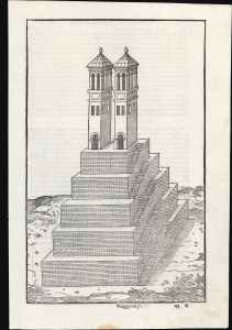
Contemporaneous View of Tenochtitlan's Great Temple.
[Untitiled Woodcut].
$450.00
Acquire
- Digital Map Information
- Suitable for large format printing
- File Size: 6.21 MB
- File Type: ZIP / TIFF
- ICC color profile embedded
- Delivered instantly via download link
This scarce 1565 woodcut, appearing in Giovanni Battista Ramusio's description of Mexico-Tenochtitlan, is among the earliest depictions of the main temple at the center of the capital of the Aztec empire. It is drawn from the report of an anonymous conquistador who accompanied Hernan Cortéz, whose account detailed the European view of the city for the first time. (more details)
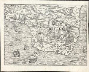
Earliest specific map of Brazil.
[Brasil].
$2,500.00
Acquire
- Digital Map Information
- Suitable for large format printing
- File Size: 13.62 MB
- File Type: ZIP / TIFF
- ICC color profile embedded
- Delivered instantly via download link
This is Giovanni Battista Ramusio's scarce 1565 map of Brazil, the first printed map to focus specifically on the area. It first appeared in Ramusio's 1556 Navigationi et Viaggi, the first collection of explorers' first-hand accounts of their travels. The woodcut represents the first specific glimpse, in print, of Brazil. While the map's geographical information is frequently credited to Giacomo Gastaldi (1500 - 1566), Ramusio's map is far more likely to have been drawn from his own French sources. (more details)
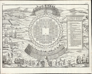
Capturing a glimpse of Cartier's meeting with the St. Lawrence Iroquois.
La Terra de Hochelaga Nella Nova Francia.
$4,500.00
Acquire
- Digital Map Information
- Suitable for large format printing
- File Size: 12.67 MB
- File Type: ZIP / TIFF
- ICC color profile embedded
- Delivered instantly via download link
This is an attractive example of the first map of 'Montreal,' in its scarce 1565 second edition. Its first 1556 printing was what Schwartz called 'The very first plan of a village in the United States or Canada,' and it is the earliest printed map to use the place name 'Monte Real,' which would become Montreal. Perhaps even more significantly, this woodcut is one of the only images from the Discovery Period of an intact indigenous town, reflecting its customs. (more details)