
Riley, Isaac

Isaac Riley (November 29, 1770 - March 14, 1824) was a New York City based book publisher and shipping merchant active in the early 19th century. Riley was born in Berlin, Connecticut. The earliest substantial refence we have found regarding Riley is from 1802, when he is recorded as a shipping agent based at 63 Pine Street, New York. It is not clear when he established his shipping business, or how it was run, but one report notes he owned sixteen vessels, suggesting considerable wealth. From at least 1805 to 1806 he ran Isaac Riley and Company, at 1 City-Hotel, Broadway, a printer and seller of legal books. This firm was sold in December 1806 to Brisban and Brannan. From roughly 1807 he had a new bookshop and printing office at the intersection of Wall Street and William Street, from which he published travel narratives, maps, and guides, as well as imported popular books from Europe. Riley was considered a major publisher, for a time touted as the 'largest in New York with a stock worth at least $400,000.' Nonetheless, when the War of 1812 led to a major recession, he, like many other publishers, was forced into bankruptcy. He recovered and was in business again by 1815. Around 1820 he relocated to Philadelphia, establishing his business there. He also was heavily invested in Maine real estate, where he is reported to have owned 'Ketcham' and 'Riley' townships. He established a colony of settlers from Philadelphia in Maine in 1823, traveling there with them. He died in Maine one year later, in 1824.
Earliest obtainable example of the influential Goerck-Mangin Plan of New York City - published while it was still relevant.
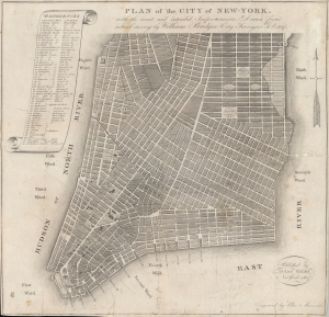
PLAN of the CITY OF NEW-YORK, with the recent and intended Improvements. New York, 1807.
$4,000.00
Acquire
- Digital Map Information
- Suitable for large format printing
- File Size: 10.32 MB
- File Type: ZIP / TIFF
- ICC color profile embedded
- Delivered instantly via download link
This important 1807 map of lower Manhattan, New York City, published by Isaac Riley, William Bridges, and Peter Maverick, is a most unusual piece with a confused and complex history. It predates the 1811 Commissioner's Plan, thus representing the definitive plan of New York City at the time of publication and exerting a profound influence on the developing street grid of Lower Manhattan. It is the earliest obtainable example of one of the most important founding cartographic documents relating to the development of New York's street grid - the Mangin-Goerck map. (more details)