
Vandermeren

Vandermeren (fl. c. 1838 - 1851) was a Belgian lithographer based in Brussels. His maintained offices at no. 1 Grande Rue au Beurre (today just Rue de Buerre). We have been unable to find any further trade of Vandermeren the printer, but the Almanach Royal et du Commerce de Belgique for 1838, and the Almanach du Commerce et de L'Industrie Belgium of 1851, both identify a Vandermeren at this address working as a lingerie seller and laundress. It is unclear how printing is related.
An early edition of a very rare map of Rome, Italy, highlighting both ancient and contemporary construction.
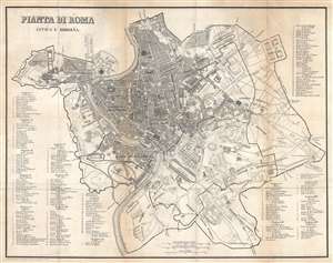
Pianta di Roma Antica e Moderna.
$500.00
Acquire
- Digital Map Information
- Suitable for large format printing
- DPI: 600
- File Size: 22.51 MB
- File Type: ZIP / TIFF
- ICC color profile embedded
- Delivered instantly via download link
This is an 1823 Vandermeren city map or plan of Rome, Italy. The map depicts the city from the Tiber River to the Circus Varianus and from the Piazza del Popolo to the Porta San Sebastiano, a gate along the Appian Way in the Aurelian Walls surrounding the city. Vatican City is also illustrated and is situated on the upper left near the Castel Sant'Angelo. Myriad locations throughout the city are labeled, including the Baths of Caracalla (labeled here as Terme Antoniniane), the Circus Maximus, and the Piazza di Spagna. Over 230 other sites, both ancient and modern, are numerically identified and correspond to fourteen different lists situated around the map itself. As the map is divided into fourteen different regions, these lists range from five sites to over forty. Numerous streets are identified, including the famous Appian Way (Via Appia). (more details)