
Vandermeren (sold)

Vandermeren (fl. c. 1838 - 1851) was a Belgian lithographer based in Brussels. His maintained offices at no. 1 Grande Rue au Beurre (today just Rue de Buerre). We have been unable to find any further trade of Vandermeren the printer, but the Almanach Royal et du Commerce de Belgique for 1838, and the Almanach du Commerce et de L'Industrie Belgium of 1851, both identify a Vandermeren at this address working as a lingerie seller and laundress. It is unclear how printing is related.
The Catacombs of Rome!
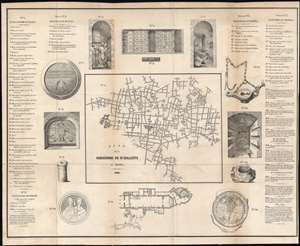
Plan de la Catacombe de St. Callixte a Rome.
sold
- Digital Map Information
- Suitable for large format printing
- DPI: 600
- File Size: 24.65 MB
- File Type: ZIP / TIFF
- ICC color profile embedded
- Delivered instantly via download link
This is a scarce 1848 plan or map of the Catacombs of Callixtus in Rome. The detailed map covers the cemetery complex noting its subterranean galleries and recesses for individual Tombs. Surrounding the map are illustrations of various artifacts and scenes, as well as a plan the Church of St. Sebastian at the Catacombs. A numerical list to the left and right of the map proper references numbered locations on the map. (more details)
Maps the crypts of ancient Popes and martyrs.
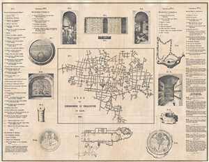
Plan der Catacombe St. Callixtus in Rom.
sold
- Digital Map Information
- Suitable for large format printing
- DPI: 300
- File Size: 12.69 MB
- File Type: ZIP / TIFF
- ICC color profile embedded
- Delivered instantly via download link
This is a scarce 1849 plan or map of the Catacombs of Callixtus in Rome. The detailed map covers the cemetery complex noting its subterranean galleries and recesses for individual Tombs. Surrounding the map are illustrations of various artifacts and scenes, as well as a plan the Church of St. Sebastian at the Catacombs. A numerical list to the left and right of the map proper references numbered locations on the map. (more details)