
Windwart, Heinrich

Heinrich Windwart (July 12, 1810 - April 30, 1881) was a German civil servant, revolutionary, medical doctor, and map publisher. He was born in Bavaria and studied at the University of Jena. He was heavily involved in the German Revolutions of 1848. When the revolutions were suppressed, he went into exile, first in Switzerland, then France, and ultimately, in 1853, to the United States. He initially settled in Baltimore, but moved to New York in the 1860s when his fellow German 'Forty-Eighter,' Franz Sigel (1824 - 1902), was elected Registrar of New York City, and offered him a clerk position. Windwart was one of several map publishers, the most famous of whom was John Bute Holmes, who was able to leverage cartographic skill to capitalize on the New York City transition from grand 18th century estates to the meticulously gridded and plotted structure of the Commissioner's Plan.
One of the earliest specific maps of the Lower East Side!
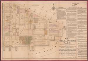
Map of the Corlear's Hook Farm, Situated in the present Seventh Ward…
$3,000.00
Acquire
- Digital Map Information
- Suitable for large format printing
- Full resolution TIFF file
- ICC color profile embedded
- Delivered instantly via download link
This is a rare 1881 Heinrich Windwart map of the New York City's Lower East Side, from Grand Street to the East River and from Montgomery to East Street, a region once known as the Corlear's Hook Farm. This is most likely the earliest specific published map of this part of New York. The meticulously compiled map illustrates multiple estates, including those of Nicholas Romayne, Nicholas Gouverneur, James Blanchard, Nicholas Cruger, Nicholas Low, Edward Laight, Stringham, Quackenbos, McComb, Roome, Willima Low, and the Gardner state. It illustrates the original waterline of Manhattan before the mid-19th century landfills. In addition, it shows underwater lands belonging to the Corporation of New York according to the legislative act of 1871. (more details)