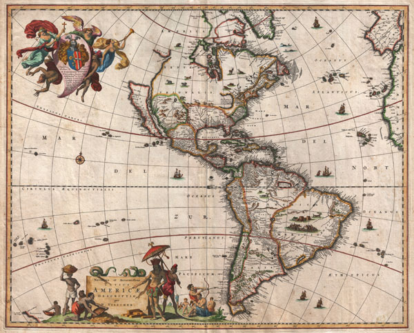
A striking first edition example of an extremely important and influential 1658 map of the Americas by Nicholas Janzoon Visscher. Covers all of the New World, the eastern extensions of Europe and Africa, and some Pacific Islands. This map proved extremely influential and, due to multiple pirated examples and reissues by competing Dutch map publishers, became the dominant representation of America well into the early 18th century. That said, the first edition is notably different from its successors on a number of points that firmly establish its preeminence as a cartographic milestone.
By far this map's most interesting cartographic elements deal with its unusual treatment of North America, with California represented as an island, the Great Lakes rendered as a single body of water open to the west, and Anian appearing far to the north.
The popularity of this map among prominent Dutch map publishers and cartographers of the late 17th century played a significant role in promoting the 'California as an Island' hypothesis. The concept of an insular California first appeared as a work of fiction in Garci Rodriguez de Montalvo's c. 1510 romance
Las Sergas de Esplandian, where he writes
Know, that on the right hand of the Indies there is an island called California very close to the side of the Terrestrial Paradise; and it is peopled by black women, without any man among them, for they live in the manner of Amazons.
Baja California was subsequently discovered in 1533 by Fortun Ximenez, who had been sent to the area by Hernan Cortez. When Cortez himself traveled to Baja, he must have had Montalvo's novel in mind, for he immediately claimed the 'Island of California' for the Spanish King. By the late 16th and early 17th century ample evidence had been amassed, through explorations of the region by Francisco de Ulloa, Hernando de Alarcon, and others, that California was in fact a peninsula. However, by this time other factors were in play. Francis Drake had sailed north and claimed 'New Albion' near modern day Washington or Vancouver for England. The Spanish thus needed to promote Cortez's claim on the 'Island of California' to preempt English claims on the western coast of North America. The significant influence of the Spanish crown on European cartographers caused a major resurgence of the Insular California theory. About half a century after this map was drawn Eusebio Kino, a Jesuit missionary, published his own 1705 account of travels overland from Mexico to California, establishing conclusively the peninsularity of California.
Visscher's rendering of the Great Lakes as a single body of water open to the west is of particular interest and is the most ephemeral element of this map, being updated in subsequent editions to reflect ongoing European exploration of the region. At first glance Visscher's great inland sea appears uncannily like Verazanno's Sea, a 16th century speculative body of water extending to the Pacific through the center of North America, which was no doubt a direct influence on the water form established here. Visscher describes his inland sea with the following Latin note:
Lacus iste quantum ex accolis colligi potuiy trecenta ut minimum miliaria en longitudinem pateat
This lake, as far as can be learned from the inhabitants, stretches at least three hundred miles in length
This is curiously identical to the text used by Jodocus Hondius on his world map of 1611 to describe his rendering of Verazanno's Sea. The next edition of this map would see this great inland sea replaced by more contemporary rendering of the Great Lakes taken from the explorations of La Salle, Hennepin, and others.
North of insular California we find the land of Anian, separated from the North American mainland by a narrow strait. Anian is generally considered to be an undiscovered land or strait in the extreme northwestern part of America. The earliest known reference to Anian is in the narratives of Marco Polo, who describes it as 'East of India.' In many early maps Anian appears as an imaginary proto-Bearing Strait, the Strait of Anian, separating Asia from America. Visscher's treatment of Anian is unusual. Here Anian appears both as a land and as a Strait, with the landmass of Anian situated to the west of the Strait of Anian and moreover undefined in its western extension, thus suggesting the possibility that Anian is in fact attached not to America, but to the Asian mainland?
In many period maps and literature, Anian is associated with the Northwest Passage, John Donn wrote 'Anyan if I go west by the North-West passage.' Visscher's treatment of the Northwest Passage is most curious, for he intentionally and fully closes the Hudson Bay by while leaving the Strait of Anian open at the eastern end, suggesting, possibly, that the only hope of discovering the legendary passage must come from the west.
In his rendering of the Rocky Mountains and other mountains to the west Visscher is remarkably prescient. Keeping in mind that when Visscher drew this map, the parts of America to the North of Mexico were almost entirely unexplored, it is of note that he accurately speculates on the Rocky Mountains, the Sierra Nevadas, the Great Basin between them, and, right there in the middle, a primitive impossible rendering of what might be interpreted as the Great Salt Lake. Though cartographically impossible given that the Great Salt Lake or the Great Basin would not be even tentatively explored until nearly 150 years later by Miera and Escalante, Visscher's rendering seems surprisingly accurate. Most likely this is little more than happenstance relating to Vissher's speculation on possible sources for the Colorado River, here labeled Rio del Norto.
Further south the cartography of South America is nearly as confused as that of North America. Though by this point in history, the general outlines of South America are well established by regular circumnavigations of the continent, the interior is entirely speculative. Even the great Amazon River is poorly and inaccurately rendered both regarding its general orientation and its connection with other large South American river systems, most notably the Paraguay. Visscher also recognizes two popular misconceptions regarding the mythical kingdoms of the Amazon, El Dorado and Xarayes.
In Visscher's time many Europeans believed that the most likely site of El Dorado was the mythical city of Manoa located here on the shores of the Lake Parima, near modern day Guyana, Venezuela, or northern Brazil. Manoa was first identified by Sr. Walter Raleigh in 1595. Raleigh does not visit the city of Manoa (which he believes is El Dorado) himself due to the onset of the rainy season, however he describes the city, based on indigenous accounts, as resting on a salt lake over 200 leagues wide. This lake, though no longer mapped as such, does have some basis in fact. Parts of the Amazon were at the time dominated by a large and powerful indigenous trading nation known as the Manoa. The Manoa traded the length and breadth of the Amazon. The onset of the rainy season inundated the great savannahs of the Rupununi, Takutu, and Rio Branco or Parima Rivers. This inundation briefly connected the Amazon and Orinoco river systems, opening an annual and well used trade route for the Manoans. The Manoans who traded with the Incans in the western Amazon, had access to gold mines on the western slopes of the Andes, and so, when Raleigh saw gold rich Indian traders arriving in Guyana, he made the natural assumption for a rapacious European in search of El Dorado. When he asked the Orinocans where the traders were from, they could only answer, 'Manoa.' Thus did Lake Parime or Parima and the city of Manoa begin to appear on maps in the early 17th century. The city of Manoa and Lake Parima would continue to be mapped in this area until about 1800.
Further south Visscher maps a large and prominent Laguna de Xarayes as the northern terminus of the Paraguay River. The Xarayes, a corruption of 'Xaraiés' meaning 'Masters of the River', were an indigenous people occupying what are today parts of Brazil's Matte Grosso and the Pantanal. When Spanish and Portuguese explorers first navigated the Paraguay River, as always in search of El Dorado, they encountered the vast Pantanal flood plain at the height of its annual inundation. Understandably misinterpreting the flood plain as a gigantic inland sea, they named it after the local inhabitants, the Xaraies. The Laguna de los Xarayes, accessible only through the Gate of Kings, almost immediately began to appear on early maps of the region and, at the same time, took on a legendary aspect. The Lac or Laguna Xarayes was often considered to be a gateway to the Amazon and the Kingdom of El Dorado. Here Visscher's rendering suggest exactly that, with a wide navigable Rio De La Plata leading directly to the Paraguay River and connecting clearly to the Lago de los Xarayes and thus the Amazon itself.
Visscher has dedicated this map to Cornelius Witsen, whose allegorical armorial crest, represented with victorious angels and a fallen devil appears in the upper left quadrant. Cornelis Jan Witsen (1605 - 1669) was an important figure in Dutch politics holding a post as governor of the Dutch West Indies Company and membership in the Dutch Admiralty. Cartographers typically dedicate maps to important figures in the hope that the maps will be recognized and patronized by the associated society. Witsen's position within the Dutch West Indian company may have lent considerable support to Visscher's interpretation of the Americas and have been a factor in this map's long popular publication run.
On the edges of the map other lands appear. In the extreme upper right quadrant, Europe seems to loom over the map as a whole, clearly suggesting Old World hegemony over the Americas. In the lower left, a protoform of New Zealand appears with Cape Maria van Diemen noted.
As a whole this map is a testament to the extraordinary skill of 17th century Dutch engravers. The detail throughout is astounding with tiny lettering that would give most modern laser printers a serious challenge. The crisp dark impression of this map also suggests that this is one of the earliest strikes from the first edition plate.
There is a significant dispute regarding the dating of this map. Tooley, in his
Mapping of America assigns conflicting dates of 1670 and 1690. Burden, a more contemporary map scholar, dates it to c. 1658. A number of factors suggest that Burden's date, rather than Tooley's is correct. Firstly, many of the cartographic elements of this map, especially Visscher's first edition treatment of the Great Lakes, suggests that the map must have predated Europeans knowledge of the late 17th century expeditions into America's interior. The quick revision of the Great Lakes regions in subsequent editions bears this out. Secondly, Visscher's choice to dedicate this map to Cornelius Witsen would have been foolish considering that Witsen died one year before the earliest Tooley publication date. Thirdly, the appearance of several pirated copies of this map in the 1660s and 1670s, all of which followed the second edition rendering of the Great Lakes, suggests a first edition publication date between 1657 and 1660.
Very good condition. Light soiling. Margin and centerfold wear.