This item has been sold, but you can get on the Waitlist to be notified if another example becomes available, or purchase a digital scan.

1744 Bellin Map of the Atlantic Ocean and the North American Colonies

Atlantic-bellin-1744
$150.00
Carte De L'Ocean Occidental et Partie De L'Amerique Septentrionale Dressee pour l'intelligence du Journal du V oyage. - Main View
Processing...

1744 Bellin Map of the Atlantic Ocean and the North American Colonies

Atlantic-bellin-1744

Elegant Map of the Atlantic, Showing Charlevoix' Voyage to and from North America.

Title


Carte De L'Ocean Occidental et Partie De L'Amerique Septentrionale Dressee pour l'intelligence du Journal du V oyage.
  1744 (dated)     9.5 x 15 in (24.13 x 38.1 cm)     1 : 30000000

Description


This is a 1744 Bellin map of the colonized regions of North America and the Caribbean Islands shown in relation to the coasts of Europe and Africa. It appeared in Pierre Francois Xavier de Charlevoix's 1744 Histoire et description generale de la Nouvelle France, one of the most comprehensive works on North America predating the French and Indian War. Charlevoix was a Jesuit missionary and traveler commissioned by the French Crown and the Duke of Orleans to explore French holdings in the Americas, particularly with a view towards finding a profitable route to the Pacific. Many hoped this in the network of rivers and lakes to the west of the Great Lakes, as suggested by earlier explorers and mapmakers such as Lahontan and De l'Isle.
Charlevoix's Journey
The map, as broad as it is, is intended to show the track of Charlevoix's voyages to and from North America. It shows his track from Rochefort to Newfoundland and then up the Saint Lawrence River, to Quebec City. His track then runs through Lakes Ontario, Erie, Huron, and Michigan before following the Illinois River to the Mississippi. It shows the author's shipwreck en route to Cuba from New Orleans, and then his successful attempt - reaching Cap Francois on Santo Domingo before re-crossing the Atlantic, reaching France at Le Havre.
What About Lake Superior?
The punctilious among our readers may note that the northernmost Great Lake appears to be left from Charlevoix's track: an interesting but perhaps unsurprising omission, given that one of Charlevoix's best-known contributions to cartography is his distinctive and spurious cartography of Lake Superior, with its four imaginary islands. These, though unnamed, do appear on this map, despite the author having not gone anywhere near them.
An Influential Work
Copies of the Histoire et Description Generale were to be found in the libraries of many 18th century luminaries, including Voltaire, Franklin, and Jefferson. Jefferson in particular admired Charlevoix's work, calling it 'a particularly useful species of reading.'
Publication History and Census
The Charlevoix' Histoire et Description Generale is well represented in institutional collections. OCLC lists copies of this separate map in perhaps a dozen institutional collections.

CartographerS


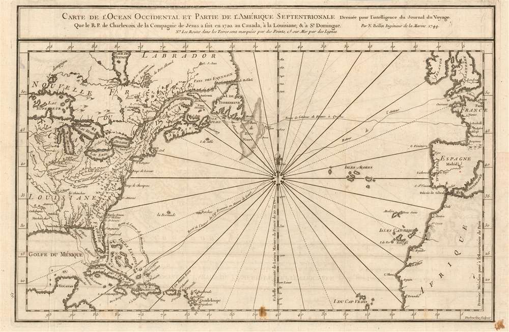
Jacques-Nicolas Bellin (1703 - March 21, 1772) was one of the most important cartographers of the 18th century. With a career spanning some 50 years, Bellin is best understood as geographe de cabinet and transitional mapmaker spanning the gap between 18th and early-19th century cartographic styles. His long career as Hydrographer and Ingénieur Hydrographe at the French Dépôt des cartes et plans de la Marine resulted in hundreds of high quality nautical charts of practically everywhere in the world. A true child of the Enlightenment Era, Bellin's work focuses on function and accuracy tending in the process to be less decorative than the earlier 17th and 18th century cartographic work. Unlike many of his contemporaries, Bellin was always careful to cite his references and his scholarly corpus consists of over 1400 articles on geography prepared for Diderot's Encyclopedie. Bellin, despite his extraordinary success, may not have enjoyed his work, which is described as "long, unpleasant, and hard." In addition to numerous maps and charts published during his lifetime, many of Bellin's maps were updated (or not) and published posthumously. He was succeeded as Ingénieur Hydrographe by his student, also a prolific and influential cartographer, Rigobert Bonne. More by this mapmaker...


Pierre François Xavier de Charlevoix, S.J. (October 24 or 29, 1682 – February 1, 1761) was a French Jesuit priest, traveller, and historian, often considered the first historian of New France. He is best known for his Histoire et description generale de la Nouvelle France, in spite of the work being primarily based upon the manuscripts compiled by Gaspard-Joseph Chaussegros de Lery, a French Canadian military engineer active throughout the Great Lakes region in the early 18th century. Charlevoix had been commissioned by the French Crown and the Duke of Orleans to explore French holdings in the Americas, primarily in order to find a profitable route to the Pacific - perhaps via the rivers and lakes west of the Great Lakes suggested by De l'Isle and Lahontan. Charlevoix was not above inventing discoveries: the imaginary islands in Lake Superior that appear frequently in 18th century maps can be laid at Charlevoix's feet, the results of his efforts to flatter his patrons (and patron saints.) Learn More...

Source


Charlevoix, Pierre Francois Xavier de, Histoire et description generale de la Nouvelle France, avec le journal historique d'un voyage fait par ordre du roi dans l'Amerique septentrionnale, (Paris: Chez Rollin) 1744.        

Condition


Very good condition. Margin extended at insertion point, few small stains.