An extraordinary find, this is the best early 20th-century large-format wall map of Denver, Colorado, here with extensive manuscript additions relating to railroad development. This is the only known example, made even more unique for its comprehensive manuscript overview of early railroad development in Denver.
A Closer Look
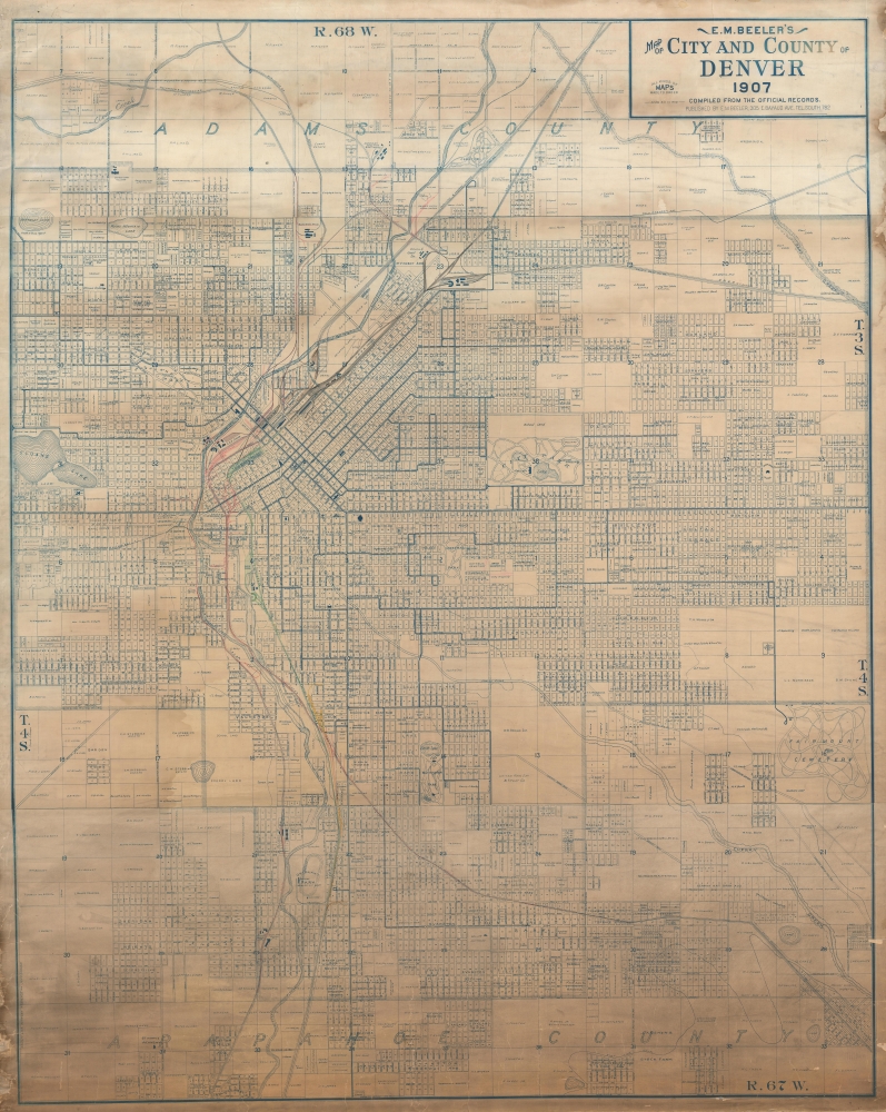
Issued by Edwin Mead Beeler in 1907, the present map is a diazo print. It is without copyright, suggesting it is a made-to-order product based upon Beeler's work for the city of Denver Board of Public Works. Appropriately, trams and train lines appear throughout the city in an expansive network, giving a comprehensive overview of the complex network of private railroad companies then operating in Denver.
This is a highly detailed map illustrating Denver's political, commercial, and urban development to 1907. Centered on Cheeseman Park, the map extends from Clearwater Creek to Fairmount Cemetery / Sullivan and from Sheridan Heights to Irvington and Schermerhorn Place. Throughout, the map notes urbanized and unurbanized zones, including the names of investment companies and private land owners - particularly in the undeveloped districts. It further illustrates the various additions, with blocks identified numerically. The underground channel of the South Platte River is also identified.Railroad Lines in Manuscript
Significantly, railroad lines have been added in meticulous manuscript. Color coding distinguishes multiple railroad networks, most of which converge on Union Station: Colorado and Southern (Red), Burlington and Missouri (Brown), Denver and Rio Grande (Green), Union Pacific (Black), Denver and Santa Fe (Yellow), and the Northwestern Terminal Railroad (Blue). The additions give an overview of the railroad development in Denver at a time when competing services fought to develop their parts of the city.Some Context
Beeler moved to Colorado in 1896 or 1897. It is unclear where he obtained training as a draftsman and civil engineer, but he began working for the Denver Board of Public Works in 1901, helping to plan and construct a city-wide tram system. His earliest maps appear around 1904 and are private enterprise works produced by leveraging his insider cartographic access to official maps and documents. Initially, he produced very few maps. We have identified one commercial publication in 1904, his Latest Map of the City of Denver. In 1905, a medium-format internal-use map detailing tramways was published in conjunction with the Smith-Brooks Company and the Denver City Tramway. In the same year, 1905, there is another map surviving in only one example at the Denver Public Library (CG4314 .D4 1905 .B4). We have yet to be able to acquire an image of that map or any substantial information about it, other than that it deals with the city's sewers. That map is on the same scale as the current 1907 map and likely served as a precursor to this more commercially minded piece.Moving Toward a Commercial Map
We suspect from the above that Beeler may have been involved with the construction of Denver's public sewers between 1905 and 1906. In this capacity, he produced the above-noted 1905 (Denver Public Library, CG4314 .D4 1905 .B4) map at an unprecedented scale of 6 miles to the inch. He recognized he had the best available map of Denver and sought to capitalize on it.
Beeler began, initially, to produce small numbers of white print (reverse blueprint or cyanotype) maps to order, as stated near the title of this map. The present map is the only such to survive. The natural limitations of the whiteprint technique generally mean that very few copies could be produced - although they could be produced very quickly and economically. As such, it is safe to assume that this map is a made-to-order specialty item, of which only one or two are likely to have been compiled.
Six years later, in 1913, Beeler produced Beeler's Official Map of the City and County of Denver, on the same scale of 6 miles to the inch, using the present map as a template. This was a far more commercial production, copyrighted twice in 1913, well-advertised in Denver publications, and published in partnership with the prominent Denver map publisher George Clason. This leads us to believe that Beeler may have acquired private financial backing via Clason or another investor.Diazo Print or Whiteprint
The diazo print (whiteprint or diazo for short) is a photo reproductive technique best understood as a reverse cyanotype or blueprint. The process yields distinctive blue lines on white paper. Like cyanotypes, the diazo process gained popularity in architecture circles, where it was a simple and effective way to duplicate documents in the field. The earliest diazotypes appeared around 1880 and were adopted for military and field cartographic use from about 1895. The diazo process was commercialized in 1923 when the German firm Kalle and Company developed Ozalid, a patented diazo paper that made diazotyping even easier. By the 1950s, it supplemented cyanotypes as the preferred reprographic technique for technical drawings.Publication History and Census
This map, as dated, was produced, probably to order, by Edwin Mead Beeler in 1907. This is the only known example. Diazo printing suggests that only a few could have been produced, as the technique has natural limitations, so this is most likely a unique piece.
Cartographer
Edwin Mead Beeler (July 2, 1871 - October 18, 1931) was an American mapmaker, surveyor, businessman, and civil engineer active in Denver, Colorado and New York City, in the early late 19th and 20th centuries. Beeler was born in Cincinnati, Ohio. As a young man he worked as a driver in Cincinnati before taking a clerkship at the Cincinnati offices of the Northern Assurance Company. He remained in this position until about 1895, when he became a 'manufacturing agent.' In search of a better life in the west, he relocated to Denver, Colorado in 1896 or 1897, where he appears in the City Directory as a draughtsman and civil engineer in the employ of the city's Board of Public Works. Given his later career and the content on some of his maps, we suspect Beeler was working on the Denver's tramways. Beeler's earliest maps appear around 1904, all of which focus on Denver. In a rare map, surviving in a single known example, from 1907, he advertises that he makes 'All Kinds of Maps to Order', from his offices at 305 E. Bayaud St. Some are clearly private enterprise, as they contain advertising, others are official-looking maps. He formally established the 'Beeler Map Company' in 1913, when he copyrighted his Official Map of the City and County of Denver, a large format wall map of Denver issued in whiteprint or reverse cyanotype, possibly issued with the support of Denver mapmaker George Clason. Sometime between 1921 and 1930 he relocated to New York City, presumably to retire, but in the 1930s census he is still listed as a 'Street Car Engineer.' Beeler died in 1931 and is buried in Scarsdale, Westchester, New York. More by this mapmaker...
Good. Some edge wear and verso reinforcement. Some discoloration to paper in lower quadrants.
OCLC 1008963719.