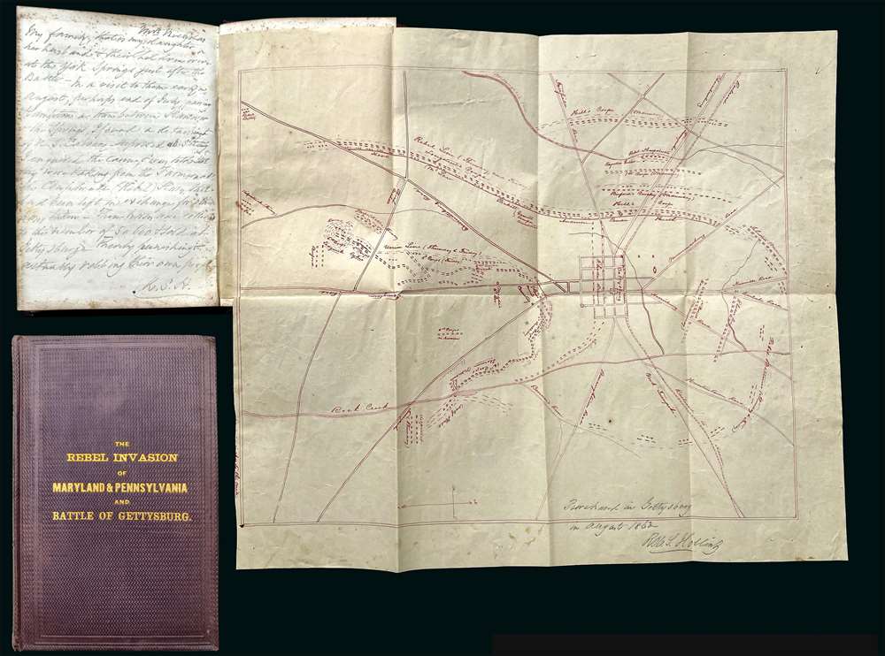
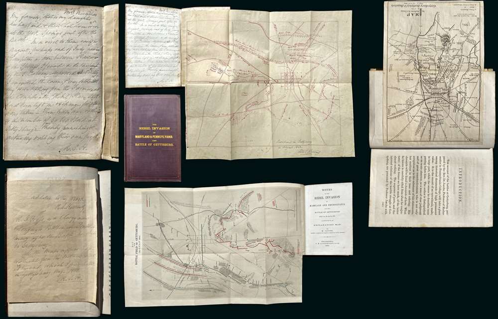
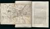
A remarkable discovery, this is a fine example of Michael Jacob's scarce 1864 book on the Confederate invasion of Pennsylvania and the Battle of Gettysburg. While the book itself is uncommon and interesting, the most exciting aspects of the piece are manuscript notes, tipped-in maps, and annotations, by railroad magnate Robert S. Hollins, describing the Battle of Gettysburg and its aftermath. Along with the usual map that accompanies this book, the present example contains additional two tipped-in maps. One a unique manuscript dated to August of 1863, making it one of the earliest known maps of the battle, drawn just days after the conflict. The other is a small but previously unknown printed map of the town and battlefield published by Andrew J. Cross, a clergyman of Baltimore. The extensive manuscript notes, by Baltimore railroad man Robert S. Hollins, describe horse thievery by New Jersey soldiers from Pennsylvania farmers shortly after the battle as well as the acquisition of the maps.
The Manuscript Map
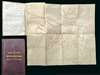
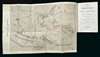
The manuscript map appended to the back of the book details the Battle of Gettysburg (July 1 - 3, 1863) in considerable detail. The map is oriented to the west with the town of Gettysburg at center. Roads and both Union and Confederate troop positions are labeled throughout. Like later maps by Bachelder, the cartographer here attempts to record all three days of the battle by making notes of unit positions at different times.
A note appearing in the lower right reads 'Purchased in Gettysburg in August 1863 by Rob. S. Hollins', which would mark it as among the earliest known illustrations of the battle. The manuscript lettering on the map is similar in style to other writing throughout the book by Hollins and his own note on the map, suggesting that by 'purchased,' he means he paid for the right to make a copy. The workmanship of the map is careful but lacks the meticulousness of a trained military surveyor, leading us to believe that the copy work is in Hollins's own hand. Using contemporaneous newspaper articles, we have been able to successfully place Hollins in the Gettysburg vicinity in late July / early August of 1863, when the annotations suggest he acquired the Map (
York Gazette, August 18, 1863).
Sources of the Manuscript Map
After the Battle of Gettysburg, work immediately commenced in recording the historic event. Civilians like John B. Bachelder (1825 - 1894) were on-site just days after the battle, interviewing soldiers and conducting surveys. The military, too, ordered immediate maps the battle produced. Gouverneur Kemble Warren (1830 - 1882), a civil engineer and brigadier general during the battle, commanded the staff surveyor Emmor B. Cope to begin a meticulous survey. Cope's initial survey was compiled hastily from horseback. Cope incorporated data from the 1858 G. M. Hopkins general map of Adams County, Pennsylvania, at the time the best map of the area used by commanders on both sides of the conflict. This map survives in the National Archives (RG 77, Civil Works Map File, E 72 (1)).
The Cope survey was significant as the first map to show troop placements during the battle. It has several unique characteristics. First, it is oriented to the west, like the present map, and second, it is oval. Cope's original manuscript survives, as do several working field photo-reprographic productions, and it was later reproduced in chromolithograph by Thomas Ditterline. Given the orientation of the map, the fact that Cope's manuscript would have been the best and only map of the field of battle available in late July 1863, and a comparison of place names, we believe the presently offered map to be an early civilian manuscript copy of the Cope manuscript, or possibly variations thereof.
While we believe the present map, which we will from here forward refer to as the Hollins Map, to have been derived from the Cope manuscript now at the National Archives, it is not a slavish copy. The work is done hastily and omits details that would have been insignificant to the battle, such as the locations of private homes, mills, and smithies, etc. derived from the 1858 Hopkins map. It also omits extensive topographical treatment save for features like Round Top, which were significant to the battle. The Hollins map also adds a novel element reminiscent of Bachelder's Gettysburg work in that it attempts to illustrate all three days of the battle on a single sheet. While Bachelder incorporates an ingenious color-coding system to define troop placements over time, Hollins merely annotates troop positions with dates. When Hollins visited Gettysburg, Bachelder's detailed survey of the battle would not yet have been available or even complete, which begs the question, 'who inspired who?' There can be little doubt that in the rough days following the battle, cartographers, historians, and surveyors, both military and civilian, worked together and shared information.
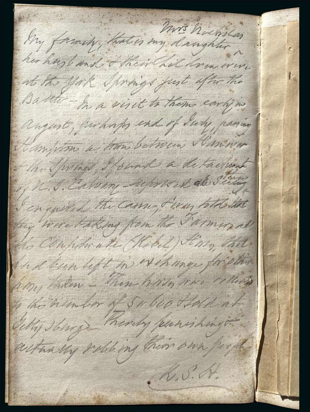
Manuscript Note on Horse Thievery
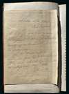
At the back of the volume, opposite the manuscript map, there is an extensive note in Hollins's hand detailing an event that occurred on his August 1863 trip to York, PA - which would have taken him through Gettysburg.
My family, that is my daughter, Mrs. Nicholas, her husband and their children were at the York Springs just after the Battle - In a visit to them early in August, perhaps end of July, passing Hampton a town between Hanover and the Springs, I found a detachment of N.J. Cavalry - Surprised at seeing them I enquired their cause, I was told that they were taking from the farmers all the Confederate (Rebel) horses that had been left in exchange for other horses taken - Those horses were collected to the number of 5 or 600 and sold at Gettysburg. Thereby punishing and actually robbing their own people. (Manuscript note by Robert S. Hollins)
This describes known practices. Officers and cavalry soldiers of the retreating Confederate army stopped at local farms where they pressed farmers to exchange their wounded and worn out mounts for fresh ones. Once the Confederates had fully retreated, Union soldiers seized these 'Confederate' horses from the farmers, claiming them, like the detritus of the battlefield, as the spoils of war, while at the same time punishing the hapless farmers for 'conspiring' with the enemy. The horses were taken to Gettysburg where they were sold to anyone with means.
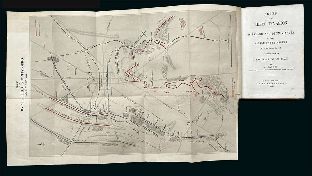
The Cross Map
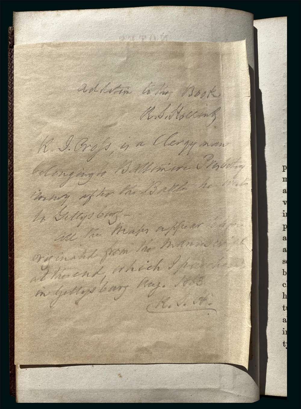
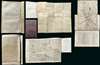
Tipped into the front of the book, opposite the title page, is the previously unrecorded Andrew B. Cross map of Gettysburg illustrating the 'Battlefield and Hospitals.' On the back of the Cross map, there is an annotation describing Cross and his presence at Gettysburg,
A. B. Cross is a Clergyman belonging to Baltimore Presbyterian after the Battle he went to Gettysburg. All the maps appear to have originated from the manuscript at the end, which I purchased in Gettysburg Aug. 1863 R.S.H.
Cross did, in fact, arrive in Gettysburg shortly after the battle as part of the Christian Commission delegation, which set up hospitals and provided clergical services to the wounded Union soldiers. Cross and Hollins also appear to have known one another well and traveled in the same elite Baltimore circles - perhaps explaining the presence of the map in Hollins' book. When Hollins died, it was Cross who delivered the funerary eulogy, hinting at a close relationship.
Andrew Boyd Cross (November 12, 1810 - 1889) was a controversial Presbyterian minister active in Baltimore during the middle to late 19th century. Cross was born in Baltimore to a wealthy lumber family and as a young man studied at Dr. Craig's Academy. In 1827, he underwent a religious revival under Rev. John Breckinridge, subsequently joining the Second Presbyterian Church of Baltimore. He briefly studied at Dickinson College in Carlisle, Pennsylvania, before transferring to the Princeton Theological Seminary, graduating in 1834. Cross dedicated his life to anti-Catholic and reformist causes, including temperance, abolition, the Liberia colonization movement, public schools, and nativist movements. In 1856, Cross lobbied the Maryland State Legislature to pass a law making convents illegal, earning him the enmity of local Catholics. During the Civil War, Cross strongly supported Union forces and served as a member of the Christian Commission, providing medical, social, and religious services to Union soldiers - leading to the publication of his map (appended to book) of the Battle of Gettysburg and the hospitals that appeared after the battle.
This small map, which is otherwise unknown, closely resembles the manuscript at the back of the book, but is more traditionally oriented and contains additional details regarding the many makeshift hospitals that appeared after the battle - note Camp Letterman, here identified as 'General Hospital.' One can only speculate, like Hollins, that they were derived from the same source.
The Author of the Annotations
Robert S. Hollins (1797 - August 2, 1882) was an American railroad man of considerable wealth active in Baltimore in the mid to late 19th century. Hollins was born in Maryland and resided at 121 Park Avenue, Baltimore. He was the secretary of the Northern Central Railroad from its founding in 1854 to his retirement in 1877. He also served as secretary of the Wrightsville, York, and Gettysburg Railroad Company, which under financial duress was partially acquired by the Northern Central. A newspaper article, dating to August 17, 1863, definitively places Hollins in York, PA, as described in the annotations, for a meeting of the railroad's stockholders (
York Gazette, August 18, 1863). His daughter, Jane Nicholas (18?? - January 11, 1890), mentioned in the annotations, married Wilson Norborne Nicholas (1819 - 1871) in 1849. Hollins was the brother of John Smith Hollins, a former mayor of Baltimore, and the naval officer Commodore George N. Hollins.
Utter Speculation
The combination of history, study, the maps, and the annotations lends itself to some speculation on our part. In late July, shortly after the battle, Hollins and his family traveled from Baltimore to York, Pennsylvania, for an August 17 shareholder meeting of the Wrightsville, York, and Gettysburg Railroad Company, of which he was a major stakeholder. This route stops in Gettysburg. Curious about the battle, Hollins met Cope or possibly Warren and paid someone who allowed him to make a copy of the map, to which he added detailed information regarding troop movements and positions. Moving on towards York, he then encountered New Jersey soldiers 'seizing' Confederate mounts from Pennsylvania farmers. He returned to Baltimore but remained interested in the battle, acquiring Jacobs' book about the battle, which was published a year later in 1864. To this book, he appended his manuscript map, and another small map, made by his friend Cross, noting their resemblance to one another. He also, around this time, added notes regarding his own experiences in the aftermath of the battle.
The Battle of Gettysburg
Fought from July 1st through the 3rd, 1863, the Battle of Gettysburg was the defining moment of the American Civil War (1861 - 1865). The Confederacy began the war by advancing aggressively and successfully under the brilliant generalship of Maj. General Robert E. Lee (1807 - 1870). Buoyed by his May 1863 successes at the Battle of Chancellorsville (April 30 - May 6, 1863), Lee launched a grand invasion of Pennsylvania, intending to push as far as Harrisburg, or potentially Philadelphia. The Union and Confederate forces first engaged on July 1 of 1863. The Confederates met with some initial success, seizing weakly defended but strategic ridges before reaching a stalemate. The Confederates decided to break the stalemate with an aggressive charge on the well-fortified Union position of Cemetery Ridge. Pickett's Charge, named after its leader, the Confederate Maj. Gen. George E. Pickett (1825 - 1875), was a disaster, incurring heavy Confederate losses and turning the tide of the battle. In subsequent engagements, Union forces prevailed again and again, forcing the Confederate army into a torturous retreat to Virginia. The Battle of Gettysburg resulted in between 46,000 and 51,000 casualties, proving the costliest single battle in U.S. history. In the aftermath of the battle, on November 19, President Abraham Lincoln (1809 - 1865) issued the historic Gettysburg Address, redefining the purpose of the war. Pickett's Charge proved to be the Confederate high-water mark. Not only did the Confederacy lose the Battle of Gettysburg, but from this point forward, they also began to lose the war.
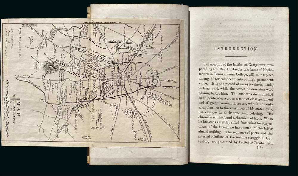
Publication History and Census
The Michael Jacobs book,
The Rebel Invasion of Maryland and Pennsylvania is scarce, but does appear on the market from time to time and is present in many institutional collections. The manuscript map is unique, as are the manuscript annotations. The Cross map at the front of the book is here-to-fore unknown (not in Stepheson, but Cross' map of Richmond and Petersburg is), but was engraved and printed by the A. Hoen firm of Baltimore. It is undated, but presumably 1863-4. On the whole, this book, with its manuscript annotations and appended maps, is a remarkable piece of Civil War History.
Very good. Tight original binding clean (7.5 x 4.75 in). Includes original map (17.5 x 11.5 in) by Jacobs, which has a fold repair. In addition, there are two maps not included in the original publication that have been tipped in. A manuscript map (13 x 14.5) in red ink in the back, acquired in Gettysburg in 1863, and opposite the title page a printed map (8 x 5.5 in) by Andrew Cross. Two manuscript annotations describing the manuscript maps and events that occurred shortly after the battle. Manuscript map has a small tear where originally attached to binder.