This copy is copyright protected.
Copyright © 2024 Geographicus Rare Antique Maps
1859 Sonnenstern / Gehüchte Map of Guatemala - first national map of Guatemala!
Guatemala-sonnenstern-1859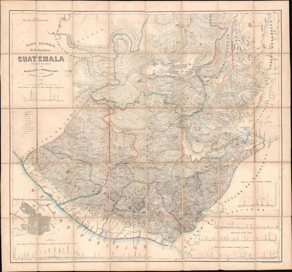

the national government commissioned a new territorial map [the Sonnenstern-Gehüchte map] based on the mapmakers own on-the-ground travels to verify and measure with modern instruments the latitude and longitude of cities, rivers, and mountains. At first this meant partial re-colonization and reliance on foreign expertise to collect, analyze and print data in cartographic form.In essence, she argues that, although composed by European immigrants to Guatemala, and published in New York, the Sonnenstern-Gehüchte map is an inherently Guatemalan production, liberated from the colonial interests of European nations, conceived and developed internally, and arguing for Guatemalan (as Carrera saw them) interests.
all (existing) maps of the country were bad…they were not the results of measurements as they ought to be, but compositions made in offices, from a mass of false data, and from these, each more incorrect than the other.Gehüchte's subsequent mapping of Guatemala was carried out in a half-official half-private capacity. The meticulously checked and rechecked existing surveys while at the same time traveling the country conducting new survey work and taking astronomical observations. While some elements of this mega-project were done in an official capacity, Gehüchte, exhibiting missionary zeal, invested his own resources to compile accurate cartographic data well beyond any financial considerations.
Maximilian von Sonnenstern (1819 - 1895) was a German born businessman, civil engineer, cartographer, and surveyor active in New York, Guatemala, El Salvador, and Nicaragua during the middle part of the 19th century. Sonnenstern was born in Stuttgart, Germany, and is reported to be he illegitimate scion of the royal family of Württemberg. He received military training in Germany, mastering surveying, draftsmanship, and engineering, before serving as on officer in the Württemberg army. He was active during Revolution of 1848 and was subsequently forced to flee Germany, settling in New York in 1848 or 1849. Seeking a brighter future, Sonnenstern relocated to Central American in 1855. He was not alone in doing so. In fact, there is a tradition of German engineers relocating to Central America in the mid-19th century. With political unrest at home in Germany and the broad expectation that an Atlantic-Pacific Canal was about to be built, and new political entities popping up, Central America was a dangerous yet appealing option for an enterprising and skilled engineer. Sonnenstern initially settled in Nicaragua, at the time considered the most likely candidate for an interoceanic canal, where his engineering skills earned him an official position. His work took him throughout Nicaragua as well as nearby El Salvador and Guatemala, where he met and befriended both political figures and other European ex-pat engineers. In 1858, he received an exclusive privilege to manufacture paper in the Republic of Guatemala - suggesting close ties with that country's political elite. Soon after he was commissioned to compile the first national map of Guatemala. Sometime around 1858 - 1859 he returned to the New York to manage the publication of his two most important maps, state sponsored maps of the new Central American republics of El Salvador and Guatemala. He returned to Nicaragua shortly thereafter, continuing in his state position and naturalizing as a Nicaraguan citizen in 1869. In 1874, Sonnenstern published Report of the Nicaragua Route for an Interoceanic Ship Canal, which was commissioned by the Nicaraguan minister of public works and published in the United States by the United States Coast and Geodetic Survey. Sonnenstern served in his Nicaraguan post until his death, at the age of 76. He was eulogized as a hero of the Nicaraguan republic, with cartographic legacy encompassing not just Nicaragua, but three Central American nations. We are aware four maps that can be attributed to Sonnenstern: Mapa General de la Republic de Guatemala (Kraetzer, New York, 1859) Mapa general de la Republica de Salvador (Kraetzer, New York, 1859), Mapa de las Republicas de America Central (London, 1860), Mapa de la Republica de Nicaragua (New York, 1858 and 1859, and Paris, 1863). More by this mapmaker...
Augustin van de Gehüchte (fl. c. 1841 - 1860) was a Belgian surveyor and civil engineer active in Guatemala during the middle part of the 19th century. Little is known of Gehüchte's early years. He was most likely born in Belgium. His cartographic skills suggests military training. In 1841, he was sent to Belgium as part of the Compagnie Belge, a short lived Belgian colonial venture in Guatemala (noted on this map). After Guatemalan independence under Rafael Carrera Turcios (1814 - 1865), Gehüchte, as the country's only skilled surveyor and mapmaker, became instrumental in the development of the country, surveying roads, private land exchanges, and national borders. Learn More...
Ludwig Gustav Adolph Kraetzer (March 21, 1822 - October 21, 1901), generally publishing as Gustav Kraetzer, was a German-American lithographer and printer based in New York. Kraetzer was born in Mainz, Rheinland-Pfalz, Germany. He was involved with the Revolutions of 1848 and following the suppression was forced to flee Germany. He arrived in the United States, coming through New York, in October of 1850 on the ship William Tell. He became a U.S. citizen several years later in 1856. When Kraetzer arrived in New York it has already a master lithographer, having trained in Germany. His printing concern was widely published and includes decorative prints, views, business products, advertising, and maps. Kraetzer maintained offices on Sheffield Avenue in East New York, Long Island, now part of Brooklyn. Learn More...
Jacob Rau (1821 - ????) was a New York based engraver and lithographer who advertised himself as a 'practical lithographer.' He was born in Holstein, Germany and emigrated to New York between 1848 an 1850, likely fleeting repercussions from involvement in the Revolutions of 1848, making him a 48er. He maintained offices at 333 Broadway and later at 381 Pearl Street, where he published works in association with others from the German-American immigrant community, most prominent among them Gustav Kraetzer (1822 - 1901). Rau published maps, views, advertising, and books. He has some association with the Nicaraguan-German civil engineer Maximilian von Sonnenstern (1819 - 1895), also a 48er from Württemberg, for whom he published several seminal maps. From 1864 he was associated with Edward Valois, also a lithographer, with whom he published under the imprint of 'Valois and Rau.' His production seems to have stopped in the late 1860s. Learn More...
Copyright © 2024 Geographicus Rare Antique Maps | Geographicus Rare Antique Maps
This copy is copyright protected.
Copyright © 2024 Geographicus Rare Antique Maps