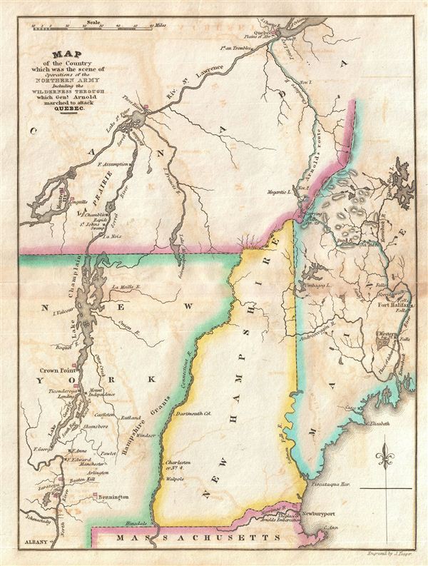
This is a rare map of New York, Vermont, New Hampshire, Maine and Quebec during the American Revolutionary War issued for John Marshall's 1832 edition of the Life of Washington. The map covers the strategically vital Hudson Valley – St. Lawrence corridor between Albany, New York and Quebec City, Canada. From east to west it covers from Montreal and Albany to Maine's' Kennebec River. Various rivers, major roads, and the sites of important battles are noted.
Marshall prepared this map to illustrate the important Hudson Valley theater of the American Revolutionary War. Specifically this map documents the Battles of Bennington, Saratoga, Still Water, Ticonderoga, Crown Point, Montreal, Trois-Riveres, and Quebec. Control of the Hudson River Valley and the St. Lawrence Corridor was hotly contested throughout the war. Following several disastrous attempts by the Continental Militia to seize control of Quebec and Montreal the focus of the regional war shifted to the strategically positioned Fort Ticonderoga, which effectively controlled access to the Hudson and Lake Champlain. Fort Ticonderoga changed hands several time during the war but control of the Hudson resolved to the Continental forces following the defeat of British General Burgoyne at the Battle of Saratoga. This victory was one of the great turning points of the American Revolutionary War.
This map appeared in atlas volume attached to the 1832 edition of John Marshall's seminal work, The Life of Washington. Marshall composed the five volume biography between 1805 and 1807 and based the work on original papers and records provided by the president's own family. The earliest partial edition of the The Life of Washington appeared in 1824 as A History of the American Colonies. In 1832 Marshall revised and abridged the original voluminous work to just two volumes and some 400 pages – from which this map was extracted. The maps of the 1832 edition are notable and desirable in that, unlike the original edition, most had hand applied color work.
CartographerS
John Marshall (September 24, 1755 - July 6, 1835) was the longest-serving Chief Justice of the United States (1801-35). Marshall's court opinions helped establish the basis for American constitutional law and made the Supreme Court of the United States a coequal branch of government along with the legislative and executive branches. Previously, Marshall had been a leader of the Federalist Party in Virginia and served in the United States House of Representatives from 1799 to 1800. He was Secretary of State under President John Adams from 1800 to 1801. Between 1805 and 1807 Marshall published an influential five-volume biography of George Washington. Marshall's Life of Washington was based on records and papers provided to him by the late president's family. The work reflected Marshall's Federalist principles, and is frequently praised by historians for its accuracy and well-reasoned judgments. More by this mapmaker...
Joseph Yeager (1792 - 1859) was a Philadelphia based engraver active in the first half of the 19th century. Yeager was trained early on as an engraver with works appearing as early as 1808 and 1809, at just 16 years of age. By the time he reached adulthood, Yeager had become one of the top engravers in Philadelphia, where he maintained offices from 1816 to 1845. He is responsible for numerous maps and views including the map plates for Carey and Lea's American Atlas and the map plates for the 1832 edition of John Marshall's Life of Washington, and a stunning illustration of the Battle of New Orleans. Yeager also published numerous children's books and, in time, became the president of a railroad. Learn More...
Source
Marshall, J., Atlas to Marshall's Life of Washington, (J. Crissy, Philadelphia) 1832.
Very good. Offsetting. Original centerfold exhibits light toning. Blank on verso.
Rumsey 2559.006 (1807 edition). Howes, W., U.S.iana (1650-1950): A Selective Bibliography in which are Described 11,620 Uncommon and Siginficant Books Relating to the Continental Portion of the United States, M317.