This item has been sold, but you can get on the Waitlist to be notified if another example becomes available, or purchase a digital scan.

1900 Garnier Pocket Map or Plan of Paris, France ( Eiffel Tower )

Paris-garnier-1900
$150.00
Nouveau Paris Monumental itineraire Pratique de L’Etranger Dans Paris. - Main View
Processing...

1900 Garnier Pocket Map or Plan of Paris, France ( Eiffel Tower )

Paris-garnier-1900


Title


Nouveau Paris Monumental itineraire Pratique de L’Etranger Dans Paris.
  1900 (undated)     21 x 27 in (53.34 x 68.58 cm)

Description


This rare c. 1900 pocket map of Paris, France, combines the virtues of a map and a view. Covers the old walled city of Paris and surrounding areas. Paris proper is colored in appealing pastels and exhibits more 'map-like' qualities in the layout of the streets, trains, and bridges. Important buildings and monuments are shown in profile. These include the Eiffel Tower, The Arc de Triomphe and the Opera, among hundreds of others. The regions outside the walled city are mostly in view format, with a horizon in at top and trees, buildings, and bridges shown in profile. An altogether marvelous decorative map and one of the first tourist maps to show the Eiffel Tower. Issued with its accompanying guide, bound in red linen. Features 13 pages of text with guides to museums, hotels, shops, and other advertisements. Engraved by L. Poulmaire, printed by Dufrenoy, and published in Paris by Librairie Garnier Frères.

Cartographer


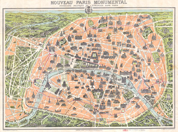
Garnier Frères (1833 - June, 1983) was a large and prominent publishing house and bookstore based in Paris, France. The publishing firm was founded in 1833 by the brothers Auguste (1812 - 1887) and Hippolyte Garnier (1815 or 1816 – 1859, photo at right). Their younger brother Pierre-Auguste (1807 – 1899) also joined the firm. Yet another brother, Baptiste-Louis Garnier (1822 - 1893) joined in 1844. The popular Paris bookshop, located in the arcades of the Palais-Royal in the gallery Peristyle Montpensier, followed shortly after in 1838. They opened another location in 1853 in the former government hotel, at the corner of rue de Lille and rue des Saints-Pères. The firm prospered through the publication of low cost editions French classics. Their corpus of work includes maps, guides, novels, historical works, and essays. In June of 1983 the firm filed for bankruptcy and their assents were taken over by Presses de la Cité, a subsidiary of InfoMédia, which was itself liquidated in 2000. More by this mapmaker...

Source


Independent Issue.    

Condition


Very good condition. Folds into original ren linen binder.

References


Bibliographie Nationale Francaise, 06-02085 . DL 0500791 (BN, Cartes et plans) . Ge FF 22109. CPL Opaline 337777.