This item has been sold, but you can get on the Waitlist to be notified if another example becomes available, or purchase a digital scan.

1652 Merian Panoramic View or Map of Rome, Italy

Roma-merian-1642
$1,250.00
Roma. - Main View
Processing...

1652 Merian Panoramic View or Map of Rome, Italy

Roma-merian-1642

Spectacular late Renaissance Map and View of Rome.

Title


Roma.
  1642 (undated)     12.5 x 28.5 in (31.75 x 72.39 cm)

Description


An important and stunning c. 1642 bird's eye view and map of Rome by Matthus Merian. Merian's panoramic view of Rome, based on the eastward oriented model established in 1593 by Antonio Tempesta, reveals the city at the height of the Italian Renaissance. This map follows shortly after Pope Sixtus the Fifth's ambitious civic redesign of Rome and yet predates the massive rebuilding that occurred during the Baroque Period, thus encapsulating the city during an ephemeral but significant period. The axonometric projection that Merian utilizes lends this map a special significance to historians and architects who can thus visualize many buildings that were demolished or fell into ruin during the subsequent era. The Column of Antononi the Pious, for example, is depicted in its full glory, including its magnificent base. One might suppose, from 1703 excavation records, that most of the column, including the base, was buried in the 17th century, but here full knowledge of the column's form and design are evident - a mystery. This map also includes some of the only surviving visual representations of Rome's early churches, many of which were replaced with grander structures in the 18th century.

Issued for inclusion in Matthuas Merian's 1642 Topographia Germaniae. Though we can have no idea of how many of this map Merian originally printed, nor how many have survived to this day, we have identified roughly 21 examples in major institutional collections as well as, presumably, any number of additional examples in private hands.

Cartographer


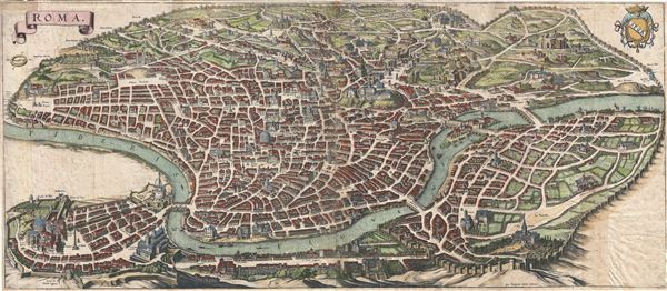
Matthäus Merian (September 22, 1593 - June 19, 1650), sometimes referred to as 'the Elder' to distinguish from his son, was an important Swiss engraver and cartographer active in the early to mid 17th century. Merian was born in Basel and studied engraving in the centers of Zurich, Strasbourg, Nancy and Paris. In time Merian was drawn to the publishing mecca of Frankfurt, where he met Johann Theodor de Bry, son of the famed publisher Theodor de Bry (1528 - 1598) . Merian and De Bry produced a number of important joint works and, in 1617, Merian married De Bry's daughter Maria Magdalena. In 1623 De Bry died and Merian inherited the family firm. Merian continued to publish under the De Bry's name until 1626. Around this time, Merian became a citizen of Frankfurt as such could legally work as an independent publisher. The De Bry name is therefore dropped from all of Merian's subsequent work. Of this corpus, which is substantial, Merian is best known for his finely engraved and highly detailed town plans and city views. Merian is considered one of the grand masters of the city view and a pioneer of the axonometric projection. Merian died in 1650 following several years of illness. He was succeeded in the publishing business by his two sons, Matthäus (1621 - 1687) and Caspar (1627 - 1686), who published his great works, the Topographia and Theatrum Europeaum, under the designation Merian Erben (Merian Heirs). Merian's daughter, Anna Maria Sibylla Merian, became an important naturalist and illustrator. Today the German Travel Magazine Merian is named after the famous engraver. More by this mapmaker...

Source


Merian, M., Topographia Germaniae, 1642.    

Condition


Good condition. Slightly discolorations along original folds. Older verso repairs. Some spotting. Narrow margins all around, as issued. Even overall toning.

References


Fauser, A., Repertorium alterer Topographie, (2 vols), 11928. Benevolo, L., The Architecture of the Rennaissance, vol. 2, pg. 1066.