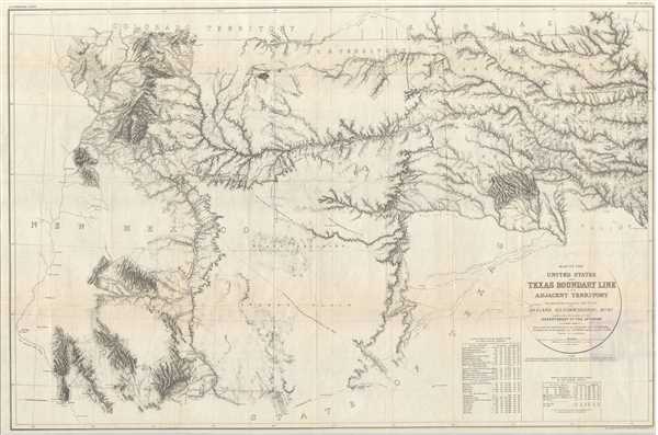
This is a scarce map issued by the United States General Printing Office detailing of the northwest boundary of Texas. This map, published in 1902, is based upon the original 1858 -1860 surveys, and was not published at the time due to the outbreak of the Civil War. It was later lost and, four decades later, rediscovered in the U.S. General Land Office. It features the survey lines between Texas and New Mexico and includes parts of New Mexico, Colorado, Kansas and Texas. It covers from Fort Wasita west to Albuquerque and notes forts, explorer’s routes, Indian trails, Spanish encampments, rivers and a host of additional topographical features. Native American settlements of the Seminole, Chickasaw and Cherokee Indians are located. Raton Pass and the Santa Fe and Albuquerque trails are also identified.
The survey was executed in 1857-1860 by J.H. Clark U.S. Commissioner under the direction of the Dept. of the Interior. Astronomical determinations were made by J.H. Clark and H. Campbell. Triangulation and Topography by J.E. Weyss, assisted by W.P. Clark. Drawn by J.E. Weyss. The Clark survey was executed in 1859-60, ten years after Texas sold its northern and western lands to the United States.
This map was part of the Geological Survey Bulletin by Marcus Baker, The Northwest boundary of Texas by Marcus Baker, U. S. Geological Survey Bulletin 194, Plate I Indexed from departmental edition (EIN137 B936 no. 194-203). The map was engraved by The Norris Peters Co., Washington D.C.
Source
Baker, M., The Northwest boundary of Texas by Marcus Baker, U. S. Geological Survey Bulletin 194, Plate I Indexed from departmental edition (EIN137 B936 no. 194-203).
Very good. Minor wear and creasing along original fold lines. Professionally flattened and backed with archival tissue.