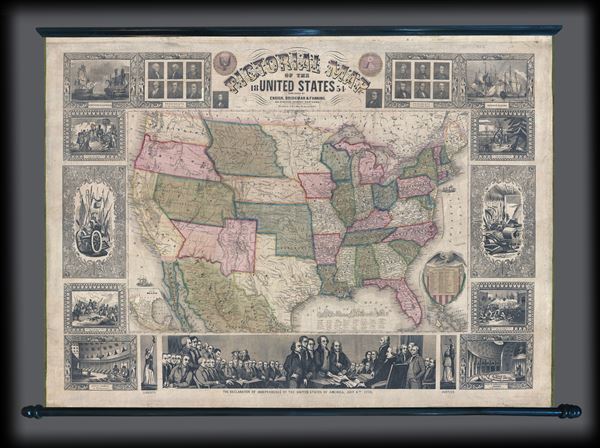
An appealing and highly decorative 1854 wall map of the United States. Issued by Ensign, Bridgman and Fanning, this map was drawn and engraved by J.M. Atwood and covers the entire United States from Atlantic to Pacific and from Canada to the Gulf of Mexico. Cartographically Atwood's map illustrates an ephemeral period in the development of the American West with each of its six known editions exhibiting significant changes and updates. The present example, representing the fifth edition, reveals major developments in the American west following the events of the 1849 Gold Rush. The Gold Region itself is highlighted with Sacramento and Sutter's City noted. Great Salt Lake is presented in an embryonic form and indicative of the generally poor knowledge of the Great Basin predating the Railroad Surveys being conducted as this map went to press. Salt Lake City itself is identified as 'Utah City of the Great Salt Lake.' The rail lines at this time extended westward no further than the Mississippi River, after which only wagon trails extended to the Pacific. Many of these are noted including the 'Route to Oregon' (the famous Oregon Trail), the 'Route to Santa Fe,' and the southern route from 'Fort Smith to Santa Fe.' Other routes presented are the tracks of Fremont and the 'Great Spanish Trail from Los Angeles to Santa Fe.' Texas shows some development including an embryonic rail system running between Austin and the port of Galveston. Nebraska extends northwards to the Canadian border and both Washington and Oregon have their eastern terminus at the Rocky Mountains. The apocryphal Louis Fork or southern extension of the Columbia River, named after Meriwether Lewis, is shown in southeastern Oregon. American Indian nations are identified throughout. A smaller map of Mexico appears on the lower left quadrant.
True its descriptive title the map is surrounded by numerous pictorial vignettes illustrating, from the title clockwise: the Presidents of the United States, Perry's Opening of Japan, the Landing of the Pilgrims in 1620, farm tools, the 1846 Battle of Monterrey (Mexican American War), the United States House of Representatives Chamber, an illustration of Justice personified, the signing of the Declaration of Independence (largest illustration, bottom center), a personification of Liberty, the Senate Chamber, the capture of General La Vega 1846 (Mexican American War), weapons and armor, the landing of Columbus 1492, the Constitution and Guerriere (Navy Ships), and again, the Presidents.
This map was first issued by Ensign and Thayer in 1847. It was republished by Ensign and Thayer in 1849 (Rumsey 5057), 1850, and 1852 (Rumsey 3508), by Thayer alone in 1853, and then in its present form by Ensign, Bridgman and Fanning in 1854, and again 1855 (Rumsey 265). A final edition by Ensign, Bridgman and Fanning appeared in 1858.
Cartographer
Edward Hooker Ensign (August 18, 1818 - July 10, 1871) was an American map and print publisher based in New York during the middle part of the 19th century. Edward was born in West Hartland, Connecticut. Little is known of Ensign's training but he may have inherited his business from his father, Timothy Ensign (1795 - 1859), who was a map publisher active in New York. Ensign seems to have had a flair for partnerships and variously published with Humphrey Phelps (1799 - 1875), Horace Thayer, Thomas C. Fanning (1805 - 1873) and Erastus C. Bridgman (1817 - 1870), among others. His various imprints include 'Phelps and Ensign' (1841-1844), 'T. and E. H. Ensign' (1844-1848), 'Ensign and Thayer' (1849), 'Ensign, Thayer, and Company' (1850-1851), 'Horace Thayer and Company' (1852), and 'Ensign, Bridgman and Fanning' (1854-1863). It appears that father and son worked together for some time as well, publishing as either 'T. and E. H. Ensign' or 'Ensigns'. At least some of these companies maintained offices in both Buffalo and New York City. More by this mapmaker...
Good. Full professional restoration and stabilization. Overall toning and crackling. Accompanied by, but unattached to, original rollers. Could be reattached on request.
Rumsey 5057.000 (1849), 5380.000 (1847). Manasek, F.J., Collecting Old Maps, p.49.