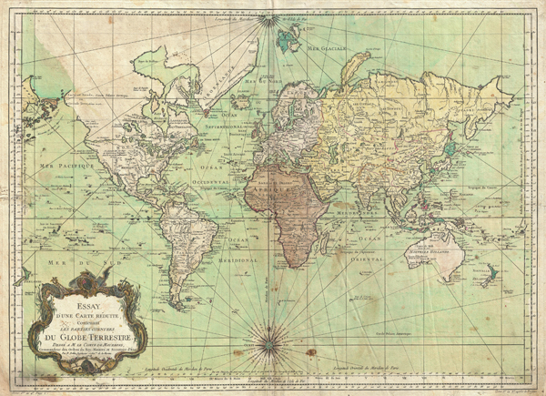
An attractive example of J. N. Bellin's 1778 nautical chart of the world. Presents the entire world on a Mercator Projection based on a Paris (L'Isle de Fer) meridian. While the map was initially composed and engraved in 1748, here it has been updated to incorporate the discoveries of Cook, Bering and Chirikov. but most specifically in the Pacific and along the northwest coast of America.
North America to the west of the Mississippi is vaguely rendered according to 16th century expeditions into the region by Coronado, La Salle, De Soto, and others. Bellin identifies the semi-mythical civilizations of Quivira and Teguayo, both associated with legends of the Seven Cities of Gold, in what is modern day Utah, California, and Nevada. Along the western coast the strait discovered by Martin Aguilar is noted. Further north still the River of the West (Fl. de l'Ouest) extends from the west coast to the Lake of the Woods (Lac de Bois) and thence via additional waterways to the Great Lakes and the Atlantic. The River of the West appeared in many 18th century maps of the Americas and is reflective of French hopes for a water route from their colonies in Canada and Louisiana to the Pacific. Still further north the coastline becomes extremely vague, in places vanishing altogether. The Aleutians are vaguely rendered according to various sightings by Vitus Jonassen Bering and Aleksei Chirikov in the 1740s and identified as the 'Archipel de Nord.'
In the Pacific, various Polynesian Island groups are noted though many are slightly or significantly misplaced. The Solomon Islands are vastly oversized referencing the early 17th claims of Quiros. The other lands discovered and erroneously mapped by Quiros in 1606 and Davis in 1686 during their search of the great southern continent are also noted. Hawaii, as yet undiscovered, is absent. New Zealand is rendered twice though is accurate in its form and position. Australia, here labeled 'Nouvelle Holland,' has part of its southern coastline ghosted in and Van Diemen's Land (Tasmania) is attached to the mainland. The southern coast of New Guinea is similarly ghosted in, suggesting its unexplored state.
The first iteration of Bellin's map was engraved by Bourgoin the younger for inclusion the 1748 first edition of the sixth volume of Prevost's Histoire générale des voyages, and it is so dated. A second plate, with the same date but entirely re-engraved, appears to have been included for later editions of the Histoire; it does not carry Bourgoin's imprint, instead displaying pagination information in the margin. It, too, is dated 1748. The present map is a later revision of this second plate. Examples of it exist with the Cook and Chirikov revisions, but with the date still unchanged. This was probably the case with this example which has had the second '7' in the 1778 date added in manuscript.
Cartographer
Jacques-Nicolas Bellin (1703 - March 21, 1772) was one of the most important cartographers of the 18th century. With a career spanning some 50 years, Bellin is best understood as geographe de cabinet and transitional mapmaker spanning the gap between 18th and early-19th century cartographic styles. His long career as Hydrographer and Ingénieur Hydrographe at the French Dépôt des cartes et plans de la Marine resulted in hundreds of high quality nautical charts of practically everywhere in the world. A true child of the Enlightenment Era, Bellin's work focuses on function and accuracy tending in the process to be less decorative than the earlier 17th and 18th century cartographic work. Unlike many of his contemporaries, Bellin was always careful to cite his references and his scholarly corpus consists of over 1400 articles on geography prepared for Diderot's Encyclopedie. Bellin, despite his extraordinary success, may not have enjoyed his work, which is described as "long, unpleasant, and hard." In addition to numerous maps and charts published during his lifetime, many of Bellin's maps were updated (or not) and published posthumously. He was succeeded as Ingénieur Hydrographe by his student, also a prolific and influential cartographer, Rigobert Bonne. More by this mapmaker...
Good. Minor soiling to margins. Light spotting here and there. Original centerfold exhibits some wear. Blank on verso.
National Library of Australia, MAP RM 75. NUC pre 1956, V. 470, p. 588.