This copy is copyright protected.
Copyright © 2024 Geographicus Rare Antique Maps
1890 W. H. Whitney / O. P. Anderson Map of Seattle
Seattle-whitney-1890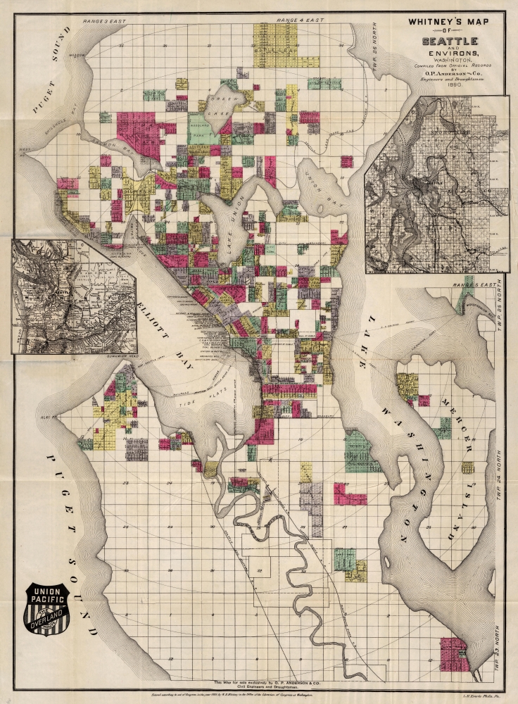

William Henry Whitney (January 3, 1843 - May 4, 1909) was an American civil engineer active in Boston in the second half of the 19th century. Whitney was born in Needham, Massachusetts. He studied at Cambridge High School then at the Lawrence Scientific School of Harvard University. In July of 1862, he enlisted in the Union Army to fight in the American Civil War (1861 - 1865). He served honorably throughout the war, seeing action and suffering wounds twice. He left the service with the rank of Brevet-Major. He served as Alderman of Cambridge. and was involved with the Back Bay development project - producing multiple maps and plans. He began his studies as a civil engineer before the war in the office of Stephen P. Fuller. From 1869 - 1871 he worked in the Boston City Engineer's Office and was involved with the Back Bay development project - producing multiple maps and plans. In 1872, he entered into partnership with J. Franklin Fuller, son of S. P. Fuller. After a short time, Fuller retired and Whitney took full control of the firm, in 1888 renaming it William H. Whitney. As a private contractor he continued to work on the Back Bay. Also around this time, he completed multiple plans for the official records of the Civil War. Between 1889 and 1890, he took a contract with the Union Pacific to produce a series of maps of western cities, including Portland, Salt Lake City, Seattle, Astoria, Port Townsend, Spokane, and more. While he did not consider them an important part of his corpus, they are today arguably his most significant works, being among the earliest obtainable plans of those cities. He was also influential in introducing blueprint technology to American architecture and engineering. More by this mapmaker...
Oliver Phelps Anderson (August 1859 – April 15, 1941) was a Seattle based photographer, draughtsman, businessman, and cartographer active from the latter part of the 19th century into the early 20th century. Anderson was born in Lexington, Illinois, the son of Alexander J. Anderson (1833 - 1903), a college professor. From 1882, Anderson was married to novelist Ada Woodruff Anderson (1860 - 1956) of San Francisco on June 4 of 1882. By the late 1880s Anderson had started his own business as a draughtsman. He opened a civil engineering and map publishing business, O. P. Anderson and Company around 1890. In this capacity he published several maps with W. H. Whitney (a somewhat mysterious figure) for the Northern Pacific Railroad. In addition to his work as a draughtsman and mapmaker, Anderson was a lifelong hobbyist photographer. As a hobbyist photographer and professional draughtsman Anderson was experienced with early cyanotype processes and quickly realized their potential for cartography. He released many of his maps in blueprint to facilitate rapid annotation and corrections before sending them to out for printing. Anderson's use of cyanotype photography to produce prototypes of his maps is, as far as we know, unique. Most of his map focus on the Seattle area, and King County, but some few also detail Alaska and the Yukon Gold Fields. Embracing his hobby, he opened a photography supply house, the Anderson Supply Company, located at 111 Cherry Street, Seattle, around 1900. Around 1913, Anderson’s son Maurice P. Anderson took over as president of the company, and Anderson acted as secretary-manager, a position he continued to hold until around 1940, probably until his death. Anderson Supply Co. continued to do business, with Maurice Anderson as president, until the late 1950s. Anderson's surviving hobbyist photographs are an important records of Seattle's development correspondent during its most meteoric period of growth in the late 19th century. Today many of Anderson's photographs are archived at the Sophie Frye Bass Library. Learn More...
Louis Humphrey Everts (April 14, 1836 - January 26, 1924) was an American map and atlas publisher active in the late 18th and early 19th century. Self-described as a "very busy and successful man", Everts was born in East Otto, New York. His family relocated to Geneva Illinois in 1851 where he worked as a clerk. In 1860 he moved to Chicago where he worked in Potter Palmer's dry-goods establishment. Following the outbreak of the America Civil War Everts joined the Union Army accepting a commission as Second Lieutenant in Company D. In 1861 he was promoted to First Lieutenant. During the course of the Civil War Everts saw action at Shiloh and Corinth before becoming an aide-de-camp to General Pleasant Adams Hackleman. He was later promoted again to the rank of Captain serving in the Western Theater and participating in Sherman's March. He ended his military service in 1865 with the rank of Brevet Major. During the war Everts befriend trade cartographer Thomas Hinckley Thompson, also a captain. Planning military strategy revealed the notable dearth of high quality county plans. Seeing a business opportunity the two teamed up as 'Everts and Thompson' (1865 - 1872) and began publishing county maps in Chicago. After the Great Chicago Fire, Everts acquired Thompson's stock and, in his own words "made the business large and profitable until it was necessary for me to visit Philadelphia and establish an office". Everts expanded his production rapidly moving away from standalone maps and refocusing on town histories and county atlases. He worked with numerous partners and seems to have been profitable, investing widely and diversely from land speculation to insurance firms. Apparently he was not the most successful investor and was forced to declare bankruptcy in 1900. Within two years he was back at head of a new firm, the Century Map Company. Active from 1902 to 1912 the Century Map Company published twelve atlases. Everts retired in 1913 and after briefly residing in a home for retired veterans moved to 215 Green Street, Philadelphia, where he lived until his death at 87 years. Learn More...
Copyright © 2024 Geographicus Rare Antique Maps | Geographicus Rare Antique Maps
This copy is copyright protected.
Copyright © 2024 Geographicus Rare Antique Maps