Title
Plan of the Foreign Concessions. Tientsin. Drawn for Crow's 'Handbook for China.'
1921 (undated)
6.5 x 12.5 in (16.51 x 31.75 cm)
1 : 27000
Description
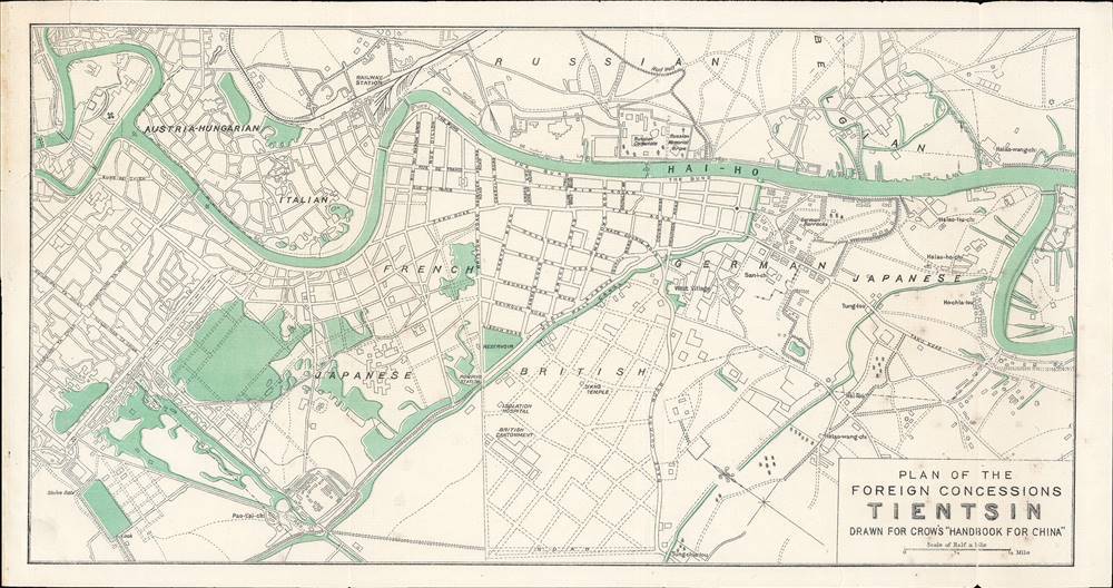
This is a c. 1913 Carl Crow city map or plan of the foreign concessions in Tianjin (Tientsin), China. The map, which is bisected by the Hai River, depicts the international concession zone, from the Austria-Hungarian concession at left to the Japanese and Belgian concessions at right.
A Closer Look
The map is oriented towards the east, with north at left and south at right. Some of the streets are labeled, mostly in the British Concession, as well the German barracks, the Russian consulate, and the railway station, etc. The Austro-Hungarian, Japanese, French, Italian, Russian, German, British, and Belgian concessions are indicated. The concessions cover 5 miles and are all located along the river.Tianjin as Gateway to Beijing and Northern China
Tianjin's location at the intersection of the Grand Canal and the Hai, often known as the Peiho River in Western sources, connecting Beijing and the Bohai Bay, made it one of the most important ports in China. Grain shipments from southern China had to travel up the canal and through Tianjin to reach the capital (Dadu or Khanbaliq under the Mongol Yuan Dynasty and Beijing under their successors, the Ming). Here, the historic walled city sits to the left (north) of the Japanese concession.
Before the 19th century, the Chinese restricted European trade because of fears that such activity would upset order in the empire. After the Second Opium War (1856 - 1860), with the Treaty of Tianjin (1858) and Convention of Beijing (1860), the ruling Qing dynasty was forced to open Tianjin as a treaty port, as had already happened to several ports further south. The first concessions in Tianjin were granted to the British and the French and the others followed between 1895 and 1900. Tianjin was the site of fighting during the Boxer Uprising in the summer of 1900, when the rebels briefly seized most of the city and cut off its connections with Beijing before being driven out by a multinational force known as the Eight Nation Alliance.
Some of the countries with concessions in Tianjin (Austria-Hungary, Italy, Belgium) did not have concessions elsewhere in China, a relic of Austria-Hungary's (rather paltry) contribution to the Eight Nation Alliance and the indemnities granted to Belgium and Italy for violence against Catholic missionaries following the Boxer Uprising. As occurred in other treaty ports, competition between Western nations was acted out on the local scene, often at the expense of China's beleaguered government. For instance, in the early 1910s, upset by an earlier expansion of the British Concession, the French Consulate and French Catholic missionaries conspired to enlarge the French Concession to Laoxikai, bordering the bottom-left portion of the British Concession here, near the Isolation Hospital and cantonment. The naked land grab was opposed by nearly everyone, including Chinese Catholics and the Holy See, and numerous rallies and a press campaign against the expansion drew considerable attention, but the presence of French police and military forces rendered it a fait accompli.
In the late Qing and Republican periods, foreign trade and investment led to Tianjin growing rapidly into one of China's most advanced and wealthiest cities. Chinese reformers of the Self-Strengthening Movement had put hopes in several projects at Tianjin in the late 19th century, including a military academy and a Western-style university (Peiyang University). Following the suppression of the Boxers, new projects could be launched more easily, notably Yuan Shikai's (1859 - 1916) plan for a new urban district in Tianjin to the north of the walled city (just outside the scope of this map). Yuan controlled the most modern and competent army in China, stationed nearby in Shandong, and built a grand European-style mansion in the Austro-Hungarian Concession in the early 20th century. Other leading Chinese political and intellectual figures also called the city home, including Liang Qichao, Puyi (the last Qing Emperor), and Ying Lianzhi, while notable foreign residents included Paul Claudel (French Consul before becoming a famous poet and playwright), the Jesuit archaeologist Emile Licent, and Herbert Hoover (who survived the Boxer Uprising while working in the mining industry).
Due to Tianjin's special status as a Treaty Port, it avoided much of the violence associated with the Chinese Civil War (1927 - 1949) and various 'incidents' with Japan. The tenuous immunity began to fall apart on July 30, 1938, when Tianjin fell to Japan during Second Sino-Japanese War (1937 - 1945). Even then, the Japanese largely respected the concessions, who were not initially occupied. Finally, in 1941, in tandem with the attack on Pearly Harbor, Imperial Japan occupied the American and British Concessions. The concessions were abolished during the war in an attempt to boost the legitimacy of the Chinese collaborationist government, and wartime or early postwar treaties between Chiang Kai-Shek's government (in Chongqing during the war) also relinquished claims on the concessions.Publication History and Census
This map was included in Carl Crow's Handbook for China, published in multiple editions between 1913 and 1933. Given the presence of Austria-Hungary and the lack of the Laoxikai extension of the French Concession, it is likely an early edition, if not 1913 then 1915 or 1916. In its various editions, Crow's handbooks are often held by research universities in North America, Europe, and East Asia. As this map was not in the text itself but appended, its prevalence relative to the handbooks themselves is difficult to determine.
Cartographer
Carl Crow (1884 - 1945) was a born in Missouri and is known for, among several achievements, opening the first Western advertising agency in Shanghai, China. Crow arrived in Shanghai in 1911, where he lived for 25 years. He worked as a journalist, newspaper proprietor, and advertising agent, while also spending time as a hostage negotiator, police sergeant, farmer, and a liaison for the U.S. government. He was also a celebrated author whose book, 400 Million Customers, won several awards when it came out in the 1930s and has been reprinted at least twice during the 21st century. During his time in China he met and interviewed most of the major figures of the day, including Chiang Kai-shek and Mao Zedong's second-in-command Zhou En-lai. Fearing retribution because of his anti-Japanese sentiments, he left Shanghai in 1937, only a couple of days after the Japanese attacked during the Second Sino-Japanese War. He worked for American intelligence during the Second World War and became one of the first westerners to journey up the Burma Road. He died in Manhattan in 1945.
More by this mapmaker...
Condition
Very good. Wear along original fold lines. Light toning. Blank on verso.
References
OCLC 911964178.