Gordon-Michael Scallion's Doomsday Maps
Using cartography to push prophecy.
How Gordon-Michael Scallion used cartography and psudo-science to promote his prophetic doomsday visions.
by Kevin Brown • January 17, 2024
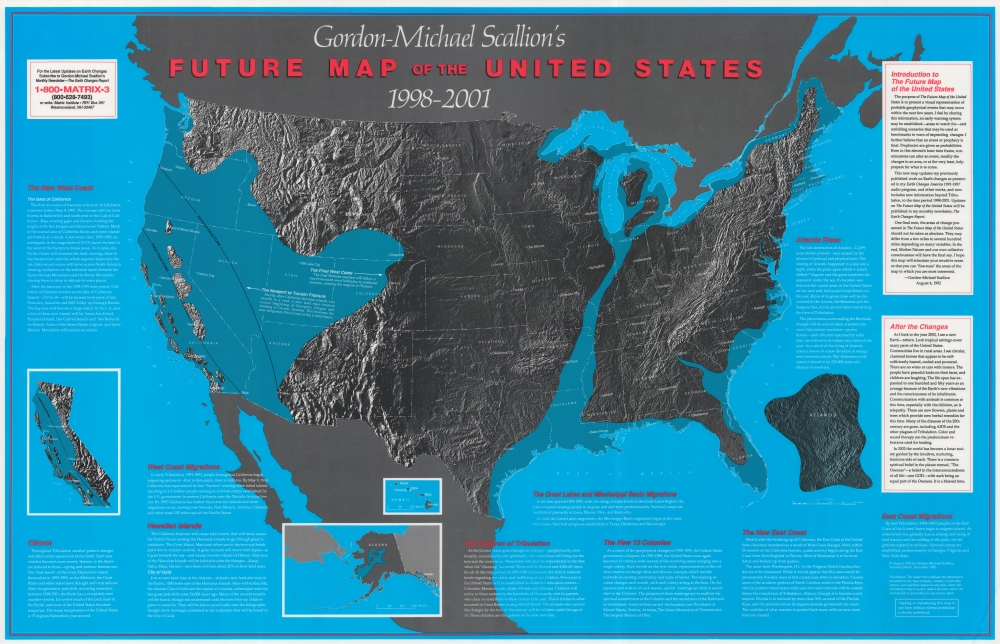
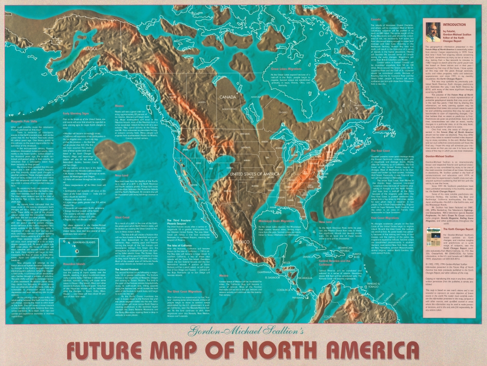
Gordon-Michael Scallion issued a series of prophetic maps between 1982 and 2002. The maps are fascinating examples of mapping alternate futures, as well as the use of cartography, actual science, and pseudo-science to promote far-fetched visions and theories. His maps and visions piece together elements including realistic predictions based on climate change, nods to the earlier 'prophet' Edgar Cayce, Biblical narrative, 15-16th century legends, U.S. and Christian-centric values, misinterpretations of several schools of science, and utter fantasy.
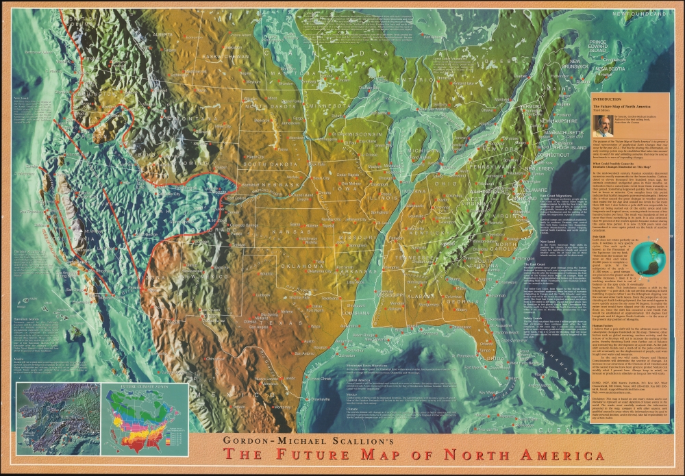
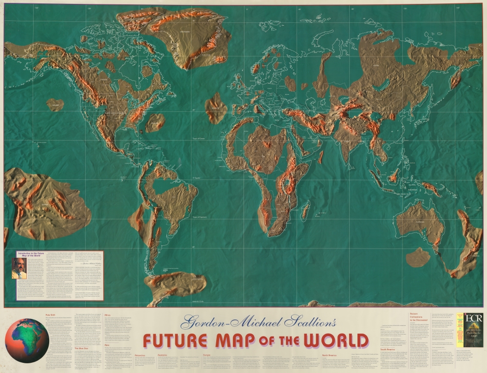
Maps of Scallion's prophetic revelations were published in multiple editions between 1982 and 2002. His corpus includes a world map (1996), several maps of the United States (1892, 1991, 1992, 1993), and at least two different maps of North America (1982, 1992, 1996). He published his first map in 1982, according to his own report, in just 100 examples which he 'put away' after showing to select friends. We have never seen this map. He had a second series of visions in 1991, leading to updates to his maps in 1991 and again in 1992.
Initially, Scallion predicted events would occur between 1998 - 2001, and most of his maps adhere to this timeline. Nonetheless, as early as 1996, Scallion began pushing his timeline as far as 2012. In 2002, his major predictions failing to materialize by 2001, he issued an updated map of North America, with this new 2012 timeline. This appears to be his last published map.
Scallion's maps have become surprisingly pervasive in several surprising contexts. Although purely fantastical, we find them used in scholarly essays about global warming, articles in prestigious magazines, throughout the blogosphere, and other similar venues - with most who use them seemingly unaware they are failed doomsday predictions. This is partly because some of Scallions 'Earth Changes,' particularly regarding water level increase in the Eastern United States and particularly Florida, today ring with truth.
U.S.-centric / Christian-centric
Scallion's prophecies range from believable to wildly outlandish. Most are notably both U.S.-centric and Christian-centric. While he does produce world maps, most of his attention focuses on North America, specifically the United States. He predicts the resurgence of the '13 Colonies' (colonies of whom?) and emphasizes the role of the United States in gestating a new 'root race' (WTF). Similarly, he embraces Christian terminology and rhetoric, for example, 'the Tribulation' and 'the Choosing' (vaguely referencing Revelation 17:14?). He dedicates little attention to the rest of the world but does note that the 'Vatican will be saved.'
Pseudo-Science
Like many modern prophets, Scallion uses scientific and pseudo-scientific terminology, combined with his interpretations of empirical data, to validate his predictions for the future and analysis of the past. His maps are no exception. They are well-made and incorporate modern mapping techniques, giving them an air of authority, which carries over to the prophetic predictions overlaying factual geographical data. Some editions of his maps incorporate scientific research Scallions seems to misunderstand, referencing 'polar shifts', plate tectonics, analysis of core samples, and more. He also describes the discovery of frozen mammoths in Siberia with grass in their mouths as evidence of instant freezing. (Instant freezing of Siberian mammoths is a pseudo-scientific claim embraced by some creationist thinkers, who use the theory in a round-about validation of the Biblical Deluge. Scientifically speaking, there is no evidence of an instant freeze. Most such frozen mammoths perished in avalanches, ice cave-ins, or other similar situations.)
The California Fracture
Perhaps Scallion's most extreme geological predictions relate to what he calls the 'California Fracture', a series of 'Mega-Super' earthquakes that will indunate California as well as the highest peaks of the Rocky Mountains well into Colorado. Scallion predicts these will be 10-15 on the Richter Scale (this is technically impossible as the magnitude of an earthquake is related to the length of the fault on which it occurs - the longer the fault, the larger the earthquake. No fault long enough to generate a magnitude 10+ earthquake exists, as it would circumnavigate the planet. The largest historical earthquake, 9.5 on the Richter scale, hit South America along the 1000-mile Andean fault). These earthquakes, he predicts, will turn Phoenix and some Nebraska cities into seaports - though it is hard to imagine any modern cities surviving such a proximal cataclysmic event.
Blue People
Scallion's predictions include more than geological changes. His most far-fetched prophecy relates to the arrival of the 'blue star' - apparently some sort of wandering star, blue in color, that arrives in our Solar System, turning it into a binary star system. This major astronomical event seems to accompany no specific disaster, but it does cause the people of Earth to turn blue and, over a generation, acquire psychic powers, which themselves are somehow related to the mythical lost continents of Lemuria and Atlantis. He seems to suggest this will include a race change, as the new blue 'Children of the Tribulation' will be the next 'root race' (whatever that is).
Conclusions
It may be tempting to dismiss Scallion's maps as fantasy, but we find them to be of the utmost interest. They are examples of how cartography can be used in the modern context to promote ideas that may or may not be true. Maps have always held an inherent air of authority, and with the advent of satellite imagery gps, Google Earth, and Google Maps, the blind belief in cartographic data has only increased. We remember Donald Trump redrawing an official weather map to reroute Hurricane Dorian in 2019, with the implication that this action might be reflected in reality - or at least change what people believe. Maps are today more powerful than ever in informing our perception of the world, and Scallion's maps are a perfect example of their use as such to promote 'one man's visions'.
All Gordon-Michal Scallion Maps for Sale on Geogrpahicus