Title
The 29th Infantry Division '29 Let's Go'.
1945 (dated)
14.5 x 44 in (36.83 x 111.76 cm)
Description
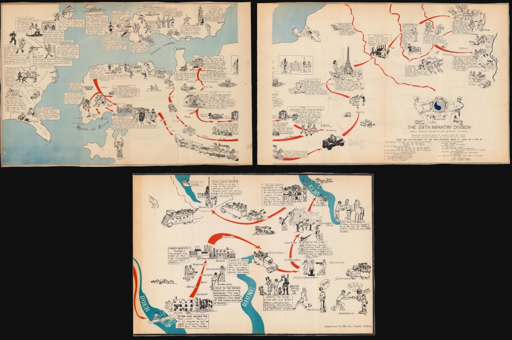
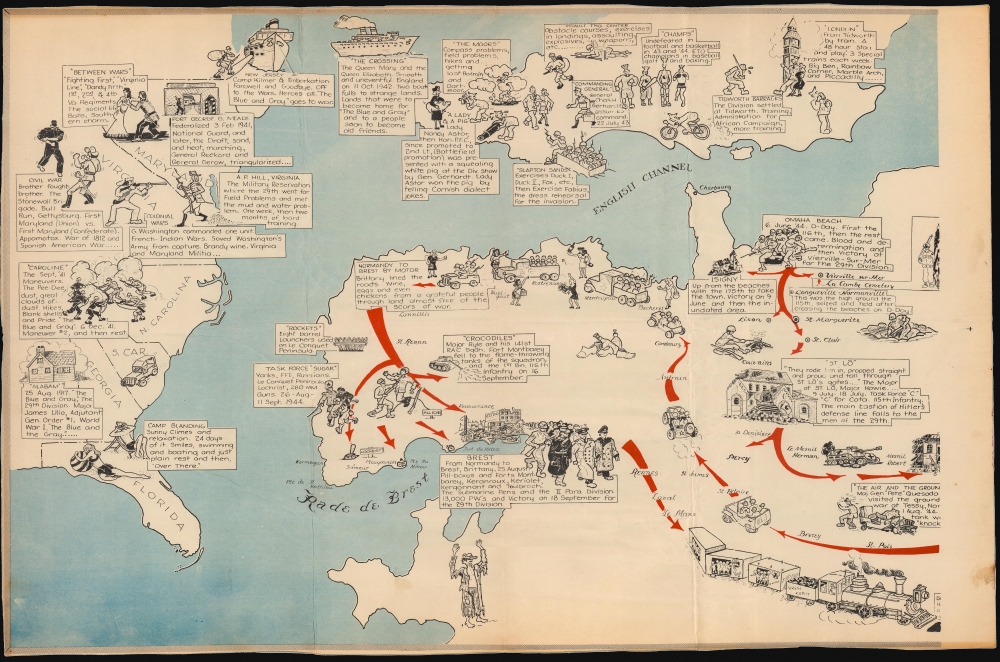
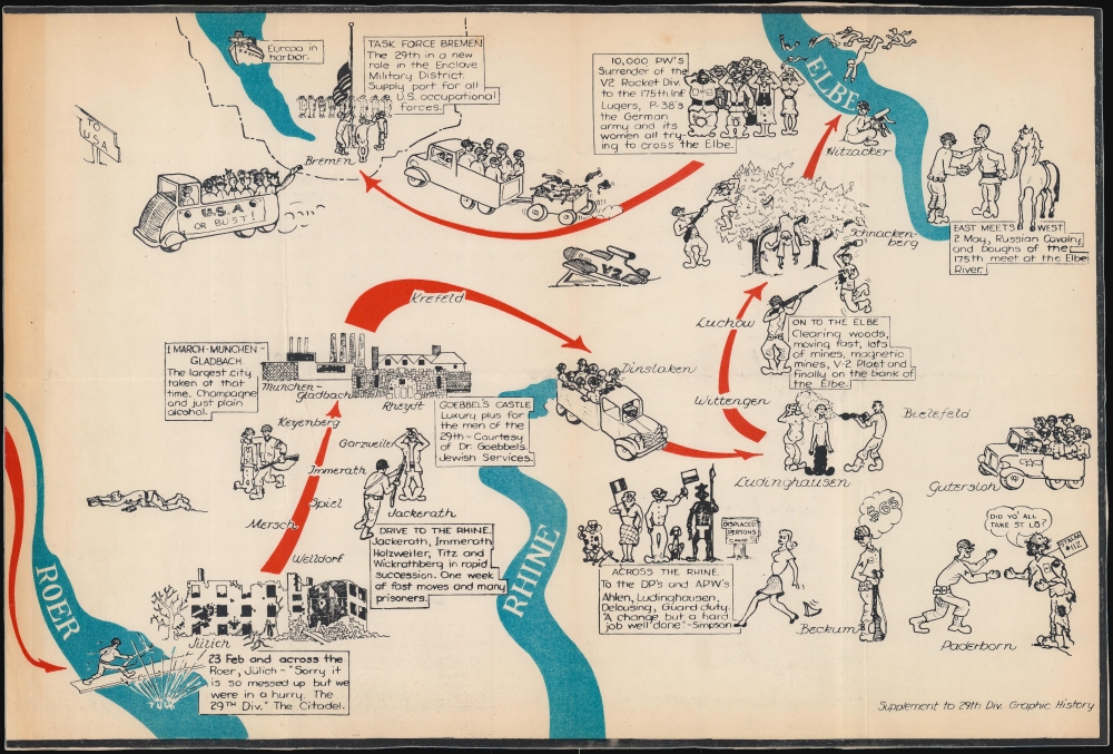
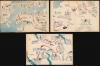
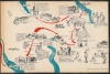
This is a 1945 29th Infantry Division World War II pictorial route map of Europe tracing the 29th's movements from the United States to England, across the English Channel to France on D-Day, and through Europe to Germany and the end of the war. Created by an unknown artist, the map provides a chronicle of the division's exploits meant for its veterans as a souvenir of all they had accomplished.
A War Story
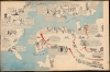
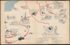
Pictorial vignettes and captions follow the 29th from being federalized on February 3, 1941, until the end of the war. Several vignettes in the United States provide a short history of the Division, including explaining its nickname ('The Blue and Gray'), a reference to the fact that the division can trace its history to the First Maryland (which fought for the Union) and the First Maryland (which fought for the Confederacy) during the American Civil War (1861 - 1865). The Division left New Jersey in October 1942 aboard the Queen Mary and the Queen Elizabeth. Vignettes in England highlight training exercises throughout 1943, as well as weekend passes to London. The Division took part in Operation Overlord, landing in Normandy on June 6, 1944, D-Day. From Normandy, it traveled south to liberate St. Lo and Vire before returning west to fight in Brittany. It liberated Brest and then sped east by train and truck, covering 650 miles in 5 days. The Division saw Paris but did not visit the city, instead bypassing it for Belgium and the Netherlands. The second sheet ends on November 27th with the Division on the banks of the Roer River. Statistics concerning the Division's accomplishments between June 6, 1944, and January 1, 1945, appear below the title. The third 'supplemental' sheet follows the Division from the February 23, 1945, crossing of the Roer River until the end of the war, and highlights the capture of Munchen-Gladbach, the crossing of the Rhine River, the capture of a V-2 factory, and meeting the Russians at the River Elbe.A Closer Look at the Vignettes and a Glimpse at the Reality of War
The vignettes on this particular piece exemplify the genre and provide an insightful commentary on the soldier experience. They begin with lounging on a beach in Florida before leaving for war. In England, the vignettes change to training exercises of crawling under barbed wire and a practice landing in a Higgins boat, while also gorging themselves on beer and romancing women in London. Once in France, the reality of war sets in. Bombed out buildings, foxholes, and wounded and dead soldiers appear. One member of the Division is shot storming the beach in Normandy. Another vignette just above a bombed-out Brest depicts an American soldier bayoneting a German. The brutality of war is, of course, 'balanced out' by illustrations of French women offering flowers, fruit, and wine to soldiers in Brittany. Two 'soldiers' drawn as salivating dogs drool over French women near the Eiffel Tower. The tone changes again once the division reaches the Roer, where one soldier steps on a land mine and another bayonets a German. The supplemental sheet features burned out buildings and surrendering Germans, along with Displaced Persons and Allied Prisoner of War camps. The subject of women and fraternization, however, appears as well. A G.I., possible standing guard duty, gets distracted by a woman in a short skirt passing by and a thought bubble reads '$65'. No matter how gallantly Americans have painted the men who fought World War II, the reality of the war was not ignored by the soldiers and was not excluded from this map or many of the others in this genre.World War II Allied Route Maps
Maps tracing unit movements during World War II were created by both American and British forces during and after the war. As a genre, these maps represent a broad range of aesthetics, from the purely functional that label places and provide dates, to the artistic, even comic. Many combine the three and provide a visually striking but historically informative summary of the unit's peregrinations. The brutal reality of the war, however, was never very far away in any of these works.Engineer Topographic Battalions during World War II
After World War II erupted in Europe, U.S. military officials realized that currently available maps of Europe were inadequate for modern artillery units or even tactical purposes. Their solution was the creation of engineer topographic battalions. Engineer Topographic Battalions provided technical support for the U.S. Army in the form of surveying, drafting, and printing maps for units on the ground. During the war, these battalions were responsible for creating accurate four-color topographic maps, along with surveying, printing, and distribution of these maps.Publication History and Census
The first two sheets of this map were created and printed by the 669th Engineer Topographic Battalion in January 1945. The third sheet was created and printed after the end of the war as a supplement to the first two sheets to illustrate the campaigns from January through May 1945. All are unattributed. We note a single cataloged example of all three sheets, at Texas A and M University.
Condition
Very good. Three sheets. Light wear and soiling along original fold lines. Closed margin tears professionally repaired on Sheet 3.
References
Texas A and M University Flat File G5721.S7 1945 .A145.