This copy is copyright protected.
Copyright © 2024 Geographicus Rare Antique Maps
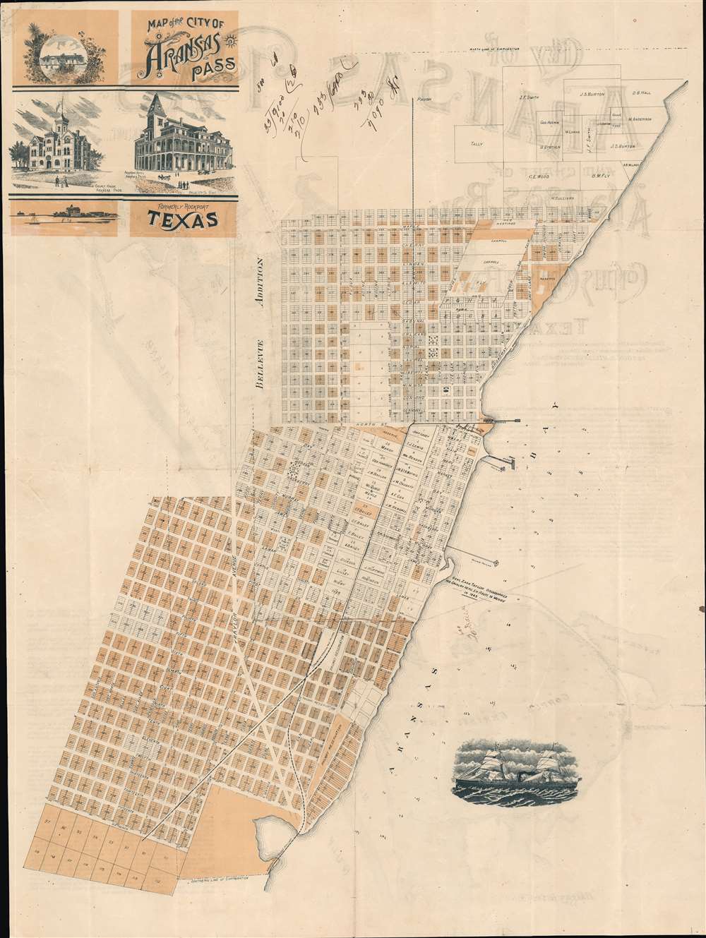
1890 San Antonio Aransas Pass Railway Map of Rockport, Corpus Christi, Texas
AransasCorpusChristiTX-millington-1905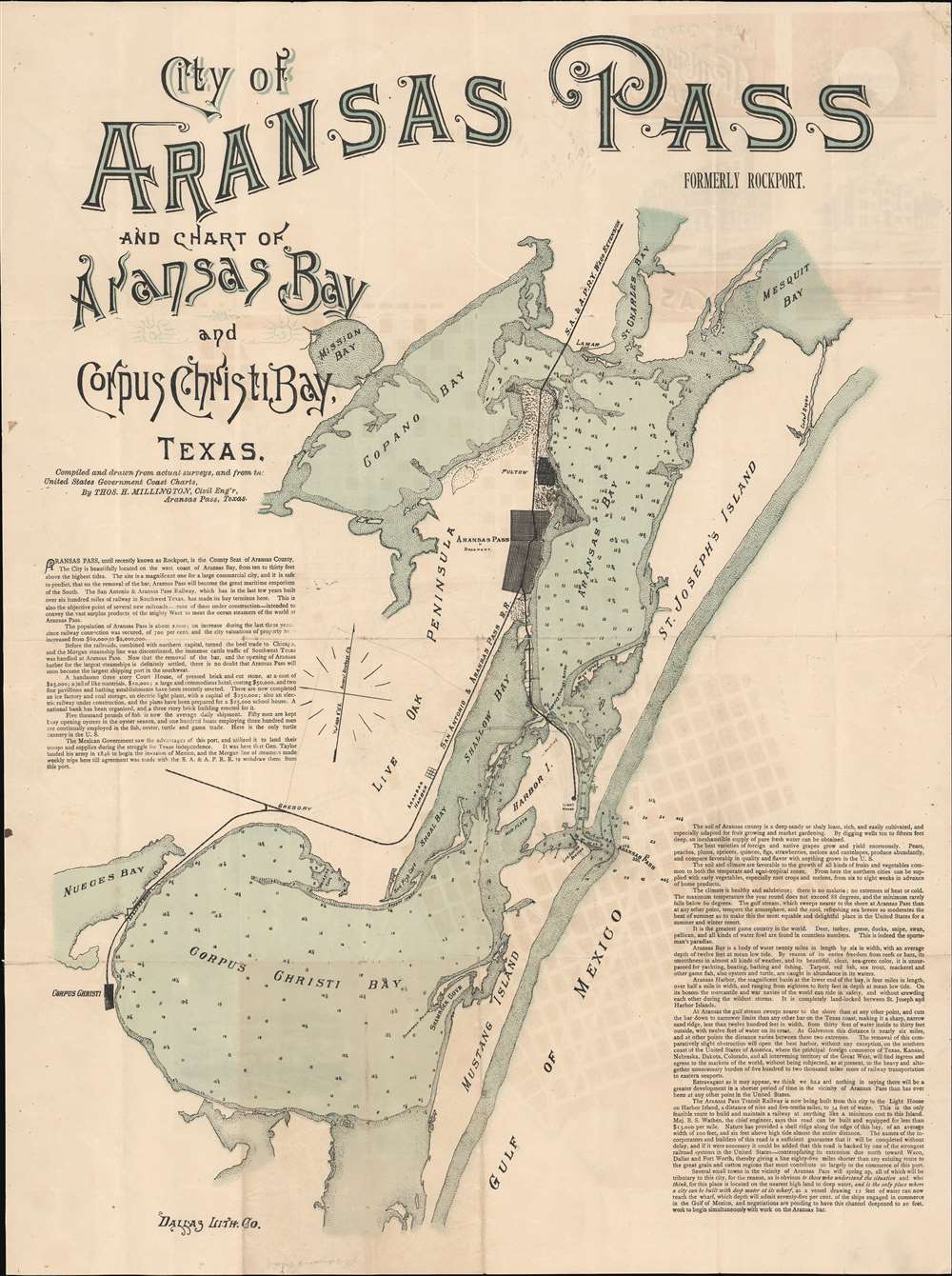

The site is a magnificent one for a large commercial city, and it is safe to predict, that on the removal of the [sand] bar, Aransas Pass will become the great maritime emporium of the South. The San Antonio and Aransas Pass Railway, which has in the last few years built over six hundred miles of railway in Southwest Texas, has made its bay terminus here. This is also the objective point of several new railroads -- some of them under construction -- intended to convey the vast surplus products of the mighty West to meet the ocean steamers of the world at Aransas Pass
South Texas is full of strange things. From South Texas came a man who built 600 miles of railroad with a five-dollar bill and faith, and the bill was a borrowed one. He moved to San Antonio from Corpus Christi with his possessions heaped on a two-wheel cart. He got a charter to build the railroad from San Antonio to Aransas Pass. He graded a mile of it, throwing a great deal more than one shovel full of dirt with his own hands. The receiver of another railroad loaned this indefatigable builder enough old rails for a mile of track. In a distant part of the State was purchased an engine which had been condemned six years before and sent to the shop to be wrecked for scrap iron. Two old cars were picked up somewhere at a bargain, and that old engine, drawing these old cars steamed into San Antonio. On this engine and cars, in bold lettering, was printed in lamp black 'S.A. and A.P.' With one mile of old rail track and with the equipment of the old engine and the two old cars, Uriah Lott started the Aransas Pass System.Lott was a dogged promoter and with additional financing from businessmen in San Antonio, construction began in earnest in 1885 and the first trains rolled out a year later in 1886. The railroad operated some 688 miles of track and provided South Texas with a new outlet to the Gulf of Mexico and international trade. By the fall of 1887 the SAAP had completed the 71-mile branch line to Kerrville. Nine months later a branch line from Corpus Christi to Rockport was completed. By early 1889 the SAAP completed the line to Houston followed immediately by a line into Waco. A horrific train wreck in 1890, high cost of track maintenance, and rapid expansion forced the SAAP into insolvency and by 1890, unable to pay its investors, it went into receivership. In 1892, it was sold to the Southern Pacific. It continued to operate under the SAAP brand but with SP management until 1925.
Thomas H. Millington (1819 - 1888) was an English-American civil and railroad engineer active in South Texas in the late 19th century. Millington was born in Prees, Shropshire, England. While it is not clear when he emigrated to the United States, he is recorded as a railroad engineer with the Nashville and Northwestern Railroad in 1856. He served the Confederate cause in the American Civil War, attaining the rank of colonel in charge of fortifications under General Pierre Gustave Toutant-Beauregard (1818 - 1893). After the war, he became chief engineer of the Memphis and Knoxville Railroad. Working with various railroad lines, Millington played a significant role in planning numerous railroad towns in the American southwest. Millington Tennessee is named after him. He was also briefly chief civil engineer for San Antonio, Texas. Four of his sons, George H Millington (1848 - 1931), Charles Alfred Millington (1850 - 1923), Joseph Millington (1852 - ????), and Frederick Alfred Millington (1853 - 1939) were also civil engineers. More by this mapmaker...
Dallas Lithograph Company (1883 - 1901) was a commercial lithography and chromolithography firm active in Dallas, Texas in the late 19th century. When founded in 1883 or 1884, it was the first lithographic press in Dallas. The founders were Isaac Monteaux, J. Booker, Nate Starke, and Thomas L Townsend (1851 - 19??). The company incorporated in 1885. They were early adaptors to the Steam Lithographic Press, capable of issuing large-scale lithographs in color and quantity. In 1890 they build an impressive three-story building at 176 Elm Street. In 1901 the firm was acquired by the Exline Printing Company. Learn More...
Copyright © 2024 Geographicus Rare Antique Maps | Geographicus Rare Antique Maps
This copy is copyright protected.
Copyright © 2024 Geographicus Rare Antique Maps