Title
Atlantis at its Prime. / Atlantis in its Decadence. / Ruta and Daitya. / Poseidonis.
1900 (undated)
14 x 18 in (35.56 x 45.72 cm)
1 : 105000000
Description
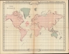
An intriguing set of 4 maps, c. 1900, tracing the rise and fall of the lost civilization of Atlantis based upon the writings of William Scott-Elliot and the clairvoyant visions of Charles Webster Leadbeater. The maps underscore the late 19th and early 20th century obsession with Atlantis and all things 'mystical', as well as the need to contextualize 'clairvoyant' visions with history and science.
A Closer Look
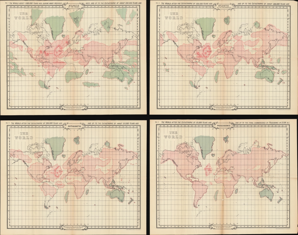
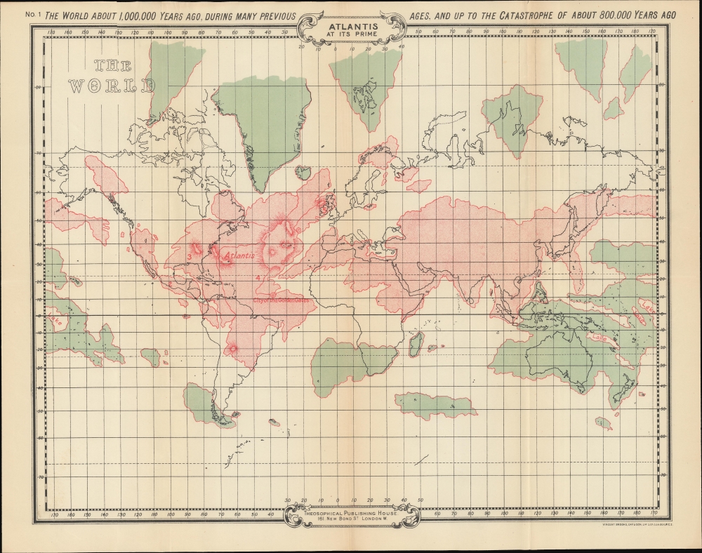
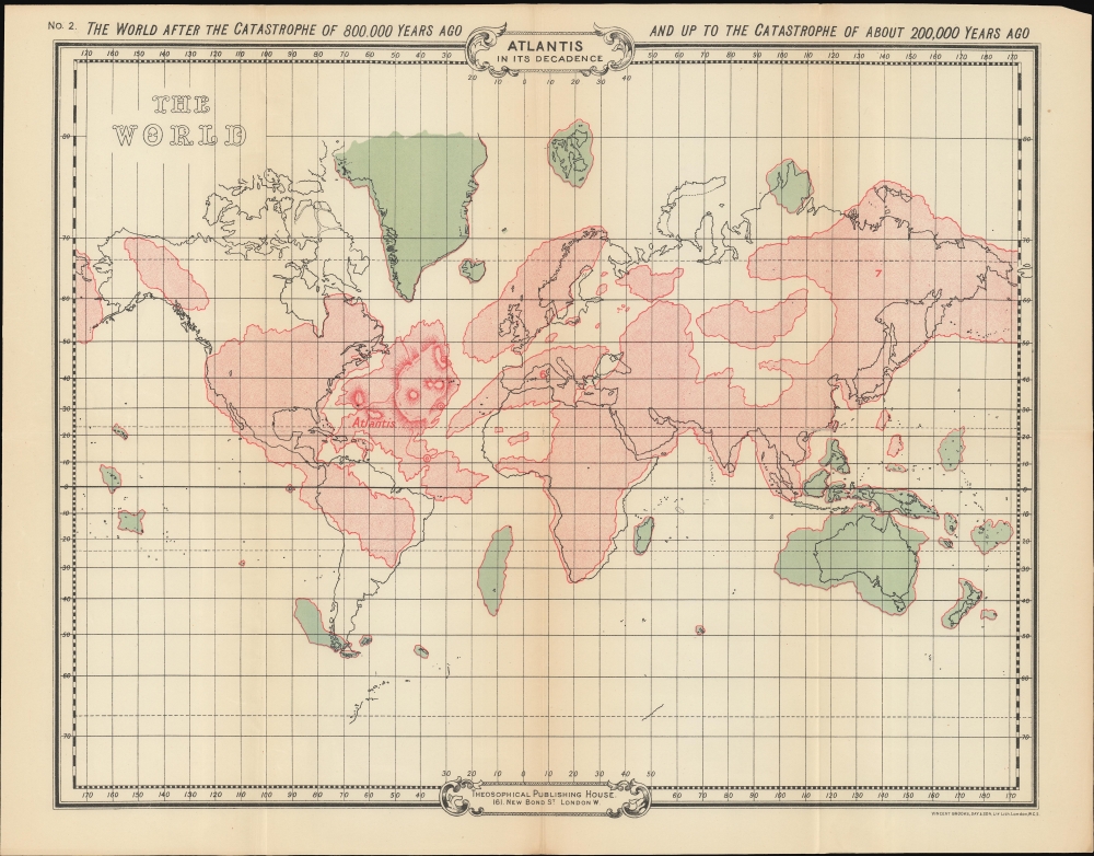
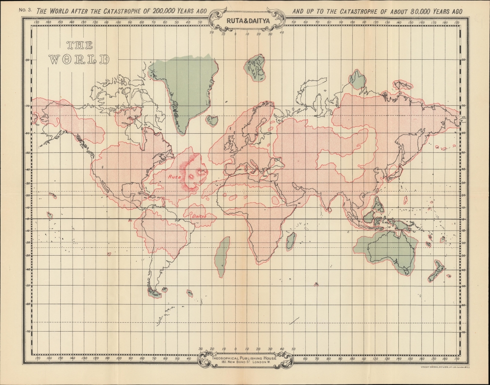
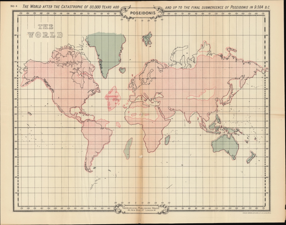
The set consists of four 'historical' world maps covering from roughly 1,000,000 years ago to 9,564 BCE. The maps feature red and blue-green continental masses superimposed over an outline Mercator projection. Red represents the reach of the Atlantean civilization, while blue indicates the remains of the proto-continent of Hyperborea (including the lost Lemuria). Some topography is included on the island of Atlantis itself.Contextualizing Esoterism
These works are based on Scott-Elliot's attempts to bring 'scientific', 'historical', and 'religious' context to the clairvoyant visions of Theosophist Charles Webster Leadbeater. Much of Scott-Elliot's work is based upon the earlier fringe writings of Ignatius Loyola Donnelly, an American politician, conman, and pseudo-scientist whose 1882 work, Atlantis: The Antediluvian World, popularized the modern conceptualization of Atlantis. We put both 'scientific' and 'historical' in quotes, as both authors were attempting to combine new scientific and archeology discoveries, existing historical suppositions, outlandish anthropological and ethnological theories, religion, and the then nascent occultist stream of Western esotericism.Atlantis
Scott-Elliot described an Atlantean civilization that reached its peak some 1,000,000 years ago, during a period with a very different continental structure. Through a serious of progressive global catastrophes, brought on by Atlantean moral bankruptcy, the continent shrunk in stages - the last vestige being named Poseidonis and corresponding with the lost civilization as described by Plato in Timaeus and Critias. Poseidonis itself receded into the Atlantic during the Biblical Deluge, which he dates to exactly 9,564 B.C.Scott-Elliot Describes His Maps
We'll let Scott-Elliot speak for the maps himself:
First Map Period:Before beginning the history of the race, however, a few remarks may be made about the geography of the four different epochs. The first map represents the land surface of the earth as it existed about a million years ago, when the Atlantean Race was at its height, and before the first great submergence took place about 800,000 years ago. The continent of Atlantis itself, it will be observed, extended from a point a few degrees east of Iceland to about the site now occupied by Rio de Janeiro, in South America. Embracing Texas and the Gulf of Mexico, the Southern and Eastern States of America, up to and including Labrador, it stretched across the ocean to our own islands -Scotland and Ireland, and a small portion of the north of England forming one of its promontories - while its equatorial lands embraced Brazil and the Atlantis at its prime, and the whole stretch of ocean to the African Gold Coast. Scattered fragments of what eventually became the continents of Europe, Africa and America, as well as remains of the still older, and once widespread continent of Lemuria, are also shown on this map. The remains of the still older Hyperborean continent which was inhabited by the Second Root Race, are also given, and like Lemuria, coloured blue.
Second Map Period: As will be seen from the second map the catastrophe of 800,000 years ago caused very great changes in the land distribution of the globe. The great continent is now shorn of its northern regions, and its remaining portion has been still further rent. The now growing American continent is separated by a chasm from its parent continent of Atlantis, and this no longer comprises any of the lands now existing, but occupies the bulk of the Atlantic basin from about 50′ north to a few degrees south of the Equator. The subsidences and upheavals in other parts of the world have also been considerable - the British Islands for example, now being part of a huge island which also embraces the Scandinavian peninsula, the North of France, and all the intervening and some of the surrounding seas. The dimensions of the remains of Lemuria it will be observed, have been further curtailed, while Europe, Africa and America have received accretions of territory.
Third Map Period: The third map shows the results of the catastrophe which took place about 200,000 years ago. With the exception of the rents in the continents both of Atlantis and America, and the submergence of Egypt, it will be seen how relatively unimportant were the subsidences and upheavals at this epoch, indeed the fact that this catastrophe has not always been considered as one of the great ones, is apparent from the quotation already given from the sacred book of the Guatemalans - three great ones only being there mentioned. The Scandinavian island however, appears now as joined to the mainland. The two islands into which Atlantis was now split were known by the names of Ruta and Daitya.
Fourth Map Period: The stupendous character of the natural convulsion that took place about 80,000 years ago, will be apparent from the fourth map. Daitya, the smaller and more southerly of the islands, has almost entirely disappeared, while of Ruta there only remains the relatively small island of Poseidonis. This map was compiled about 75,000 years ago, and it no doubt fairly represents the land surface of the earth from that period onwards till the final submergence of Poseidonis in 9564 B.C., though during that period minor changes must have taken place. It will be noted that the land outlines had then begun to assume roughly the same appearance they do to-day, though the British Islands were still joined to the European continent, while the Baltic Sea was nonexistent, and the Sahara desert then formed part of the ocean floor.Publication History and Census
These maps were drawn by Scott-Elliot and published by the Theosophical Publishing House, London. The book in which it was published, Story of Atlantis was first issued in 1896. Subsequent issues by the Theosophical Press followed until about 1925, all containing the present maps. The present example exhibits a secondary imprint of the lithography Vincent Brooks, Day and Son', suggesting a latter issue. Otherwise, it is impossible to determine which edition the maps came from as paper and printing are near identical. We have chosen a mid-road date for this set as c. 1900.
Cartographer
William Scott-Elliot (March 24, 1849 - September 2, 1919) was a Scottish nobleman, merchant banker, theosophist, and amateur historian. Scott-Elliot was born in Edinburgh and inherited the title of Laird of Arkleton. He attended the Rugby School, in Edinburgh, before going on to a career in London with the banking firm Wallace Brothers. He was an early member of the London Lodge of the Theosophical Society and is today best known for his accounts of the lost continents of Atlantis and Lemuria, based on the clairvoyant visions of Charles Webster Leadbeater (1847 - 1934). More by this mapmaker...
Source
Scott-Elliot, W., The Story of Atlantis, (London: Theosophical Publishing) c. 1900.
Condition
Good. Old fold lines. Even toning. Map 3, 'Poseidonis', exhibits slight infill along centerfold.
References
University of Wisconsin, Rare GN751 .S43 1896 LC classed maps. OCLC 991622056.