An uncommon 1897 early example of a George H. Walker aquatint view of Boston Harbor. It presents the city and harbor as teeming with activity, a testament to Boston's dynamism at the turn of the 20th century.
A Closer Look
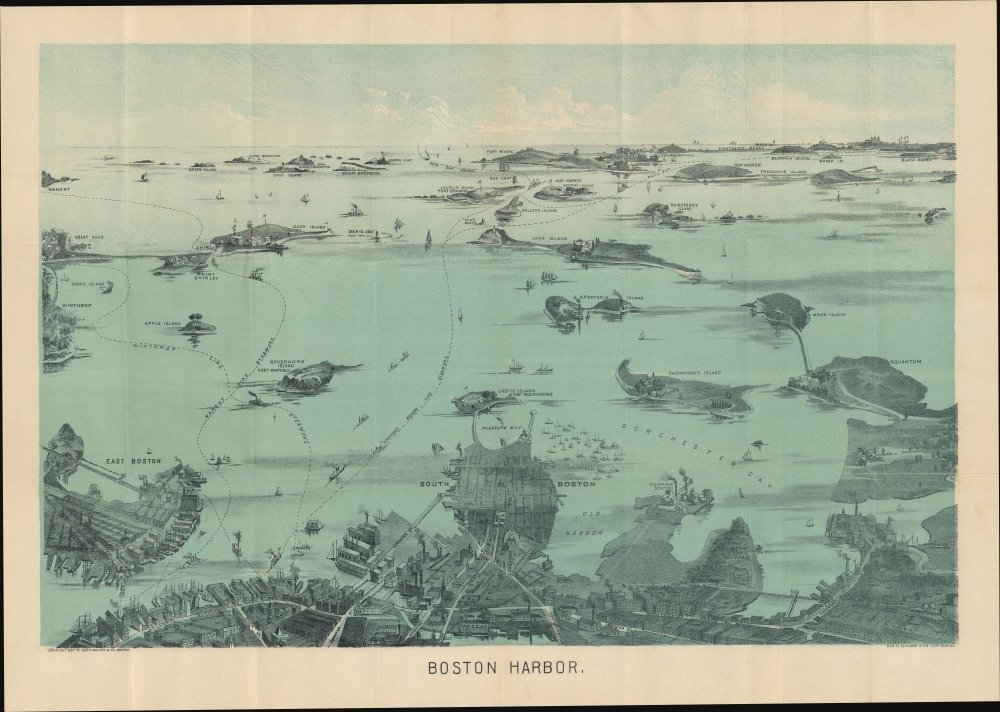
Centered on South Boston and oriented towards the southeast, the view depicts Boston Harbor from East Boston and Nahant eastward as far as Squantum and Slate Island. The bustling harbor is illustrated full of ships and ferries traveling between various islands and cities (views such as this were sold and given to customers of various Boston-based ferry services). Islands throughout the harbor are illustrated, including Thompson's Island, Castle Island, Spectacle Island, Governors Island, Deer Island, Lovell's Island, Calf Island, and Peodock's Island. Various lighthouses are illustrated and labeled, including Boston Light, Bug Light, and Minots Ledge Light.Continuity and Change
Walker published this view in several editions from 1897 and until around 1925 (see 'Publication History and Census below). Comparing this early edition to a late c. 1925 edition (previously sold by us) reveals changes in the cityscape. Though the two are superficially nearly identical, a close examination demonstrates several minor but notable changes. Most noticeably, the 1925 edition expands the scope slightly to the right (westwards) to include Hough's Neck, the Fore River Shipyard, and other points along the coastline in Quincy. East Boston is also more filled in, with land reclamation significantly expanding the area of usable land, including the addition of what would eventually become Logan International Airport. Some changes are also recognizable in Boston proper, such as the Custom House Tower, the tallest building in the city when completed in 1915. Even minute details, such as the upgrading of a bridge on Dorchester Ave. near South Station, were updated for accuracy.Publication History and Census
George H. Walker and Co. published this view in several editions (not all of which are dated) in the late 19th and early 20th century, up to around 1925. This dated 1897 edition appears to be the earliest. It is not listed in the OCLC, though the Library of Congress looks to hold a slightly modified printing of the same edition (OCLC 925600125).
Cartographer
George Hiram Walker (January 4, 1852 - November 14, 1927) was a Boston based publisher of books, views, and maps active in the late 19th and early 20th centuries. Born in Springfield, Vermont, Walker started his life as a dry goods merchant but developed an active interest in publishing during the early 1870s. Walker began publishing in 1878 when he partnered with an unknown New York Firm. Two years later, Walker brought the operation in house by partnering with his brother, Oscar W. Walker, in the opening of a lithography studio at 81 Milk Street, Boston. Shortly thereafter the firm expanded to new offices at 160 Tremont Street, Boston. The Walker brothers produced a large corpus of works, most of which focused on travel and tourism in New England. Walker also established the Walker-Gordon Milk Laboratory with Dr. Thomas Morgan Rotch and Gustave Gordon. This interesting investment was based on the premise that infant deaths could be avoided by providing higher quality milk. The company eventually became a great success, producing a high-quality cow milk that closely resembled human breast milk. In the process the Walker-Gordon laboratory developed many of the dairy health standards that are still with us today. Walker married Irene L. Loud on March 25, 1885. More by this mapmaker...
Very good. Creasing along fold lines.