1838 Norie Blueback Chart / Map of the English Channel and South England

BritishChannel-norie-1838
$1,200.00
A Chart of the British Channel, Drawn From the Ordnance and Admiralty Surveys, the Observations of Admiral Sir John Knight, K. C. B., and Other Authentic Documents. - Main View
Processing...

1838 Norie Blueback Chart / Map of the English Channel and South England

BritishChannel-norie-1838

Sailed nautical chart of the English Channel.
$1,200.00

Title


A Chart of the British Channel, Drawn From the Ordnance and Admiralty Surveys, the Observations of Admiral Sir John Knight, K. C. B., and Other Authentic Documents.
  1838 (dated)     37.5 x 73 in (95.25 x 185.42 cm)     1 : 565000

Description


This is a large 1838 John William Norie blueback nautical chart or maritime map of the English Channel. The map depicts the region from just west of Ireland to the North Sea and from England, Wales, and Ireland to northern France. This chart has all of the atmospheric hallmarks of a working nautical chart and a life at sea. Myriad depth soundings are included throughout, including along the coast of St. George's Channel and in Bristol Channel. Numerous soundings are indicated in the Thames Estuary, and the Thames is illustrated all the way to London. Locations along the English, Welsh, Irish, and French coasts are labeled, including Cork, Cardiff, Bristol, Lands' End, Southampton, and Brighton. The Isle of Wight is labeled. Inset maps along the top border include Mounts Bay, Land's End, Spithead and Portsmouth, Portland, New Haven, and the Isle of Sheppy. Along the right and bottom borders, inset maps detail Exmouth Bar, the Scilly Isles, and Dartmouth Harbor. Several coastal views are also illustrated, including Lizard, Portland, Berry Head, Start Point, Bembridge Point, Beachy Head, Looe Island, the Needle Rocks, and the Scilly Islands. Manuscript red and yellow notations note the location of lighthouses along the English coast. Several lighthouses are illustrated in profile.
Blueback Charts
Blueback nautical charts began appearing in London in the late 18th century. Bluebacks, as they came to be called, were privately published large format nautical charts known for their distinctive blue paper backing. The backing, a commonly available blue manila paper traditionally used by publishers to warp unbound pamphlets, was adopted as a practical way to reinforce the low-quality paper used by private chart publishers in an effort to cut costs. The earliest known blueback charts include a 1760 chart issued by Mount and Page, and a 1787 chart issued by Robert Sayer. The tradition took off in the early 19th century, when British publishers like John Hamilton Moore, Robert Blachford, James Imray, William Heather, John William Norie, Charles Wilson, David Steel, R. H. Laurie, and John Hobbs, among others, rose to dominate the chart trade. Bluebacks became so popular that the convention was embraced by chartmakers outside of England, including Americans Edmund March Blunt and George Eldridge, as well as Scandinavian, French, German, Russian, and Spanish chartmakers. Blueback charts remained popular until the late 19th century, when government subsidized organizations like the British Admiralty Hydrographic Office and the United States Coast Survey, began issuing their own superior charts on high quality paper that did not require reinforcement.
Publication History and Census
This map was published by John William Norie in 1838. All examples are rare. This map is owned jointly by Geographicus and Vetus Carta Maps.

Cartographer


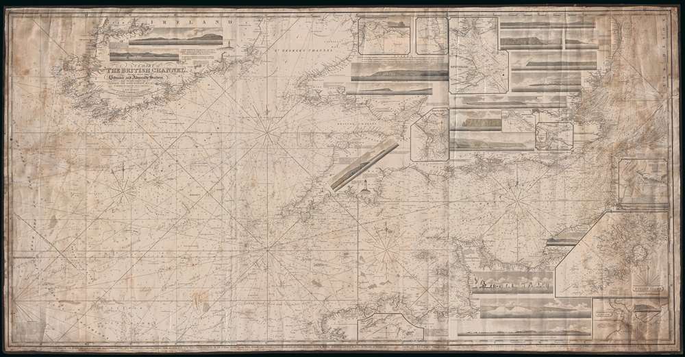
John William Norie (June 3, 1772 - December 24, 1843) was a British teacher of navigation, hydrographer, chart maker, and publisher of maritime manuals active in London, England in the late 18th and early 19th centuries. Norie was born in Wapping, London, an area long associated with the maritime sciences. Norie's career as a chart maker commenced under the tutelage of William Heather, a prominent purveyor and publisher of nautical charts, pilot books, and navigational tools who took over the firm of Mount and Page in 1765. Heather and Norie were likely acquainted through John Hamilton Moore, another important chart maker with whom both seem to have been associated early in their careers. Heather hired Norie to teach basic navigation at his shop at 157 Leadenhall Street. Under Heather Norie also distinguished himself as a draftsman, completing many of the early charts associated with the Heather firm. When Heather died in 1812 John Norie partnered with George Wilson, a moneyed 'man about town' with little experience in the maritime trades, to acquire the map and chart business at 9500 British Pounds. It proved a good deal for Norie, who retained all copyright privileges and drew 1/4 quarter share of business profits, as well an impressive quarterly salary and, for doing all of the work, 1/3rd of Wilson's share. The firm, referred to as the 'Naval Warehouse' quickly acquired a reputation for quality navigational materials and became a favorite of merchant seamen. It was even referenced in Charles Dickens' classic novel Dombey and Son. In 1819, Norie and Wilson acquired the failing chart business of David Steel, which significantly increased the size, though not quality, of their chart catalogue. With the rise of the British Admiralty and its own maritime chart productions, the business of "Chart Purveyor" in London dramatically changed. Admiralty charts and pilot books, designed for military use, were offered through established intermediaries, like Norie, at bargain prices. Most chart makers of the period found it profitable to use the highly technical Admiralty charts to update their own more decorative vernacular charts. For a brief time this practice proved exceptionally profitable but eventually began to draw criticism. Nonetheless, Norie retired to Edinburgh in 1840 and died a wealthy man in 1843. In 1840 the business passed to a nephew of George Wilson, Charles Wilson, who renamed the firm "Norie & Wilson". William Heather Norie, J. W. Norie's own son, produced few charts, instead pursuing a career in the legal field. Norie & Wilson merged with James Imray's prosperous chart business in 1899, becoming Imray, Laurie, Norie & Wilson, a profitable concern that remains active in the maritime charting industry. More by this mapmaker...

Condition


Good. Soiling. Blank on verso.