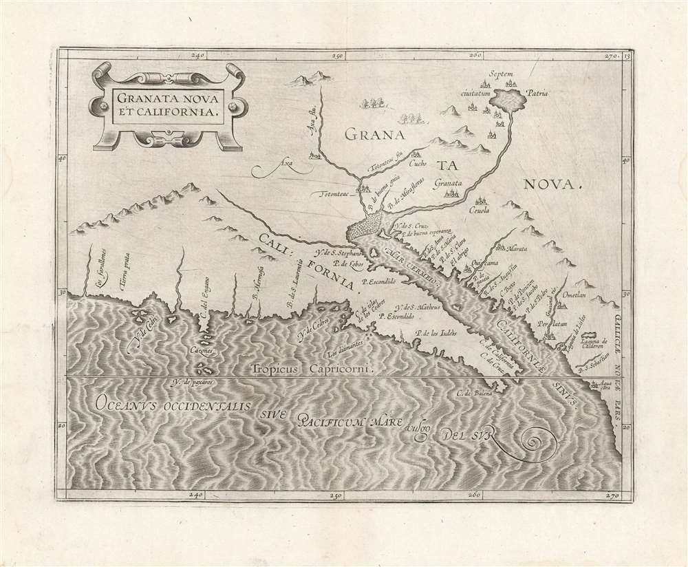
A superb example of Cornelis Wytfliet's 1597 map of California and New Granada - the first printed map specifically of California, and the only in the 16th century. It reveals the earliest Spanish glimpses of a region whose remoteness from Europe would leave it prone to dramatic cartographic error throughout the subsequent centures.
The Source of a River, the Source of the Map
It is commonly written that the geographical information for Wytfliet's maps was predominantly drawn from the more general works of Mercator and Ortelius. In the present map, this cannot be the case. The region mapped here does not resemble either of those cartographers' works. One prominent difference is that Wytfliet's map includes an imaginary inland lake at the source of a Colorado-esque river flowing into the Gulf of California. This lake manifested first in the 1587 Hakluyt map of the Americas - albeit much larger. Burden suggests that its appearance was derived from António de Espejo (1540 - 1585), who first reported such a lake in 1586, after the relevant Ortelius maps. Mercator's wall map of the world covers the relevant region with a cartouche.
The next mapping of this lake is on the 1592 Plancius Nova et Exacta Terrarum Orbis Tabula Geographica Ac Hydrographica, and while there are differences between Plancius's geography and Wytfliet's (most notably Wytfliet's unnamed river flowing from the west into the Gulf of Califoria) the similarities outweigh them. The course of the river in question is similar on both maps and they both place a lake at its source. Both maps illustrate the Seven Cities situated around the lake. Also, the overall shape of the peninsula of California, the orientation of its coastline, and the place names along that coast are very similar. Scrutiny of the 1593 De Jode map of North America, itself closely derived from the Plancius map, reveals that the similarity between it and the Wytfliet is even stronger. The course of the river from the lake is a closer match than to the Plancius. Thus, a transmission of geographical ideas from Plancius, to De Jode, to Wytfliet seems most plausible.Spanish Reports
In addition to de Espejo's lake, the fabled seven cities of Cibola are depicted here. These first surface in the largely fantasized 1539 reports of Father Marcos de Niza (c. 1495 - 1558). The map does preserve many place names (Axa, Tontontess, Granata, and Marata, for example) derived from Francisco Vázquez de Coronado's (1510 - 1554) 1539-40 expedition.Publication History and Census
This map was engraved in Louvain in 1597 Cornelis Wytfliet's Descriptionis Ptolemaicae Augmentum, a work intended to focus on the parts of the world unknown to Ptolemy. After the 1597 printing, six further editions followed. There is only one known state. The present example exhibits a bold, dark image suggestive of an early strike. The map in its various editions is well represented in institutional collections. Examples of this quality have become scarce on the market.
Cartographer
Cornelius van Wytfliet (1555 - 1597) was a Flemish cartographer and engraver active in the second half of the 16th century. Little unfortunately is known of Wytfliet's life or education. He seems to have been employed as secretary to the Council of Brabant, essentially the supreme court of the Duchy of Brabant. In cartographic circles Wytfliet is best known for his publication in 1597 of Descriptionis Ptolemaicae Augmentum, the first atlas dedicated exclusively to the America's. Wytfliet imaged the atlas as a supplement to classical Ptolemaic geographic, which traditionally accounted only for Europe, Africa, and Asia. The 19 maps contained within the Descriptionis Ptolemaicae Augmentum are some of the earliest specific maps detailed various parts of the Americas. More by this mapmaker...
Source
Wytfliet, C., Descriptionis Ptolemaicae Augmentum sive Occidentis Notitia Brevi commentario illustrata Studio et opera Cornely Wytfliet Louaniensis, (Louvain) 1597.
Fine. Generous margins, no soiling and no mends.
OCLC 18058018. Rumsey 11622.048. Burden, P., The Mapping of North America, 106; Wheat,C. Transmississippi West, I, p. 28.