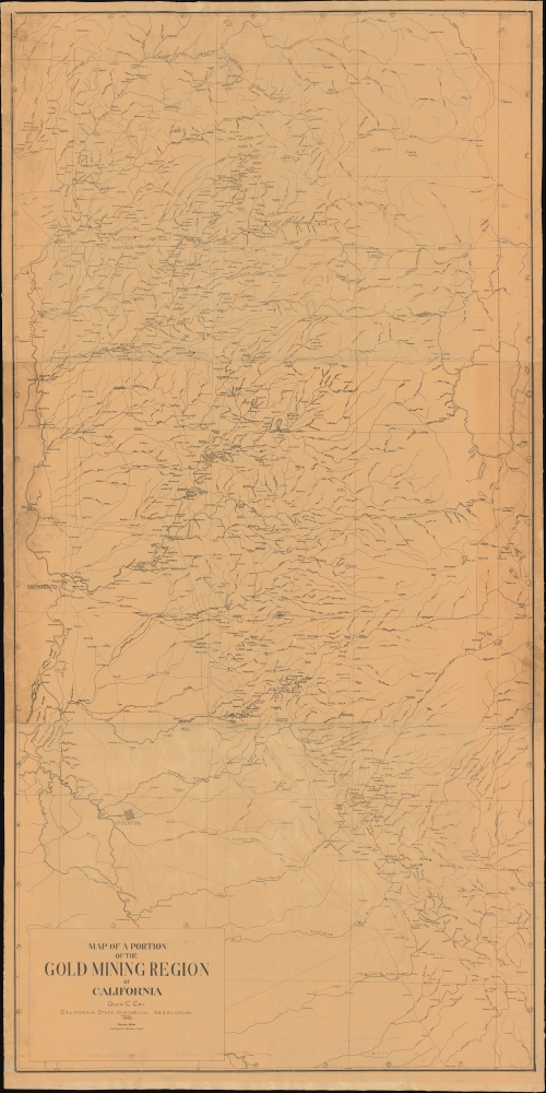
Title
Map of a Portion of the Gold Mining Region of California.
1948 (dated)
68 x 34 in (172.72 x 86.36 cm)
1 : 190080
Description
A triumph of research, this is a meticulously detailed wall map of the California gold region at the height of the Gold Rush. It was published in 1948 on the centennial of the Gold Rush by researcher Owen C. Joy and the California State Historical Association. Coverage of the 'diggings' extends from the northern portion of the Sierra Valley in Plumas County in the north to Mariposa County in the south.
A Closer Look
The exact date represented here, if any, is unclear, but likely represents the apex gold rush in the early 1850s. 'New Helvetia' has already been renamed Sacramento and a number of other settlements, such as Plumas City and Marysville, which were initially shanty towns of miners' tents are indicated as proper towns. Notably, Stockton, which became the 'supply depot' of the gold rush, is a considerably-sized and planned town. An Expert on the 'Diggings'
Coy, an expert on gold rush 'diggings', has incorporated his extensive research. Many of the sites indicated did not last long, springing up and disappearing as strikes were discovered and exhausted. Their names reflect the origins of the miners ('Italian Bar,' 'Vermont Bar,' 'Texas Diggings,' 'Kennebec Bar,' 'French Camp'), their aspirations ('Gold Springs,' 'Eldorado'), and the local environment ('Grizzly Flat,' which is circled). One site near right-center is designated 'Hellhole.'James Beckwith (or Beckwourth), Frontier Trailblazer
Paths between sites and through the mountains are not labelled but indicated with dashed lines. One of these paths, near top-right, along with the nearby town of Beckwith and Beckwith Butte, are named for James Beckwith (or Beckwourth). Beckwith was a mixed-race man who had been born into slavery in Virginia, the son of a slaveowner who later freed him. He subsequently spent years as a fur trapper on the American frontier. After being captured by the Crow, he lived among them for nearly a decade, and, by his account, rose to the status of chief. His story bears some similarity to that of York, a member of the Lewis and Clark Expedition enslaved to William Clark who may have returned to the frontier later in life. Historians debate whether a fur trader's account of a black man living among the Crow as a chief was York or, in fact, Beckwith.
When the California Gold Rush began, Beckwith set up shop in Sonoma and then Sacramento before making his name for guiding prospective miners through the Sierra Nevadas on an old Native American trail that came to be known as Beckwourth Pass, near top-right here. This route obviated the need to take much more hazardous high elevation passes, such as Donner Pass, to the south. Beckwith eventually settled down to ranch and established a hotel. There, one night, he dictated his life story to a traveler and guest, Thomas D. Bonner, who later published The Life and Adventures of James P. Beckwourth. The work proved immensely popular, although details of the story have been questioned ever since its publication.
After his time in California, Beckwith moved to Denver, became an 'Indian agent' for the U.S. government and a scout for the U.S. Cavalry and various frontier militias, including for Col. John Chivington (1821 - 1894), perpetrator of the 1864 Sand Creek Massacre. Beckwith died, perhaps by poisoning, while leading a U.S. military column through Crow Territory. He was given a traditional Crow burial in Laramie, Wyoming. Though the veracity of some details of his remarkable biography are dubious, his story is nevertheless an important reminder of the role of African Americans in the history of the American frontier as well as the complex interactions on the frontier between White Americans, Black Americans, and Native Americans.The California Gold Rush
The discovery of gold at John Sutter's Mill (located at Coloma, near center) by James Wilson Marshall (1810 - 1885) in January of 1848 was one of the most definitive moments in American history. Coming at the end of the Mexican-American War (1846 - 1848), the timing of the discovery could not have been more propitious. The combination of new, seemingly unlimited territory and the lure of gold led to a stampede of adventurers, prospectors, merchants, and homesteaders eager for a new life. The Gold Rush was not limited to Americans crossing the Great Plains; European, Australian, and even Chinese immigrants rushed into California hungry for their part of the great strike. 'Push factors' also aligned perfectly with the discovery: continental Europeans sought to flee the backlash following the failed Revolutions of 1848, Irish immigrants were desperate to escape the famine in their homeland, and Chinese miners hailed from some of the most impoverished and overpopulated areas of southern China, particularly Taishan (Toishan), which saw intense fighting between long-establish locals and recent migrants. Tens of thousands of prospectors and other migrants arrived each year, greatly outnumbering the pre-gold rush population of California. This Great Migration transformed the United States in the span of just a few years from a former colony into an expansive transcontinental nation on the cusp of becoming a world power.Publication History and Census
This map was prepared by Owen C. Coy and the California State Historical Association in 1948. We note it in the holdings of eight institutions, seven of which are in California. This map has no known history on the market.
Cartographer
Owen Cochran Coy (1884 - 1952) was an educator and an eminent historian of California. Starting his career teaching at Eureka High School, he then became director for the California Historical Survey Commission in 1915 and continued in this role after the organization became the California State Historical Association (CSHA) in 1923. In 1925, he began a position as a professor at the University of Southern California. More by this mapmaker...
Condition
Good. Overall toning. Laid on original linen. Some flaking.
References
OCLC21636749.