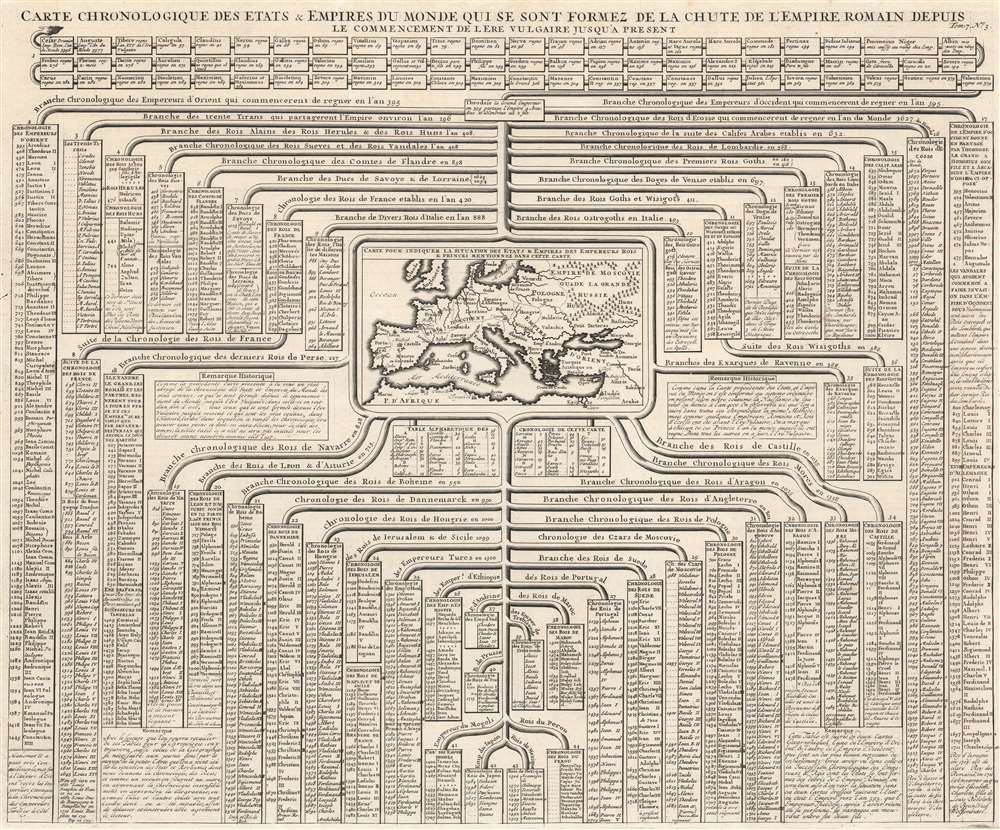
This is a 1720 Henri Abraham Chatelain chart of historical empires and nations from dating from Julius Caesar's Rome, up through through Chatelain's present day. The chart chronicles hundreds of years of human history and separates nations and empires into columns. Among the histories recounted are chronologies of the kings of France, Flanders, Persia, Hungary, Denmark, Ethiopia, Jerusalem, and Russia, along with many others. A map of Europe appears at center. In a short description divided between two boxes, Chatelain explains that these chronologies provide a perspective on history following the fall of the western Roman Empire.
L'Ère Vulgaire
L'Ère Vulgaire is a phrase adopted to identify the era following the birth of Jesus Christ without referencing Christianity or any other religion. The phrase originated in Latin, aerae vulgaris. Vulgaris comes from vulgus, which means 'the common people' and was meant to avoid the regnal year, or the year of the reign of a sovereign. It had no derogatory meaning. The earliest known use of the Latin phrase dates from 1615 in a book by Johannes Kepler. The earliest English usage dates from 1635 in a translation of Kepler's book.Publication History and Census
This chart was published by Henri Abraham Chatelain and François L'Honoré in 1720 in the seventh volume of their Atlas historique, ou Nouvelle introduction à l'histoire, à la chronologie et à la géographie ancienne et moderne... titled Suplément a l'Atlas Historique contenant diverses pièces de Chronologie, de Genealogie, d'Historie, et d'autres Science qui avoient été omises dans les précédens Volumes. This map is not cataloged in OCLC and we note a single digitized example, which is part of a full volume of the Suplément a l'Atlas Historique. The Suplément a l'Atlas Historique is well represented in institutional collections.
Cartographer
Henri Abraham Chatelain (1684 - 1743) was a Huguenot pastor of Parisian origins. He lived consecutively in Paris, St. Martins, London (c. 1710), The Hague (c. 1721) and Amsterdam (c. 1728). He is best known as a Dutch cartographer and more specifically for his cartographic contribution in the seminal seven volume Atlas Historique, published in Amsterdam between 1705 and 1720. Innovative for its time, the Atlas Historique combined fine engraving and artwork with scholarly studies of geography, history, ethnology, heraldry, and cosmography. Some scholarship suggests that the Atlas Historique was not exclusively compiled by Henri Chatelain, as is commonly believed, but rather was a family enterprise involving Henri, his father Zacharie and his brother, also Zacharie. More by this mapmaker...
Source
Chatelain, H., Atlas historique, ou Nouvelle introduction à l'histoire, à la chronologie et à la géographie ancienne et moderne, (Amsterdam: Chatelain) 1720.
Very good. Light wear along original fold lines.
Rumsey 13272.768.