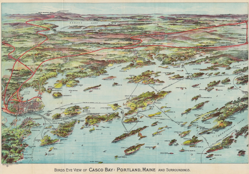
This is a beautiful 1906 George Walker chromolithograph bird's-eye view map of Casco Bay, Portland, Maine. Such views were made for sale at newsstands in stations an onboard ferry lines.
A Closer Look
Casco Bay dominates the foreground and Mount Washington, the White Mountains, and Sebago Lake appear in the background. Harpswell Steam Boat Company connects some islands to Portland. Portland appears in the foreground along the left border with red lines highlighting railroad routes north to Brunswick and Lewiston, west to Montreal and Quebec, and south to Rochester, Worcester, and New York. Islands in Casco Bay (and the communities on them) are labeled. Chromolithography
Chromolithography, sometimes called oleography, is a color lithographic technique developed in the mid-19th century. The process involved using multiple lithographic stones, one for each color, to yield a rich composite effect. Oftentimes, the process would start with a black basecoat upon which subsequent colors were layered. Some chromolithographs used 30 or more separate lithographic stones to achieve the desired product. Chromolithograph color could also be effectively blended for even more dramatic results. The process became extremely popular in the late 19th and early 20th centuries when it emerged as the dominant method of color printing. The vivid color chromolithography produced made it exceptionally effective for advertising and propaganda imagery.Publication History and Census
This view was created and published by George Walker in 1906. We note cataloged examples as being part of the collections at the Leventhal Map Center at the Boston Public Library, the New York Public Library, Yale University, the Library of Congress, the Osher Map Library at the University of Southern Maine, the University of Maine at Orono, and Stanford University.
Cartographer
George Hiram Walker (January 4, 1852 - November 14, 1927) was a Boston based publisher of books, views, and maps active in the late 19th and early 20th centuries. Born in Springfield, Vermont, Walker started his life as a dry goods merchant but developed an active interest in publishing during the early 1870s. Walker began publishing in 1878 when he partnered with an unknown New York Firm. Two years later, Walker brought the operation in house by partnering with his brother, Oscar W. Walker, in the opening of a lithography studio at 81 Milk Street, Boston. Shortly thereafter the firm expanded to new offices at 160 Tremont Street, Boston. The Walker brothers produced a large corpus of works, most of which focused on travel and tourism in New England. Walker also established the Walker-Gordon Milk Laboratory with Dr. Thomas Morgan Rotch and Gustave Gordon. This interesting investment was based on the premise that infant deaths could be avoided by providing higher quality milk. The company eventually became a great success, producing a high-quality cow milk that closely resembled human breast milk. In the process the Walker-Gordon laboratory developed many of the dairy health standards that are still with us today. Walker married Irene L. Loud on March 25, 1885. More by this mapmaker...
Very good. Light wear along original fold lines. Verso repairs to fold separations and at fold intersections. Accompanied by original binder.
Boston Public Library, Leventhal Map Center G3732.C3A3 1906 .W3. OCLC 174968956, 1323555534.