1828 Horsburgh Blueback Nautical Chart of Eastern Philippines (Mindanao, Leyte)

ChinaSheetIII-horsburgh-1828
$1,000.00
Eastern Passages to China Sheet III. - Main View
Processing...

1828 Horsburgh Blueback Nautical Chart of Eastern Philippines (Mindanao, Leyte)

ChinaSheetIII-horsburgh-1828

Sail the Eastern Philippines.
$1,000.00

Title


Eastern Passages to China Sheet III.
  1828 (dated)     39.5 x 26.5 in (100.33 x 67.31 cm)     1 : 2250000

Description


This is an 1828 James Horsburgh blueback nautical chart or maritime map of the eastern Philippines, including the islands of Samar, Leyte, and Cebu (Zebu), as well as parts of the islands of Luzon (Luconia), Panay, Negros, and Mindanao. Numerous coastal locations are labeled on many of the Philippine Islands, including Cebu City (Zebu), as well as points, straits, and bays. Myriad smaller islands are also identified, and Palau (Pellew Islands) is illustrated in the lower right corner. A detailed inset map of Manila Bay is situated along the top border and features numerous depth soundings, identifies coastal settlements, and the lighthouse at Manila.
Little Known Seas
Two different routes to China passing through the North Pacific Ocean are illustrated, with one stated to be best 'from April to September' and the other 'from November to April'. The latter course diverges near the top of the sheet, as a mariner could choose whether they wanted to travel north or south of the Bashee Islands. While the whole of this chart appears to be accurate and full of detail, Horsburgh opens his 'Explanatory Notes' just to the right of the Manila Bay inset in this manner: 'The East Coast of Mindanao is very Imperfectly Known, as few of the Islands comprised in This Chart have been carefully Surveyed along their Coasts…'. He continues with advice concerning the best courses to take during monsoon season, from late November through December, so as to avoid the dangers of these waters.
Blueback Charts
Blueback nautical charts began appearing in London in the late 18th century. Bluebacks, as they came to be called, were privately published large format nautical charts known for their distinctive blue paper backing. The backing, a commonly available blue manila paper traditionally used by publishers to wrap unbound pamphlets, was adopted as a practical way to reinforce the low-quality paper used by private chart publishers in an effort to cut costs. The earliest known blueback charts include a 1760 chart issued by Mount and Page, and a 1787 chart issued by Robert Sayer. The tradition took off in the early 19th century, when British publishers like John Hamilton Moore, Robert Blachford, James Imray, William Heather, John William Norie, Charles Wilson, David Steel, R. H. Laurie, and John Hobbs, among others, rose to dominate the chart trade. Bluebacks became so popular that the convention was embraced by chartmakers outside of England, including Americans Edmund March Blunt and George Eldridge, as well as Scandinavian, French, German, Russian, and Spanish chartmakers. Blueback charts remained popular until the late 19th century, when government subsidized organizations like the British Admiralty Hydrographic Office and the United States Coast Survey, began issuing their own superior charts on high quality paper that did not require reinforcement.
Publication History and Census
This chart was created and published by James Horsburgh in 1828. We note two cataloged examples in OCLC which are part of the collections at Harvard University and the National Library Board of Singapore. It is rarely seen on the private market.

Cartographer


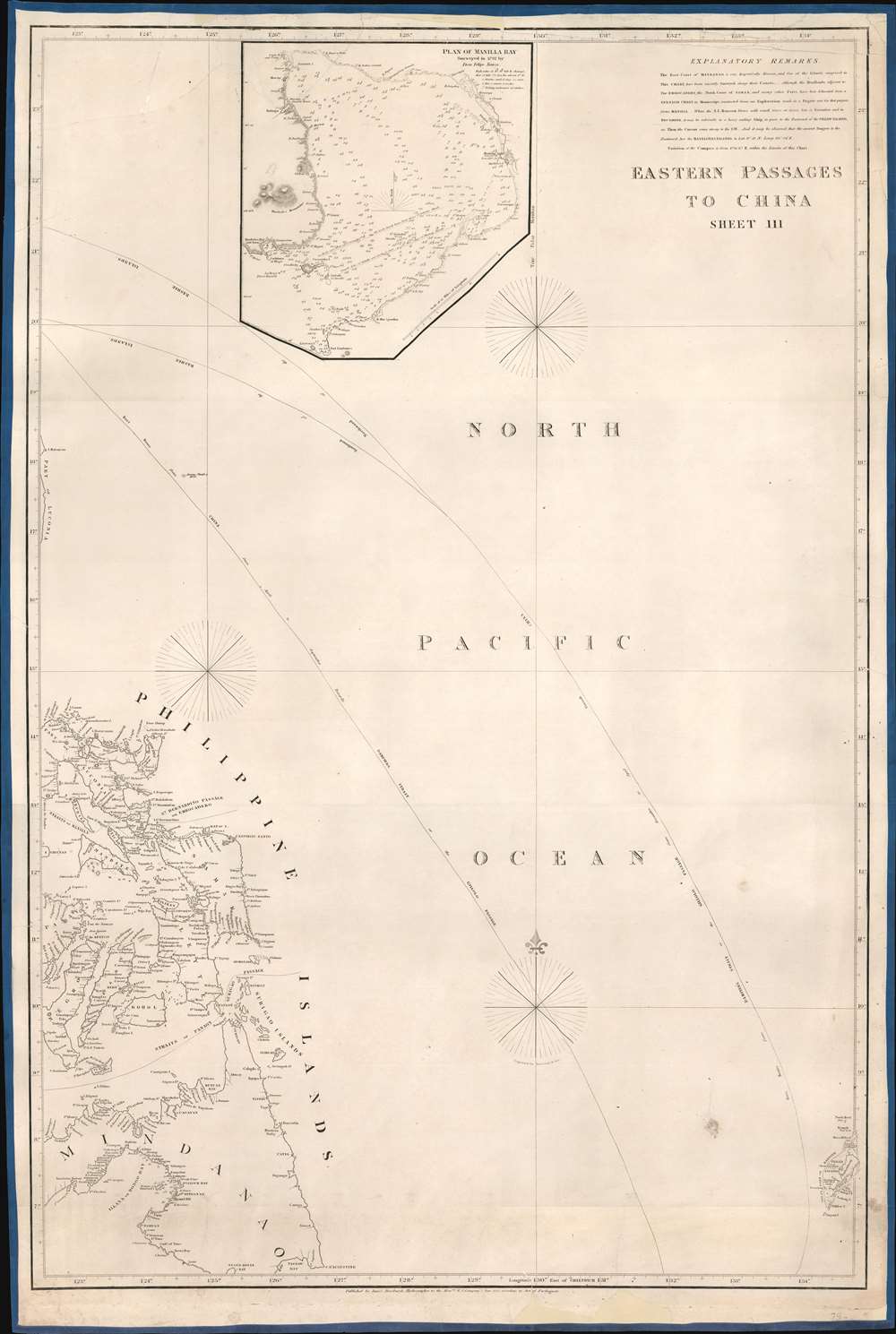
horsJames Horsburgh (September 28, 1762 – May 14, 1836) was a Scottish hydrographer and navigator active in the late 18th and early 19th century. Horsburgh was born in Fife, Elie, Scotland, to a humble family. Like many young Scottish men of little means, Horsburgh was destined for a sea-faring life and at just 16 signed on as a cabin boy in a coal trading ship. After many misadventures, including a brief incarceration by the French at Dunkirk, Horsburgh made his way to the West Indies and eventually to Calcutta, India. As the center for British maritime trade in the region, Horsburgh had no difficulty finding work with the British East India Company who maintained an active trade network between India and China. Despite the regular trade, one these voyages to China, aboard the ironically named Atlas, taught Horsburgh just how poorly the East Indies were charted. The 1786 shipwreck of the Atlas, on which he was the First Mate, near Diego Garcia Island proved a pivotal moment Horsburgh's life. He subsequently devoted himself to accurately charting the Indian Ocean and the dangerous Straits of Malacca, Sunda, and Singapore. Many of Horsburgh's charts are the direct results of his own unique survey work on board the Carron and later as captain of the Anna. Horsburgh's work culminated in the publication if his 1809 Directions for Sailing to and from the East Indies, China, New Holland, Cape of Good Hope, and the Interjacent Ports, a monumentally important guide to navigating the waters of the Indian Ocean and the East Indies. His work earned him friendships in London's highest naval and scientific circles, among them Joseph Banks and Alexander Dalrymple. He became a member of the Royal Society in 1806, when he retired from active sailing. When Alexander Dalrymple died in 1810, Horsburgh was appointed to the prestigious position of Hydrographer to the British East India Company where he worked until his death in 1836. Whereas Dalrymple was somewhat indiscriminate regarding the charts he published, Horsburgh was exacting and double checked the veracity of each and every chart that passed through his office. Horsburgh's work with the East India Company elevated the standards of the Hydrographic Department and earned him a Fellowship with the Royal Society. Today's Horsburgh's accomplishments are memorialized by the Horsburgh Lighthouse, near Singapore, and Horsburgh Island. When Horsburgh died most of his work was passed by his children to the Admiralty, which continued to publish updates until roughly 1864. More by this mapmaker...

Condition


Good. Professionally restored and rebacked. Areas of infill along top and bottom borders.

References


OCLC 922675365.