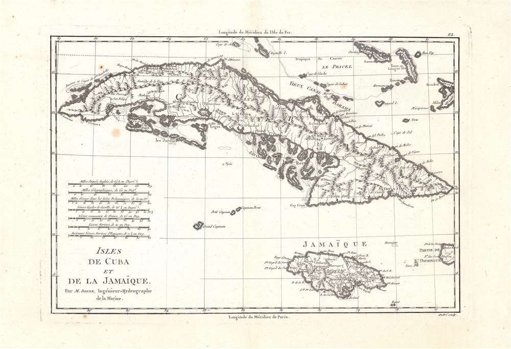
This is Rigobert Bonne's 1788 map of Cuba, Jamaica, and surrounding islands, prepared for his and Nicolas Desmarest's Atlas encyclopédique. It depicts the islands as the region was undergoing important changes at the end of the 18th century that signaled the coming collapse of slavery and the plantation economy.
A Closer Look
Coverage includes Cuba, Jamaica, nearby surrounding islands (such as the Cayman Islands), and portions of Saint Domonique and the Bahamas. Mountains, rivers, and settlements are depicted in gorgeous detail. Coastal hazards and shoals are indicated. Seven different scales are provided, while longitude is measured from both Paris and the Ferro Meridian.Historical Context
This map was published as Cuba, Jamaica, and the entire region underwent rapid shifts due to the Seven Years' War, residual inter-imperial competition, slave uprisings, and the Age of Revolutions. During the Seven Years' War (1756 - 1763), Cuba was conquered by the British but exchanged in the Treaty of Paris for Florida (which was later reconquered by Spain during the American Revolution). For its part, Jamaica witnessed several slave and maroon uprisings in the second half of the 18th century, harbingers of the end of the slave trade and the abolition of slavery several decades later. Cuba remained an outlier in the region, resisting both independence and abolitionist movements until the late 19th century.Publication History and Census
This map was prepared by Rigobert Bonne and engraved by André (given name unknown). It appeared in the second volume of Bonne and Nicolas Desmarest's 1788 edition of the Atlas encyclopédique. As some OCLC listings include digitized copies, the full distribution of the map is difficult to determine, but it is independently cataloged at a handful of institutions in North America and Europe while the entire atlas is more widely distributed.
Cartographer
Rigobert Bonne (October 6, 1727 - September 2, 1794) was one of the most important French cartographers of the late 18th century. Bonne was born in Ardennes à Raucourt, France. He taught himself mathematics and by eighteen was a working engineer. During the War of the Austrian Succession (1740 - 1748) he served as a military engineer at Berg-op-Zoom. It the subsequent years Bonne became one of the most respected masters of mathematics, physics, and geography in Paris. In 1773, Bonne succeeded Jacques-Nicolas Bellin as Royal Cartographer to France in the office of the Hydrographer at the Depôt de la Marine. Working in his official capacity, Bonne compiled some of the most detailed and accurate maps of the period - most on an equal-area projection known erroneously as the 'Bonne Projection.' Bonne's work represents an important step in the evolution of the cartographic ideology away from the decorative work of the 17th and early 18th century towards a more scientific and practical aesthetic. While mostly focusing on coastal regions, the work of Bonne is highly regarded for its detail, historical importance, and overall aesthetic appeal. Bonne died of edema in 1794, but his son Charles-Marie Rigobert Bonne continued to publish his work well after his death. More by this mapmaker...
Source
Bonne, Rigobert and N. Desmarest, Atlas encyclopédique contenant la géographie ancienne, et quelques cartes sur la géographie du moyen age, la geographie moderne, et les cartes relatives a la géographie physique, (Paris: Hôtel de Thou), Vol. II, p. 112.. 7.. 7, 1788.
Good. A few spots of discoloration inside the neatline, with some more imperfections in the margins.
OCLC 643746734, 431584514, 634675342.