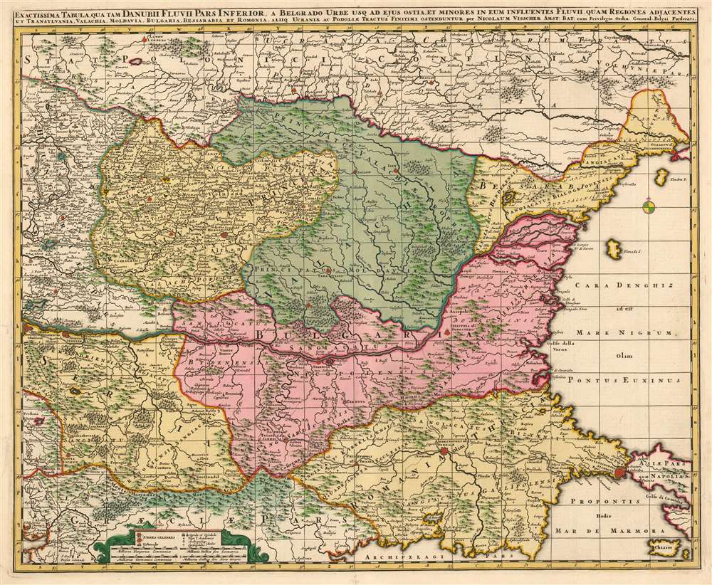
This is a beautiful, contemporary-color example of Nicolas Visscher's c. 1677 map of the lower Danube River, showing the Turkish administrative regions along the Black Sea coast. The map encompasses Transylvania, Serbia, Wallachia, Bulgaria and Romania. Portions of Greece and the Ukraine appear as well. Belgrade, Bucharest, and Istanbul are among the major cities appearing here. This map is notable in naming the Sanjaks, or Ottoman provinces in this contentious frontier region. These extend from the Sanjak of Ochakov (Ukraine on the Black Sea Coast) to the Sanjak of Gallipoli on the Sea of Marmora. Turkish rule in these regions was, by the time this map was produced, so established that many of the place names here are given both in approximations of the Turkish toponymy as well as European.
Beauty and Utility
The maps of the Visscher family are prized for the superb quality of engraving and the high level of artistry in their compositions; this map is no exception. They generally employed larger plates and finer detail than the mapmakers of the first half of the 17th century, improving the clarity of the maps and allowing the addition of more geographical detail. While the appeal of the map to the modern viewer is primarily visual, there are many features which indicate the map was meant to be easily consulted and comprehended, in spite of the density of detail offered by the piece. For example, the Dalmatian coast's complicated archipelago includes dotted borders indicating the duchies to which the various islands belong. The latitude and longitude lines serve double-service, by providing the framework for a coordinate grid keyed to exhaustive tables of place names printed on the verso of the map.The Legend
The maps's multiplicity of named cities and towns is made more legible by the inclusion of a legend, indicating the sizes of the settlements with different symbols. Famous cities (Vienna, Belgrade) are given more pictorial symbols than smaler cities, forts and villages. The addition of a cross indicates a bishop's seat; a double-armed cross does for that of an archbishop. A caduceus is used to indicate the presence of an academy - although in this map no such locations appear. A number of villages are marked with a symbol reminiscent of a pennant, which does not appear in the legend. They appear near the Danube in Serbia and just across the river into Hungary: Wadazin, Maraculla and Pescabara. We see reference to Pescabara as a Turkish garrison town, and so likely all of these settlements fall in this category. Some of these - notably the Bulgarian city of Kyustendil (Giustandil on the map) are marked as noteworthy cities, another testament to the long establishemnt of Turkish rule in the region.Publication History and Census
This map was engraved for inclusion with Visscher's Atlas Contractus It is sometimes dated as early as 1658, but it cannot have been produced earlier than 1660, the year the dedicatee van Hoorn took part in his embassy to London. It is far more likely that it was engraved in the vicinity of 1670, with the dedication being added to honor van Hoorn posthumously. The presence of thAtlas Minor, the composite atlas published by the family starting in the mid-1670 and continuing without change into the 18th century. Fifteen examples of the Atlas Minor appear in OCLC with varying pagination; OCLC also catalogues various examples of the separate map.
Cartographer
Claes Jansz Visscher (1587 - 1652) established the Visscher family publishing firm, which were prominent Dutch map publishers for nearly a century. The Visscher cartographic story beings with Claes Jansz Visscher who established the firm in Amsterdam near the offices of Pieter van den Keer and Jadocus Hondius. Many hypothesize that Visscher may have been one of Hondius's pupils and, under examination, this seems logical. The first Visscher maps appear around 1620 and include numerous individual maps as well as an atlas compiled of maps by various cartographers including Visscher himself. Upon the death of Claes, the firm fell into the hands of his son Nicholas Visscher I (1618 - 1679), who in 1677 received a privilege to publish from the States of Holland and West Friesland. The firm would in turn be passed on to his son, Nicholas Visscher II (1649 - 1702). Visscher II applied for his own privilege, receiving it in 1682. Most of the maps bearing the Visscher imprint were produced by these two men. Many Visscher maps also bear the imprint Piscator (a Latinized version of Visscher) and often feature the image of an elderly fisherman - an allusion to the family name. Upon the death of Nicholas Visscher II, the business was carried on by the widowed Elizabeth Verseyl Visscher (16?? - 1726). After her death, the firm and all of its plates was liquidated to Peter Schenk. More by this mapmaker...
Source
Visscher, Nicolas II Atlas Minor Amsterdam c. 1677
Good condition. Marginal mends with no loss to image. Rich contemporary color.
OCLC 165836384.