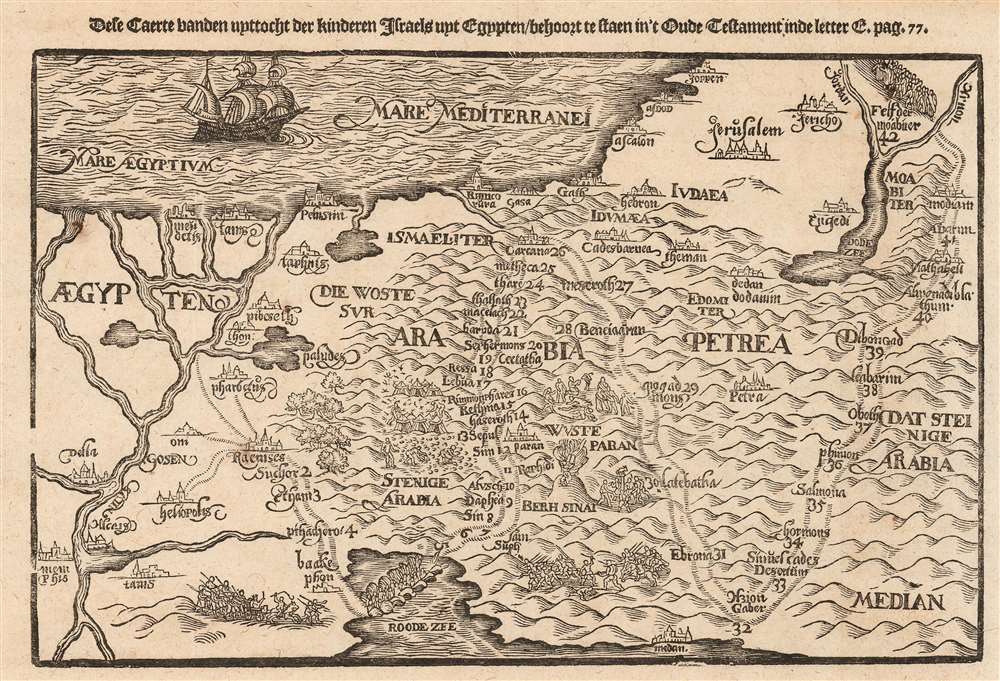
This is a scarce 1635 Dutch woodcut map of the Holy Land, depicting the peregrination of the Israelites from Egypt to the Jordan River. The map illustrates the path of the Exodus, numbering the various stops. Biblical scenes are depicted in vignettes: the parting of the Red Sea with the Egyptians in pursuit; the gathering of manna in the desert; Moses receiving the Ten Commandments whilst the Israelites worship the Golden Calf; and battle scenes. The Mediterranean is decorated with a fine sailing ship.
Publication History and Census
This woodcut appeared in a 1635 Matthias Hasaert Dutch edition of Heinrich Bünting's Itinerarium Sacrae Scripturae, a paper pilgrimage to the Holy Land first printed in 1581. Its popularity kept it in print into the 18th century. The formschneider is unknown. There are seventeen examples of the Hasaert-published Bünting Itinerarium listed in OCLC. There are no examples of this map cataloged in institutional collections.
Cartographer
Heinrich Bünting (1545 – 1606) was a Protestant pastor and theologian. He was born in Hanover, and studied theologian Witemberg. He is best known for his book of woodcut maps titled Itinerarium Sacrae Scripturae (Travel book through Holy Scripture) first published in 1581. It was the first complete summary of biblical geography available. More by this mapmaker...
Source
Hasaert, Matthias/ Laurensz, Hendrick, Itinerarium Sacrae Scripturae. Dat is: Het reysboeck der heyligher Schrift, (Amsterdam), 1635.
Very good. Light toning at edges, else excellent with a bold strike.